Lake Roosevelt Water Level – Updated Daily
A foot of change at Lake Roosevelt isn’t a footnote – it can expose a boat ramp, shift a familiar cove, or push hazards closer to the surface than they were last weekend. That’s why the Lake Genius app updates water levels every day, so you know what you’re heading into before you leave home.
Today's Water Level at Lake Roosevelt
To check today’s water level at Lake Roosevelt, download the Lake Genius app! Lake Roosevelt’s water level is measured in feet above sea level, and it moves based on snowmelt, dam operations, irrigation draws, and seasonal patterns along the Salt River and Tonto Creek watersheds. The Lake Genius app reflects the current level every day, with the red shoreline on your map adjusting automatically.
Once downloaded:
- 1. Open Lake Genius and navigate to Lake Roosevelt
- 2. Tap the Water Level button
- 3. See the current level in feet or meters – your preference
- 4. The red shoreline updates to match today's conditions
How Lake Roosevelt's Water Level Works
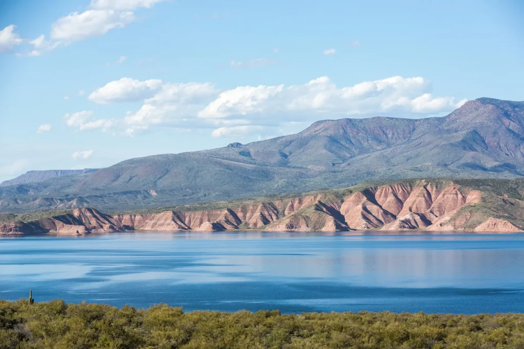
Lake Roosevelt is a managed reservoir – the oldest and largest in Arizona – held back by Roosevelt Dam on the Salt River. The Salt River Project (SRP) operates the dam to balance water supply for the Phoenix metro area, agricultural irrigation, and flood control. That means the water level can change based on factors well beyond rainfall.
What Drives the Changes
- Snowpack and runoff: Spring melt from the White Mountains and Mazatzal range drains into the Salt River and raises the lake.
- Monsoon season: Summer storms can push the level up quickly – sometimes several feet in a matter of days.
- Irrigation draws: Water is released downstream throughout the growing season, pulling the level down.
- Dam management: SRP adjusts releases year-round based on forecasted demand and flood risk.
For boaters, this matters at the practical level: the ramp that worked in April may look different in August. A cove you anchored in last summer may be shallower – or deeper – depending on the season and recent conditions.
How Lake Genius Tracks It
Lake Genius pulls water level data from government sources – the same data used by the Bureau of Reclamation and SRP – and processes it through our proprietary pipeline. Every day, the numbers update. Every day, your map reflects what’s actually happening at the lake.
Government source data: Bureau of Reclamation and SRP monitoring stations provide daily readings.
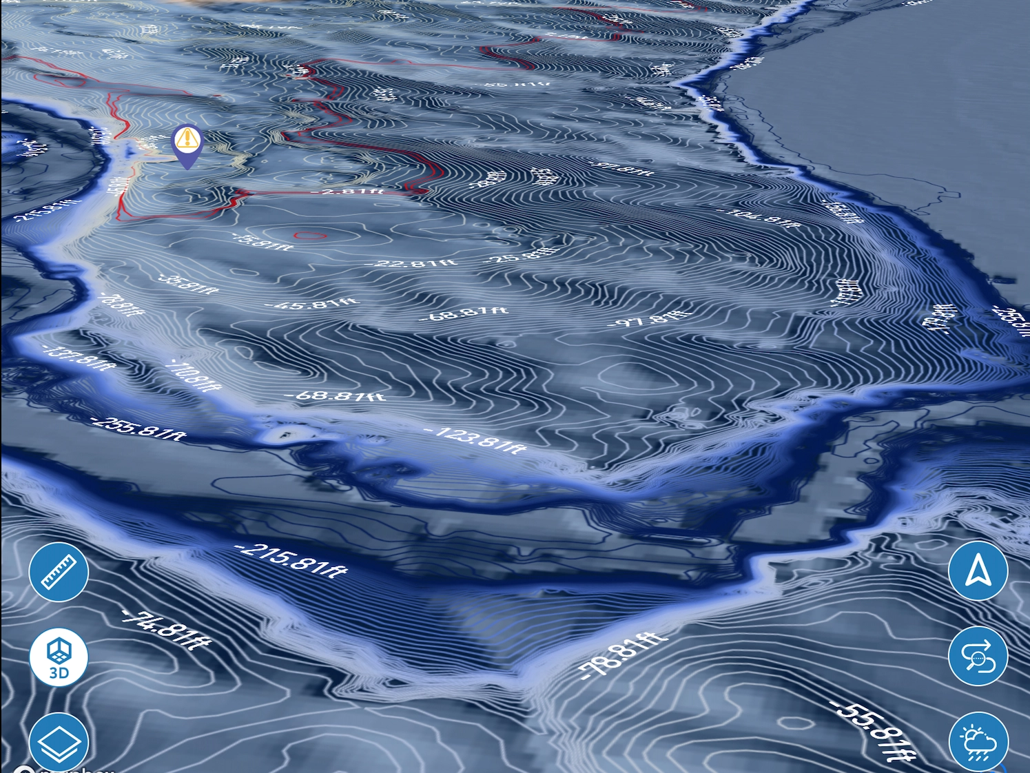
Proprietary processing: Lake Genius combines that data with underwater contour mapping to determine what’s near the surface.
X-Ray View update: The hazard detection layer recalculates based on the current level – hazards you see reflect today’s water, not last month’s.
Red shoreline display: The current water boundary appears in red on your map – you always know where the lake ends and the rocks begin.
What Changing Levels Mean for Boaters
A water level reading is more than a number. It’s a preview of what you’re going to encounter on the water.
Boat Ramp Access
Ramps at Lake Roosevelt can become unusable when the water level drops. Arriving with a loaded trailer and finding a ramp you can’t use wastes half your day. Checking the level in the app before you leave lets you adjust your plan – use a different ramp, launch from a different spot, or know what to expect when you get there.
Shallow Water and Underwater Hazards
As the water level moves down, rocks and submerged terrain that were safely below the surface get closer to the top. The Lake Genius X-Ray View highlights anything within 9 feet of the current surface – the depth range where propellers and hulls are most at risk. Boat repair shops across Arizona confirm that prop and hull damage from underwater hazards runs $5,000–$10,000+ per incident. Knowing where those hazards are before you throttle up is the whole point.
Coves and Anchoring Spots
Favorite spots move with the water. A cove that’s perfect at high water might be rocky and shallow at low water – or vice versa. The app shows you the current lay of the land so you’re not guessing.
Fishing Depth
Lake Roosevelt holds bass, catfish, crappie, and carp. The app lets you manually set a custom water level to scout depth contours and identify structure at different readings – useful when planning a trip around seasonal conditions.
Pro Tip: Check Before You Leave Wi-Fi
Cell coverage at Lake Roosevelt is limited once you’re in the canyon. Open Lake Genius before you leave home, check today’s water level, download your offline maps, and you’re set. Everything you need works without a signal once it’s downloaded.
Pairs With X-Ray View
Water level and hazard detection aren’t separate features – they work together. When the water level moves, the hazards move with it. The X-Ray View updates every day to reflect the current level, so the underwater terrain you see matches the terrain you’ll actually encounter.
See depth contours beneath the surface as you zoom in on the map.
Hazards within 9 feet of the current surface are highlighted automatically.
The red shoreline shows exactly where water meets land at today’s level.
Water level tells you the number. X-Ray View shows you what it means for what’s under your boat.
TESTIMONIALS
What Boaters Are Saying
TESTIMONIAL PLACEHOLDER #1
A testimonial about the overall app experience — ideally from a boater who used multiple features on a single trip. Example: someone who planned from home, used the X-Ray View on the water, and found a hidden cove via POI. Should convey “this app changed how I experience the lake.”
— John
- Bear Lake
TESTIMONIAL PLACEHOLDER #1
A testimonial focused on hazard avoidance or money saved — someone who spotted a hazard before it became a problem. Connects to the X-Ray View and water levels features. Should convey “this paid for itself immediately.”
— Steve
- Bear Lake
TESTIMONIAL PLACEHOLDER #1
A testimonial about offline reliability or trip planning from home — especially relevant for families or houseboat renters. Should convey “I was confident even in areas with no cell service” or “we planned the whole trip before we left.”
— Gabrielle
- Lake Powell
Frequently Asked Questions
What is the current water level at Lake Roosevelt?
What is the current water level at Lake Roosevelt?
Lake Roosevelt’s water level updates daily in the Lake Genius app. Open the app to see the current level in feet above sea level, along with the red shoreline showing exactly where water meets land today.
Is Lake Roosevelt water level rising or dropping?
Is Lake Roosevelt water level rising or dropping?
It depends on the season and current dam operations. The Lake Genius app shows the current level and how much it has moved from the prior day – so you always know which direction the water is heading.
How often does Lake Genius update Lake Roosevelt water levels?
How often does Lake Genius update Lake Roosevelt water levels?
The app updates every day. Data flows from Bureau of Reclamation and SRP monitoring stations through our processing pipeline, and the map reflects the latest available reading.
Why does Lake Roosevelt's water level change so much?
Why does Lake Roosevelt's water level change so much?
Lake Roosevelt is a managed reservoir. The Salt River Project releases water for Phoenix-area irrigation and municipal supply throughout the year, and dam operations adjust based on flood control and forecasted demand. Snowmelt and monsoon runoff add more variability on top of that.
How deep is Lake Roosevelt?
How deep is Lake Roosevelt?
At full pool, Lake Roosevelt reaches depths over 200 feet near the dam. Depth varies significantly across the lake – shallower in the upper arms, with dramatic drop-offs in the main channel. The Lake Genius app shows depth contours so you can see the terrain before you get there.
Does the Lake Genius app work at Lake Roosevelt without cell service?
Does the Lake Genius app work at Lake Roosevelt without cell service?
Yes. Download your maps before you leave home and the app runs fully offline – water level display, X-Ray View, POI markers, and GPS tracking all work without a signal. Water level updates and weather notices require a connection when you access those features, so check before you leave Wi-Fi.
Know the Level Before You Go
See Today’s Level in the App – Download Free


Free trial · No credit card required · Works offline