
Plan Your Lake Trip From Home
With Lake Genius, you can map out your entire trip before you leave the house – scout the best coves, plot your route, estimate travel time, and know exactly where you’re headed before you ever back the trailer down the ramp.
Once you’re on the water, GPS route tracking follows your path in real time. Save every route you run so you can retrace your steps next season – or share your favorite runs with friends via text.


Start your free trial · No credit card required
Plan Your Route Before You Leave Home
Most boaters don’t get to the lake every weekend. When you only get a few trips a year, every hour on the water counts. Lake Genius lets you plan your entire route from home – days or even weeks before your trip.
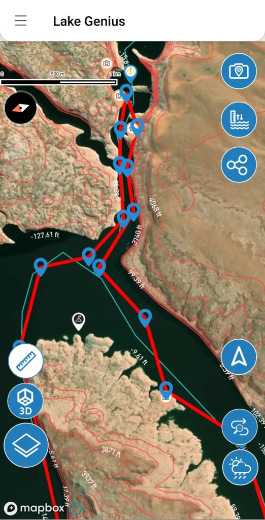
Open the app, explore the map, and start dropping waypoints. Pick the coves you want to visit, the marinas you need for fuel, the beaches you want to anchor at for lunch. The app estimates your travel distance and time between stops, so you can build a realistic itinerary before you even pack the cooler.
This is especially valuable for families renting houseboats at Lake Powell or planning a first visit to Lake Mead. Instead of burning vacation time figuring things out on the water, you arrive with a plan and make the most of every day.
GPS Route Tracking on the Water
In planning mode, the app estimates your travel distance and time, so you can plan efficient days on the water.
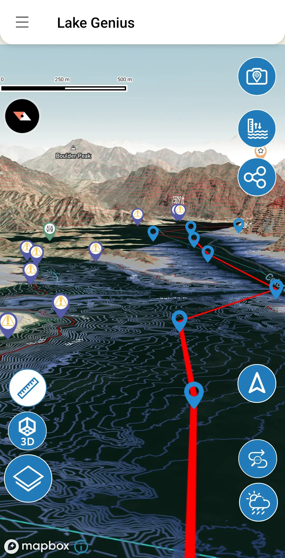
Once you’re on the water, Lake Genius can track your route using your device’s GPS. Just toggle it on and your path is drawn on the map as you go, giving you a clear visual of where you’ve been – and how to get back.
This is a game-changer on big water. Lake Powell has 96 side canyons and over 2,000 miles of shoreline. Lake Mead stretches across two states. It’s easy to lose your bearings, especially if you’re exploring new areas. GPS tracking means you always have a breadcrumb trail to follow home.
Save Unlimited Routes – Retrace Your Best Days
Found the perfect loop through Padre Bay? Discovered a shortcut to Antelope Canyon that saved you 30 minutes? Save it. Lake Genius lets you save unlimited routes so you can retrace your best days on the water – this season and every season after.
Every saved route stays in the app until you delete it. Over time, you build a personal library of your favorite runs across every lake you visit. No more guessing, no more “I think it was that canyon” – just pull up last year’s route and go.
This is especially useful for fishermen who run the same productive routes repeatedly, or families who want to recreate that perfect beach day from last summer.
Share Your Routes With Friends and Family
Heading to the lake with a group? Share your planned stops with anyone via text message. The recipient taps the link, the app opens, and the marker is added to their map automatically. No screenshots, no back-and-forth – just tap, open, done.
This works great for coordinating with other boats in your group, sharing your favorite route with a buddy who’s heading out next weekend, or sending your planned itinerary to family back home so they know where you’ll be.
Your Plan Goes Where You Go – Even Without Cell Service
If you’ve been to Lake Powell, you already know: cell coverage disappears once you leave the marina. Most of Lake Mead’s canyons are the same story.
Lake Genius works offline. Download your maps before you head out and your planned routes, saved markers, GPS tracking, and the X-Ray View all work without a cell connection. You planned your trip from home, and it’s all there when you need it most – even in the most remote canyon on the lake.
Plan Trips Across Multiple Lakes – And Growing
Trip planning, GPS route tracking, and all the features on this page work across every lake in the Lake Genius app – currently including Lake Powell, Lake Mead, Bear Lake, Lake Tahoe, Lake Roosevelt, and Lake Pleasant, with more on the way.
Each lake has its own map data, points of interest, and daily updates. Plan a Lake Powell houseboat adventure, a weekend bass fishing trip on Lake Mead, or a family beach day at Bear Lake – all from the same app, with the same powerful planning tools.
Lake Powell
The most dramatic water level story of any lake we cover. Powell’s levels have fluctuated significantly over the past decade, reshaping the shoreline, exposing new hazards, and changing which canyons are navigable season to season. If there’s one lake where daily water level tracking is non-negotiable, it’s Powell.
Lake Mead
Lake Mead’s water level changes have made national headlines. Dramatic drops have revealed everything from submerged boats to previously hidden geological features. For boaters, the practical impact is straightforward: the underwater landscape at Mead has been completely reshaped, and what was deep water a few years ago may be dangerously shallow today.
Bear Lake
Bear Lake is generally more stable than Powell or Mead, but levels still shift with snowpack and seasonal conditions. Daily tracking gives you confidence at the ramp and on the water – especially if you’re visiting for the first time and don’t have a local’s feel for the lake.
Lake Tahoe
Lake Tahoe’s level rises with winter snowpack and falls through the boating season, and the near-shore depth changes meaningfully as it does. Knowing today’s reading matters when you’re navigating granite-lined shorelines where the bottom comes up fast.
Lake Roosevelt
Lake Roosevelt’s water level swings significantly across the year – what’s deep water in summer can be a very different picture by fall. Daily tracking is the only reliable way to know what you’re navigating into on a lake this remote and this large.
Lake Pleasant
Lake Pleasant fills through winter and drops through summer, and levels can shift noticeably within a single season of Phoenix heat. What was deep enough last weekend might not be next – which is exactly what daily water level tracking is built for.
Lake Havasu
45 miles of Colorado River, from Lake Havasu City down to Parker Dam. Hundreds of hidden coves, the famous Bridgewater Channel, and some of the busiest summer boating in the West. Lake Genius maps the channels, marinas, and quiet anchorages, with daily underwater hazard updates and offline maps for when cell service drops in Topock Gorge.
Flaming Gorge
Carved through red rock canyons along the Utah-Wyoming border, Flaming Gorge is a 91-mile reservoir famous for trophy lake trout and dramatic, season-driven water level swings. Lake Genius tracks those changes daily and maps every marina, ramp, and cove, so you navigate the canyons and find the fishing without guessing what’s beneath you.
Mohave
67 miles of Colorado River between Hoover Dam and Davis Dam, with 237 miles of shoreline, canyon hot springs, and the quieter water boaters head to when Lake Mead gets crowded. Water levels move daily with dam operations, and Lake Genius tracks every change — so you know which ramps are open and what’s under the water before you launch.
TESTIMONIALS
What Boaters Are Saying
We’ve taken several family houseboat trips to the lake in years past. We normally relied on maps.
I was happy to find an affordable electronic option when I learned of Lake Genius, so downloaded it and subscribed prior to our trip in mid-October 2025. Looking at the app at home I was impressed with the amount of detail concerning elevations and landmarks. In use on the lake, I had a hard time finding a zoom level that would show me both buoy locations and enough elevation / depth information to be useful while underway, but recent updates have fixed that. We found the app very useful overall and a great value.
— DonJ60
Rarely do I leave reviews on apps, but this is an absolute must have in Lake Powell!!
Thank you for an awesome app to help with boating —especially with Lake Powell newbies like us. Heck, even my long time Lake Powell buddies thought this was amazing.
— Mxracer317
- Lake Powell
This app is awesome!
Such a great way to spot underwater hazards easily on your phone. Saves you a lot of hassle and money from hitting your prop on a rock!
— Liv.ballam
Frequently Asked Questions
Can I plan my lake trip from home before I leave?
Can I plan my lake trip from home before I leave?
Yes. Open the app from anywhere and explore the full map. Drop waypoints, plan your route, estimate distance and travel time, and save everything – all before you leave home. Your planned route will be there when you arrive at the lake, even without cell service if you’ve downloaded your maps.
Can Lake Genius track my GPS route on the water?
Can Lake Genius track my GPS route on the water?
Yes. Lake Genius displays water levels in feet or meters depending on your settings. Tap the Water Level button on any lake to see the current reading in your preferred unit.
Can I save and reuse routes from previous trips?
Can I save and reuse routes from previous trips?
Absolutely. Save unlimited routes in the app and pull them up anytime. Whether you want to retrace last summer’s fishing loop or recreate a family beach day, your saved routes are always available.
Can I share my route or planned stops with friends?
Can I share my route or planned stops with friends?
Yes. Share any marker with friends and family via text message. The recipient taps the link, the app opens, and the marker is added to their map automatically. The recipient needs Lake Genius installed to receive shared markers.
Does trip planning work offline?
Does trip planning work offline?
Yes. Download your maps before your trip and all planning features, saved routes, GPS tracking, and the X-Ray View work without cell service. Water level updates and weather info require an internet connection when accessed.
Does Lake Genius provide turn-by-turn navigation?
Does Lake Genius provide turn-by-turn navigation?
Lake Genius provides GPS route tracking and route display on the map – not turn-by-turn voice navigation. You can see your planned route, track your position in real time, and save your path, but the app does not provide spoken turn prompts.
Is trip planning included in the free trial?
Is trip planning included in the free trial?
Yes. Every feature in the app – including trip planning, GPS route tracking, the X-Ray View, and all 2,000+ points of interest – is available during the free trial. No credit card required.
Start Planning Your Next Trip
Your best day on the lake starts at home. Download Lake Genius, explore the map, plan your route, and arrive at the ramp ready to go.
5,000+ downloads · Trusted by marina operators