Lake Mead Map – Depth, Hazards & Navigation in Your Pocket
Lake Mead’s underwater terrain has changed dramatically as water levels have moved over the years. Areas that were deep are now shallow. Coves that were wide open have tightened. The paper map you bought at the marina can’t show you any of that – but the Lake Genius map can. Underwater depth contours, daily hazard updates, 700+ points of interest, and offline access in one app.


Start your free trial · No credit card required
More Than a Paper Map
If you’ve boated Lake Mead before, you may have picked up a paper map at the marina or used a generic navigation app on your phone. Both will show you where the land is. Neither will show you what’s under the water.
A paper map is a snapshot of the lake from whenever it was printed. It doesn’t account for water level changes, and it can’t flag underwater hazards that have shifted since last season. A general navigation app – the kind built for roads – has zero underwater data and stops being useful the moment you leave the dock.
Lake Genius is built specifically for lakes like Mead. The map shows underwater terrain and depth contours, updates daily based on the current water level, marks 700+ curated points of interest, and works offline in remote areas where your phone has no signal. It’s the difference between guessing and knowing.
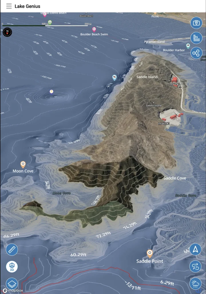
Underwater Terrain & Depth Contours
Lake Mead’s depth varies enormously – from hundreds of feet near Hoover Dam to surprisingly shallow shelves in the coves and arms. And because water levels have moved so significantly over the years, the underwater landscape looks different today than it did even a few seasons ago.
Zoom in on the Lake Genius map and you’ll see the X-Ray View – a simulated 3D visualization of the terrain beneath the surface. Underwater elevation contours show you the depth profile, and the current water line is highlighted in red so you always know where the boundary is. Hazards within 9 feet of the surface are flagged because that’s the range where propellers, hulls, and water sports riders are most at risk.
This data updates daily based on the current water level. So the depth contours and hazard flags you see today reflect today’s conditions – not a survey from five years ago.
Two States. Three Basins. One Map That Covers It All.
Lake Mead stretches across the Nevada-Arizona border, and most first-time visitors don’t realize how much lake there is beyond the Boulder Basin close to Las Vegas. The reservoir spans three major basins, two long arms, and over 750 miles of shoreline carved through desert canyons – each section with its own character, its own access points, and its own underwater terrain.
Boulder Basin
The closest section to Las Vegas and the most heavily visited. This is where Las Vegas Boat Harbor and Callville Bay sit. The basin is wide, open, and relatively accessible – but the underwater terrain is more complex than the surface suggests. Water level changes at Mead have reshaped what’s below the surface here more dramatically than almost anywhere in the country.
Virgin Basin and the Overton Arm
Head northeast from Callville Bay and the lake narrows into the Overton Arm – a long, scenic stretch that feels entirely different from the Boulder Basin. Less traffic, more remote coves, and cell coverage that fades the further north you go. Echo Bay sits at the gateway to this section.
Temple Bar and the Arizona side
Cross into Arizona and Lake Mead gets quieter. Temple Bar provides access to some of the most scenic and least crowded water on the reservoir. The canyons here are narrower, the shoreline more rugged, and the underwater structure more varied.
The Narrows and Colorado River arm
South of the main reservoir body, Lake Mead extends along the Colorado River toward Cottonwood Cove. This arm is popular for its protected waters, dramatic canyon walls, and excellent striped bass fishing.
The Lake Genius map covers every section – all basins, both states, every major arm and cove. Whether you’re running from Vegas Boat Harbor to a quiet beach in the Overton Arm or exploring the Arizona side for the first time, the map has the underwater terrain, POI markers, and depth data you need for that specific stretch of the lake.
Marinas & Access Points – Nevada and Arizona Sides
Lake Mead stretches across two states, with marinas and boat ramps on both the Nevada and Arizona sides. The Lake Genius map marks them all so you can find fuel, services, and launch points wherever you’re headed.
On the Nevada side, Las Vegas Boat Harbor and Callville Bay are the closest marinas to the Las Vegas Strip – popular with weekend boaters making the 30–45 minute drive from the city. Cottonwood Cove sits further south along the Colorado River arm of the lake. On the Arizona side, Temple Bar and Echo Bay provide access to the quieter, more remote stretches of the reservoir.
Each marina is marked on the map with details like fuel availability, boat ramp access, and nearby amenities. You can plan your launch point from home and know exactly where to find services once you’re on the water.
Fish Smarter With the Depth Map
Lake Mead is one of the best striped bass fisheries in the Southwest, and anglers also target largemouth bass, catfish, and crappie depending on the season. Knowing the underwater structure – drop-offs, submerged ledges, humps, and channels – is the difference between fishing blind and fishing with confidence.
The Lake Genius map shows you that structure. Zoom in to see depth contours and underwater terrain at any point on the lake. You can also manually adjust the water level in the app to scout what the lake looks like at different depths – ideal for finding the sweet spots where fish tend to hold based on current conditions.
Combine the depth data with custom markers and the Photo Marker feature, and you can build your own fishing map over time – tagged with locations, photos, and notes that only you can see.
Build Your Own Lake Mead Map
Lake Genius starts with 700+ curated points of interest at Lake Mead – but your map doesn’t have to stop there. Drop custom markers on any spot you want to remember: a quiet cove, a reliable fishing hole, a great beach for the family, a spot to avoid. Name them, pick an icon, and they’re saved permanently.
The Photo Marker feature takes it a step further. Snap a photo of something you want to mark – a rock formation, a shoreline feature, a cove entrance – and the app pins it on the map for you. Over time, your Lake Mead map becomes yours: a personalized guide built from your own experience on the water.
Share any marker with other Lake Genius users via text message. They tap the link, the app opens, and the marker is on their map. It’s the easiest way to show someone exactly where to meet, where to anchor, or where the fish were biting.
Download the Map for Offline Use
Lake Mead has decent cell coverage near the major marinas and the Las Vegas side, but once you head up the Overton Arm, toward Temple Bar, or into the remote coves on the Arizona side, signal drops off. Download the Lake Mead map before your trip and all the core features work offline – depth contours, underwater terrain, points of interest, GPS tracking, and saved routes.
Weather and the latest water level reading require an internet connection when you access them. Best practice: check both at the marina or before you leave your hotel, and you’re covered for the day.
Paper Map vs. Generic App vs. Lake Genius
Capability
Daily underwater hazard updates
Water level–adjusted depth contours
X-Ray View (9-ft hazard zone)
Both NV and AZ sides covered
700+ curated POI (marinas, beaches, fishing)
Works offline in remote areas
Custom markers & photo pins
Built specifically for Lake Mead
Paper Map from the Marina
- Static – printed months or years ago
- No
- No
- Often one side only
- A few printed labels
- It's paper
- No
- Lake-specific but outdated
Generic Navigation App
- No daily inland lake data
- No
- No
- Road data only
- Limited or road-based
- Requires cell connection
- No or limited
- Worldwide / generic
Lake Genius
- Updated daily based on current level
- Recalculates nightly
- 3D underwater terrain
- Full lake, both states
- Curated, not crowdsourced
- Full offline after download
- Unlimited + shareable
- Purpose-built, updated daily
Lake Mead’s underwater landscape has changed more than almost any lake in the country. A map printed even a year ago can’t account for what’s happened since. Lake Genius recalculates daily – so the map you’re using reflects the lake you’re actually on, not the lake someone charted last season.
TESTIMONIALS
What Lake Mead Boaters Are Saying
TESTIMONIAL PLACEHOLDER #1
A testimonial about the overall app experience — ideally from a boater who used multiple features on a single trip. Example: someone who planned from home, used the X-Ray View on the water, and found a hidden cove via POI. Should convey “this app changed how I experience the lake.”
— John
- Bear Lake
TESTIMONIAL PLACEHOLDER #1
A testimonial focused on hazard avoidance or money saved — someone who spotted a hazard before it became a problem. Connects to the X-Ray View and water levels features. Should convey “this paid for itself immediately.”
— Steve
- Bear Lake
TESTIMONIAL PLACEHOLDER #1
A testimonial about offline reliability or trip planning from home — especially relevant for families or houseboat renters. Should convey “I was confident even in areas with no cell service” or “we planned the whole trip before we left.”
— Gabrielle
- Lake Powell
Frequently Asked Questions
Is there an interactive map of Lake Mead?
Is there an interactive map of Lake Mead?
Yes. The Lake Genius app includes a fully interactive map of Lake Mead with underwater terrain, depth contours, daily hazard updates, 700+ curated points of interest, and GPS navigation. It works on iOS and Android, and you can download it for offline use in areas with no cell signal.
How deep is Lake Mead?
How deep is Lake Mead?
Lake Mead’s maximum depth varies with the water level and can exceed 500 feet near Hoover Dam at full pool. Depth changes significantly across the reservoir – coves and arms can be much shallower than the main channel. The Lake Genius map shows depth contours and underwater terrain so you can see exactly what’s below the surface at any point.
Can I see Lake Mead’s underwater depth in the app?
Can I see Lake Mead’s underwater depth in the app?
Yes. Zoom in on the Lake Genius map and the X-Ray View shows a simulated 3D visualization of the underwater terrain, including depth contours and the current water line highlighted in red. This data updates daily based on the current water level.
Does the Lake Mead map work offline?
Does the Lake Mead map work offline?
Yes. Download the Lake Mead map before your trip and all core features work offline – depth contours, underwater terrain, points of interest, GPS tracking, and saved routes. Weather and the latest water level reading require an internet connection when accessed.
Can I add my own markers to the Lake Mead map?
Can I add my own markers to the Lake Mead map?
Yes. Drop unlimited custom markers anywhere on the map – name them, choose an icon, and they’re saved permanently. You can also use the Photo Marker feature to snap a photo and pin it to the map. Share any marker with other Lake Genius users via text message.
See What’s Below the Surface at Lake Mead
Lake Mead’s underwater terrain has changed more than almost any lake in the country. A paper map can’t show you that. Lake Genius can. Download the app, zoom in, and see what’s below the surface – updated daily based on today’s water level.
Start your free trial · No credit card · $19.99/year for all lakes