Lake Havasu Water Level – Updated Daily in the Lake Genius App
Lake Havasu stays fairly steady year-round, but it isn’t fixed. Parker Dam releases, spring runoff, and weekly fluctuations move the level a few feet at a time, and around the shallow flats and Topock Gorge, a few feet is all it takes to bring a hazard within prop range.


Start your free trial · No credit card · Works offline
Today's Water Level at Lake Havasu
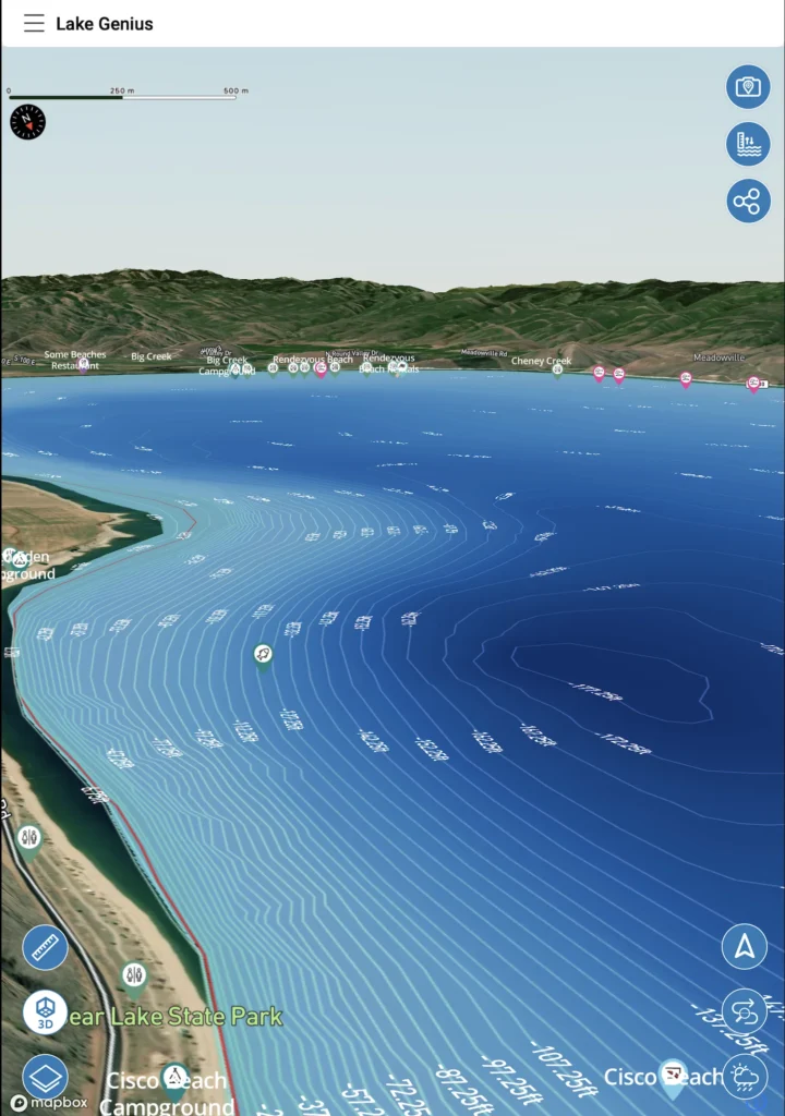
Open Lake Genius and tap the Water Level button to see Lake Havasu’s current reading in feet or meters. The shoreline is highlighted in red on your map so you always know where the water’s edge sits today. The level is measured against Parker Dam operations and updated daily, so the map you’re looking at reflects current conditions, not a static snapshot.
Why Lake Havasu's Water Level Still Matters
Lake Havasu doesn’t swing the way Powell or Mead do. It holds relatively steady through the year because Parker Dam manages a consistent pool. But “steady” isn’t “static.” Spring runoff from the upper Colorado, summer drawdown for downstream water rights, and weekly dam-operation fluctuations all move the level a few feet at a time.
On a lake defined by shallow flats and uneven depths, with deep channels in one stretch and sand inches below the surface in the next, that small movement is exactly what exposes the rocks, old townsite debris, and flats around Topock Gorge that have caught plenty of props and hulls. Checking today’s level tells you which of those flats are close to the surface right now.
How Lake Genius Tracks Lake Havasu's Water Level
The red shoreline
Lake Genius draws the current waterline in red on your map. As the level moves with Parker Dam operations, the red shoreline moves with it, so you can see exactly where the edge of the water is today.
The water level reading
Tap the Water Level button for the current reading in feet or meters. It’s the same number serious Havasu boaters check before deciding where to run the shallow channels.
The underwater view adjusts automatically
Everything beneath the surface is referenced to the current level. When the level changes, the X-Ray View recalculates so the depth contours and 9-foot hazard zone reflect today’s water, not last week’s.
Pro Tip: Check the Level Before You Launch
Cell service drops once you’re into Topock Gorge or the deeper southern coves. The water level updates daily, so pull the latest reading while you still have coverage near Lake Havasu City, and then your downloaded map and X-Ray View work offline for the rest of the day.
Lake Havasu's Water Level Story
Lake Havasu sits on the Colorado River between Lake Havasu City and Parker Dam, and that dam is the whole reason the lake stays as consistent as it does. Parker Dam holds a relatively stable pool to serve downstream water rights, so unlike the dramatic multi-year declines upstream at Powell and Mead, Havasu’s story is one of small, predictable movement: up a little with spring runoff, down a little through summer drawdown, and a weekly wobble from day-to-day dam operations.
For boaters, the takeaway is simple. You don’t need to worry about the lake disappearing, but you do need to know where today’s few feet put the flats.
What Changing Water Levels Mean for Your Lake Havasu Trip
Launching and loading
Havasu’s public ramps (Site Six, Havasu Riviera’s ramp, Windsor Beach at Lake Havasu State Park) handle the normal range well, but knowing today’s level helps you pick the right ramp and avoid a long walk back to the trailer.
Channel and cove access
The Bridgewater Channel, Topock Gorge, and the hundreds of southern coves all have spots where depth changes fast. Today’s level tells you which channels and coves you can run and which to take slow.
Underwater hazards
Submerged rocks, old townsite debris, and shallow flats sit close to the surface in places, especially around Topock Gorge. As the level drops a few feet, more of that comes into the danger zone. The X-Ray View highlights hazards within 9 feet of the surface at the current level.
Anchoring and beaching
Picking a cove to beach for the afternoon? The current level tells you how much sand you’ll actually have and where the drop-off is, so you’re not re-floating the boat when the level nudges down.
Water Levels
+
the X-Ray View
The water level reading and the X-Ray View work together. The level sets where the surface is; the X-Ray View shows you the terrain beneath it, with depth contours and the 9-foot hazard zone recalculated daily against the current level. On a lake where the difference between a deep channel and a prop-eating flat can be a single foot, that connection is the point.
TESTIMONIALS
What Boaters Are Saying
This app is awesome
This app is awesome. So amazing to have easy access to the hazards. Hard to find anything like this.
— PontoonFanboy
- App Store
So much more peace of mind
So much more peace of mind…Totally worth it.
— Whoopwhoop26
- App Store
This app is amazing!
This app is amazing!…so much to see we didn’t know about. This app has changed our entire experience. We can’t go without it now.
— FR6
- App Store
Frequently Asked Questions
What is the current water level at Lake Havasu?
What is the current water level at Lake Havasu?
Lake Genius tracks Lake Havasu’s water level daily. Open the app, tap the Water Level button, and see the current reading in feet or meters, with the red shoreline adjusted to today’s level.
Does Lake Havasu's water level change much?
Does Lake Havasu's water level change much?
Lake Havasu stays relatively steady year-round compared to lakes like Powell or Mead. Parker Dam holds a fairly consistent pool, but spring runoff, summer drawdown, and weekly dam operations still move the level a few feet, enough to matter around the shallow flats.
How often does Lake Genius update the Lake Havasu water level?
How often does Lake Genius update the Lake Havasu water level?
Daily. Each update recalculates the X-Ray View and redraws the red shoreline so the underwater terrain you see reflects today’s conditions.
What controls Lake Havasu's water level?
What controls Lake Havasu's water level?
Parker Dam, at the south end of the lake, manages releases for downstream water rights. That’s what keeps Havasu more stable than the big upstream reservoirs.
Can I check Lake Havasu's water level offline?
Can I check Lake Havasu's water level offline?
Pull the latest reading while you have coverage near Lake Havasu City. It updates daily, so one check covers your day. Your downloaded map and X-Ray View then work offline through Topock Gorge and the southern coves.
Where can I see the red shoreline for today's level?
Where can I see the red shoreline for today's level?
It’s drawn right on the Lake Havasu map in the app. The red line marks today’s waterline and moves as the level changes.
Know Before You Go
Parker Dam keeps Havasu steady, but the flats around Topock Gorge don’t forgive a few feet. Lake Genius tracks the level daily, redraws the shoreline, and shows you what’s near the surface right now.
Start your free trial · No credit card · Works offline