
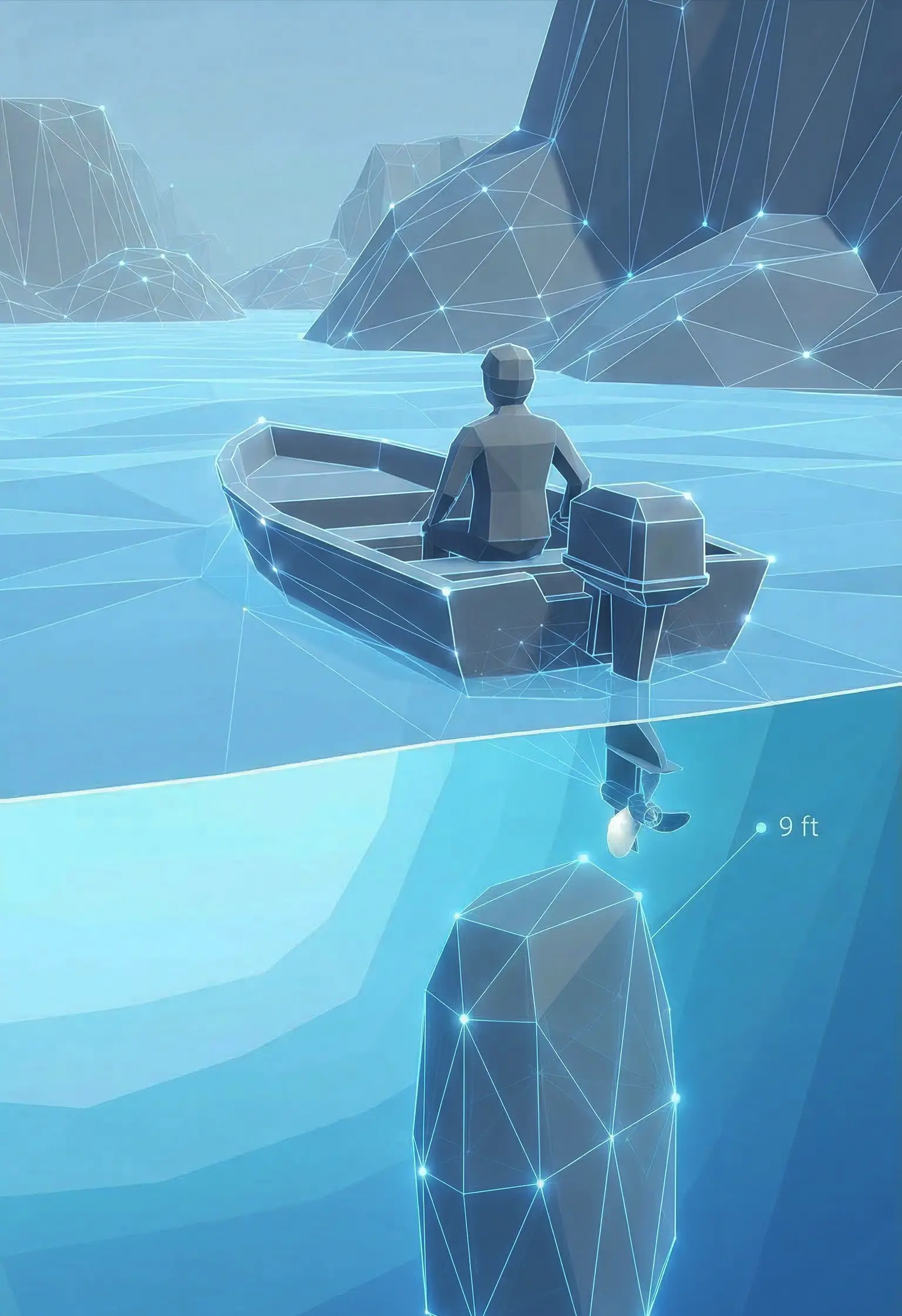
The X-Ray View – See Underwater Hazards Before They Cost You Thousands
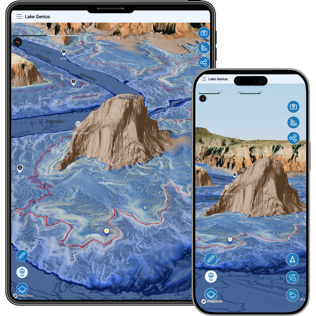
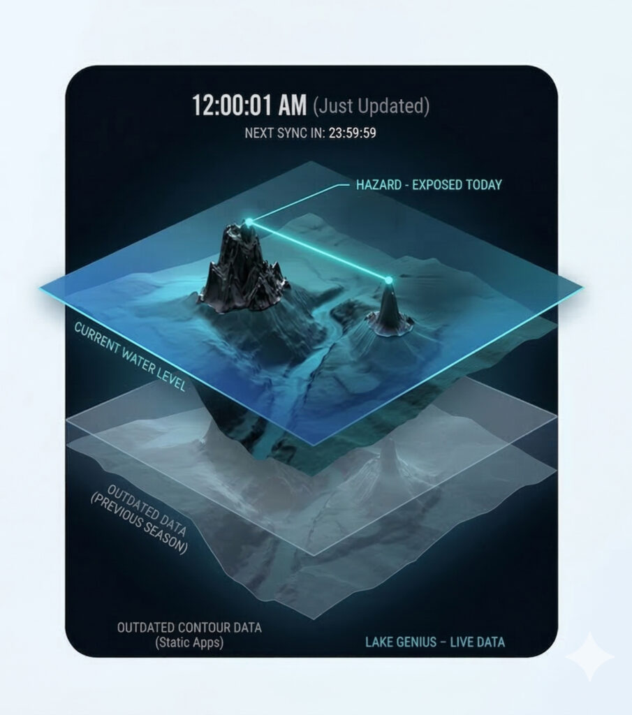
Lake Genius’s signature feature. As you zoom into any area of the lake, a simulated X-Ray View reveals the underwater terrain beneath the surface – showing rocks, ledges, and hazards that could damage your boat, your propeller, or ruin your trip. Updated every night at midnight, so you’re always seeing today’s conditions.
No other boating app updates underwater hazards daily for Lake Powell, Lake Mead, Bear Lake, Lake Tahoe, Lake Roosevelt, and Lake Pleasant.


Start your free trial · No credit card required
How the X-Ray View Works
The X-Ray View combines daily water level data with detailed underwater terrain mapping to show you exactly what’s beneath the surface at each lake.
Open the app and navigate to any area of the lake
The map loads with a standard satellite or terrain view showing the water surface.
Zoom in
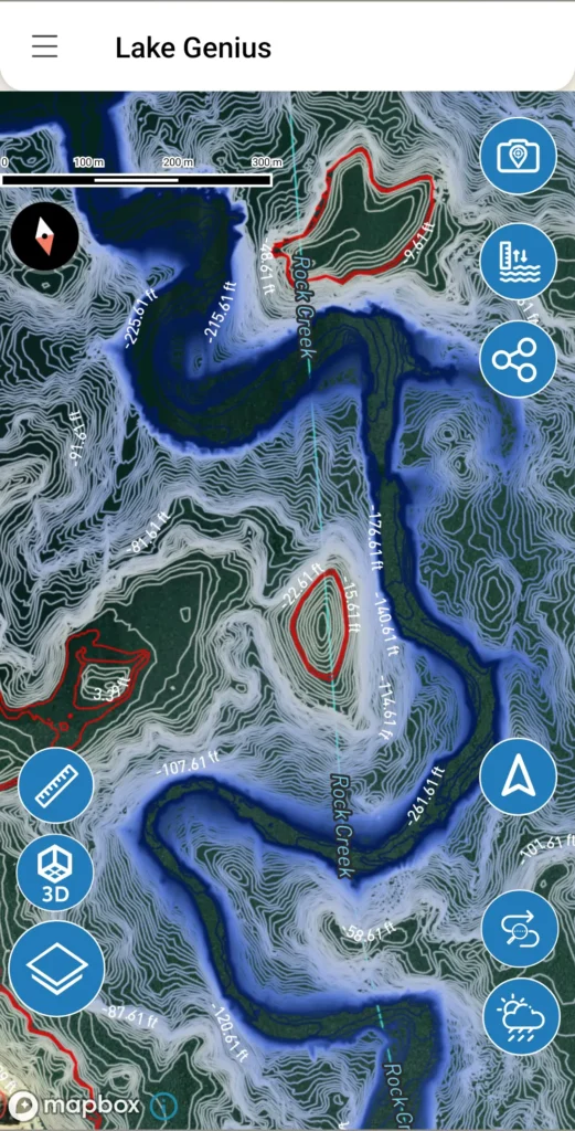
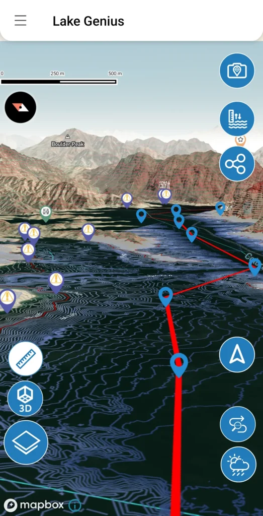
As you zoom closer, the X-Ray View activates automatically. The map transitions into a 3D visualization of the underwater terrain – showing the contours, depth, and shape of the lake floor beneath you.
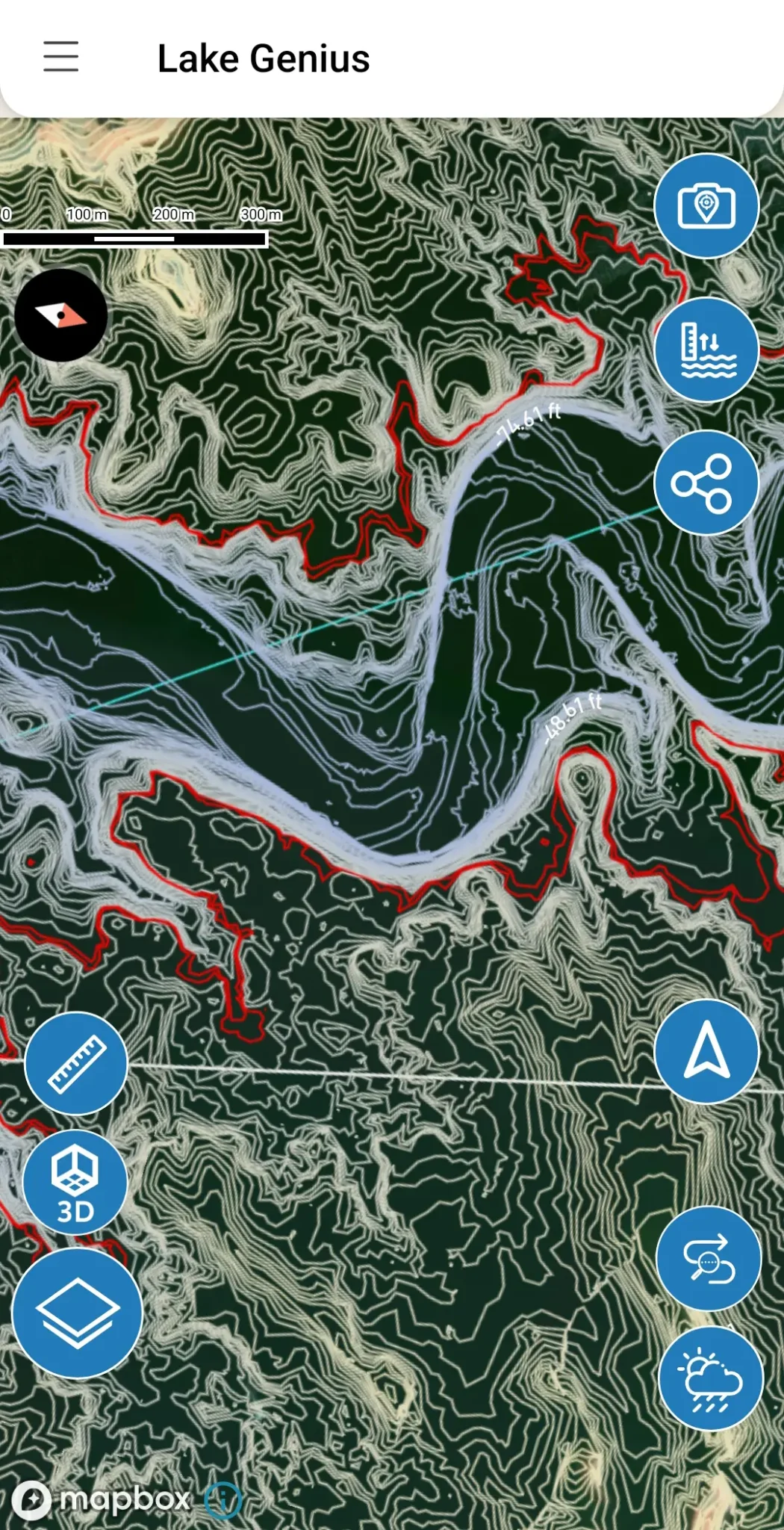
Look for the red shoreline
The current water boundary is highlighted in red, so you always know exactly where the water ends today – not where it was last month or last year.
Spot the hazards.
Rocks, ledges, and submerged terrain within 9 feet of the water surface are visible in the contour view. These are the hazards most likely to damage your hull, propeller, or drive system.
Plan around them.
Use the X-Ray View from home before your trip, or on the water in real time. Mark spots to avoid, plan safer routes, and navigate with confidence.
Technical Detail
Why 9 Feet Matters
The X-Ray View highlights hazards within 9 feet of the water surface. That’s not an arbitrary number – it’s the zone where real damage happens.

Propellers and hulls operate in this range
Most recreational boats and houseboats have hulls and drive systems that extend several feet below the waterline. A submerged rock at 7 feet can destroy a propeller or crack a hull.

Wave swells push boats deeper
On a large open lake, wave action can push your boat several feet lower than its resting draft. A hazard that looks safe in calm water becomes dangerous in chop.

Water sports add risk
Surfers, skiers, and tubers behind your boat are pulled through the water at lower depths. A submerged ledge at 6 feet is a serious danger for anyone in the water.
UPDATED DAILY – NOT LAST MONTH’S DATA
Updated Every Night at Midnight
Water levels at Lake Powell, Lake Mead, Bear Lake, Lake Tahoe, Lake Roosevelt, and Lake Pleasant change constantly – sometimes by 10’s of feet in a single season. As levels drop, hazards that were safely underwater last week can sit just below the surface today.
Static contour maps and generic boating apps can’t show you this. They rely on data that may be weeks, months, or years old. By the time you’re on the water, the lake has moved on.
The Lake Genius X-Ray View updates automatically every night at midnight. When you open the app in the morning, you’re seeing today’s underwater conditions – with the current water level and the current shoreline reflected on your map.
The Cost of What You Can’t See
Underwater hazard damage is one of the most common and expensive problems boaters face at Lake Powell, Lake Mead, Bear Lake, Lake Tahoe, Lake Roosevelt, and Lake Pleasant. Our team has visited boat repair shops from Utah to Las Vegas to Phoenix, and the numbers are consistent:
$5,000–$10,000+
Is the typical repair bill for hitting a submerged rock or ledge. Propeller replacements, hull repairs, and drive system damage add up fast.
$20,000
Is the cost of a single repair our team documented – a drive system and hull damaged by an underwater hazard at Lake Powell.
Boxes of destroyed propellers
Sit on display at Lake Powell boat rental operations. Hazard damage is that common.
LAKES WE COVER
X-Ray View Coverage: Available On All Lake Genius Lakes
The X-Ray View works across all lakes in the Lake Genius app, with daily updates customized to each lake’s conditions and data resolution.
Lake Powell
The most dramatic water level changes of any lake we cover. Ninety-six canyons and 2,000 miles of shoreline mean there’s always somewhere new to explore – and always new hazards to watch for. The X-Ray View is most critical here.
Lake Mead
Well-documented water level drops have reshaped the underwater landscape at Lake Mead. Hazards that were deep underwater a few years ago now sit near the surface. Daily updates help you navigate safely whether you’re launching from Callville Bay or heading to Cottonwood Cove.
Bear Lake
Bear Lake is smaller and generally less hazardous than Powell or Mead, but the X-Ray View still provides underwater terrain visibility and depth contours for safer navigation – especially for boaters unfamiliar with the lake.
Lake Tahoe
Lake Tahoe’s underwater terrain drops off sharply near shore, with granite boulders and rocky shelves sitting just below the surface in areas that look safe from above. The X-Ray View maps near-shore terrain on both the California and Nevada sides, updated daily.
Lake Roosevelt
It stretches 150 miles through eastern Washington, with water levels that swing significantly season to season – regularly exposing submerged terrain in areas that were navigable weeks earlier. The X-Ray View’s offline capability is especially critical here, where cell service disappears well before you reach the upper lake.
Lake Pleasant
Lake Pleasant’s desert terrain creates rocky, irregular underwater structure throughout the main basin and Agua Fria arm – the kind of hazards that aren’t obvious from the surface. The X-Ray View gives Phoenix-area boaters a clear picture of what’s beneath them before they get close to it.
Lake Havasu
45 miles of Colorado River, from Lake Havasu City down to Parker Dam. Hundreds of hidden coves, the famous Bridgewater Channel, and some of the busiest summer boating in the West. Lake Genius maps the channels, marinas, and quiet anchorages, with daily underwater hazard updates and offline maps for when cell service drops in Topock Gorge.
Flaming Gorge
Carved through red rock canyons along the Utah-Wyoming border, Flaming Gorge is a 91-mile reservoir famous for trophy lake trout and dramatic, season-driven water level swings. Lake Genius tracks those changes daily and maps every marina, ramp, and cove, so you navigate the canyons and find the fishing without guessing what’s beneath you.
Mohave
67 miles of Colorado River between Hoover Dam and Davis Dam, with 237 miles of shoreline, canyon hot springs, and the quieter water boaters head to when Lake Mead gets crowded. Water levels move daily with dam operations, and Lake Genius tracks every change — so you know which ramps are open and what’s under the water before you launch.
Our Data
Where the Data Comes From
The X-Ray View combines multiple data sources to create an accurate picture of what’s beneath the water:
Government bathymetry collections providing baseline underwater terrain data
LIDAR and sonar data for detailed depth mapping
Onsite manual data collection by our team at each lake
Daily water level readings from official monitoring sources
These sources are processed using our proprietary method to generate the X-Ray View visualization and daily updates. Each lake has different data resolution based on available data, the lake’s profile, and how boaters use it.
TESTIMONIALS
What Boaters Are Saying
We’ve taken several family houseboat trips to the lake in years past. We normally relied on maps.
I was happy to find an affordable electronic option when I learned of Lake Genius, so downloaded it and subscribed prior to our trip in mid-October 2025. Looking at the app at home I was impressed with the amount of detail concerning elevations and landmarks. In use on the lake, I had a hard time finding a zoom level that would show me both buoy locations and enough elevation / depth information to be useful while underway, but recent updates have fixed that. We found the app very useful overall and a great value.
— DonJ60
Rarely do I leave reviews on apps, but this is an absolute must have in Lake Powell!!
Thank you for an awesome app to help with boating —especially with Lake Powell newbies like us. Heck, even my long time Lake Powell buddies thought this was amazing.
— Mxracer317
- Lake Powell
This app is awesome!
Such a great way to spot underwater hazards easily on your phone. Saves you a lot of hassle and money from hitting your prop on a rock!
— Liv.ballam
Frequently Asked Questions
How does the X-Ray View work?
How does the X-Ray View work?
As you zoom into any area of the lake in the Lake Genius app, the map transitions into a 3D visualization of the underwater terrain. It shows the shape of the lake floor, elevation contours, and the current water boundary highlighted in red. Hazards within 9 feet of the surface are visible so you can navigate around them.
How often are underwater hazards updated?
How often are underwater hazards updated?
The X-Ray View updates automatically every night at midnight. When you open the app, you’re seeing today’s water level and today’s hazard positions – not data from weeks or months ago.
What data sources does Lake Genius use?
What data sources does Lake Genius use?
The X-Ray View is built from government bathymetry data, LIDAR, sonar, onsite manual collection, and daily water level readings. These sources are combined using our proprietary processing method to generate accurate daily visualizations.
Why is the 9-foot threshold important?
Why is the 9-foot threshold important?
Most recreational boat propellers and hulls operate within several feet of the surface. Wave swells can push a boat deeper than its resting draft, and water sports participants are pulled through the water at lower depths. The 9-foot zone is where most real-world damage happens.
How much does boat propeller damage typically cost?
How much does boat propeller damage typically cost?
Boat repair shops across the region report that propeller damage, hull damage, and drive system repairs from hitting underwater hazards typically cost $5,000–$10,000 or more. Our team has documented a single repair that cost $20,000.
Does the X-Ray View work offline?
Does the X-Ray View work offline?
Yes. Once you’ve downloaded the maps for your lake, the X-Ray View works offline. The underwater terrain visualization is included in the downloaded map data. To get the latest daily update, you’ll need an internet connection before heading out.
Is the X-Ray View available on all lakes?
Is the X-Ray View available on all lakes?
Yes. The X-Ray View is available on Lake Powell, Lake Mead, Bear Lake, Lake Tahoe, Lake Roosevelt, Lake Pleasant, and all new lakes added to the Lake Genius app. Each lake has different data resolution based on available data and the lake’s characteristics, but all three receive daily updates.
See What’s Under the Water
The X-Ray View is included in every Lake Genius subscription and available during your free trial. Download the app, zoom into your favorite lake, and see for yourself what’s been hiding beneath the surface.
Start your free trial · No credit card · All lakes · $19.99/year