Lake Tahoe Water Level – Updated Daily in the Lake Genius App
Lake Tahoe sits at over 6,200 feet above sea level. Its water level moves with snowpack, drought cycles, and seasonal runoff – and those changes affect where you can launch, how deep the water is in the coves you want to explore, and how close submerged rocks sit to the surface.
Lake Genius updates Lake Tahoe’s water level daily. Open the app, see where the shoreline sits right now – in feet or meters – and head out knowing what’s under the water before you leave the dock.


What's the Water Level at Lake Tahoe Today?
The Lake Genius app pulls Lake Tahoe’s water level data daily from government sources and updates the map automatically. The current shoreline displays in red so you always know the exact water boundary – no guesswork.
To check the level:
- 1. Open Lake Genius and navigate to Lake Tahoe
- 2. Tap the Water Level button
- 3. See the current level in feet or meters – your preference
- 4. The red shoreline updates to match today's conditions
Why Lake Tahoe's Water Level Matters for Boaters
Lake Tahoe’s water level is driven by snowpack and managed through the dam at Tahoe City. In high snow years, the lake rises closer to its legal maximum; in drought years, it drops and exposes rocky shoreline edges, shallows near coves, and areas that look plenty deep from the surface.
For boaters, those changes matter in a few key ways:
Tahoe's most beautiful spots – Emerald Bay, Secret Cove, Sand Harbor, Cave Rock – involve anchoring or slow-speed maneuvering near rocky shorelines. When the water level moves down even a few feet, submerged rocks in these areas sit closer to the surface than you'd expect. Knowing today's level helps you read those spots accurately before you pull in.
Some launch ramps around the lake become shallow or partially unusable at lower water levels. Checking current conditions before trailering your boat to the lake saves a wasted trip.
Anglers targeting Tahoe's Mackinaw (lake trout) or kokanee salmon need to know where the thermocline sits relative to the surface. Lake Genius lets you manually adjust the water level display to scout structure at your target depth – a tool serious Tahoe anglers use before they ever wet a line.
How Lake Genius Tracks Lake Tahoe's Water Level
Here’s how the daily update works:
Government bathymetry data from trusted federal and state sources provides the baseline depth map for the lake.
Proprietary processing by the Lake Genius team aligns that data with daily water level readings.
The map updates automatically every day – the red shoreline and depth contours reflect today’s conditions.
Download the maps before your trip and the app works fully offline – no cell coverage required once you’re on the water.
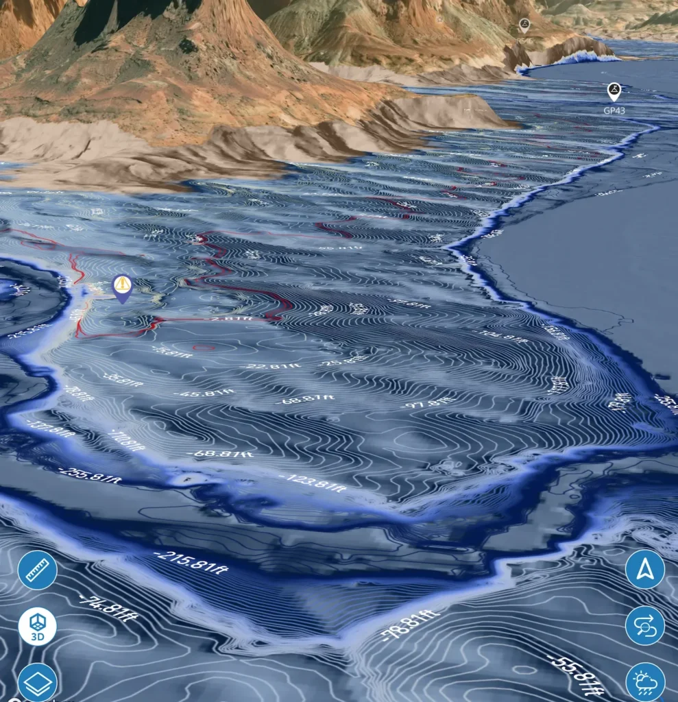
Water Level Drives the X-Ray View
Lake Genius’s X-Ray View overlays 3D depth contours directly on the map as you navigate the lake. The water level reading is what makes that view accurate – because it determines where today’s hazards sit relative to the surface.
At Lake Tahoe, that means:
Zoom in on any cove or anchoring area and see the underwater terrain in 3D
The X-Ray View highlights anything within 9 feet of the current water surface – the zone where boat hulls, props, and water sports participants operate
he red shoreline shows exactly where the water ends today – not where it was last season.
Tahoe’s legendary clarity makes it tempting to judge depth by eye. The X-Ray View gives you the full picture even in areas where the color of the water doesn’t tell the whole story.
When the Water Level Moves,
Here's What Changes
Level moves lower
Rocky shoals near coves sit closer to the surface. Some ramps become shallower. Shoreline anchoring spots narrow.
Level moves higher
Water reaches further into coves and canyon walls. Beaches narrow. Some normally visible rocks become submerged.
Seasonal low (late summer/fall)
Can be 6+ feet lower than spring peak. Spots that were easy to access in June require more care in September.
Post-drought recovery
Water level rises quickly but underwater terrain hasn’t changed – new submerged areas need to be treated with care.
Pro Tip: Check Before You Leave Wi-Fi
Download the Lake Tahoe maps at home or at your cabin before you head to the water. Cell coverage on Lake Tahoe is inconsistent, especially in the southern basin and around Emerald Bay. Once the maps are downloaded, the full app works offline – depth contours, X-Ray View, POI markers, and your saved spots all load without a connection.
The water level update happens daily. Check it at home the night before your trip and you’ll launch with a clear picture of today’s conditions.
TESTIMONIALS
What Boaters Are Saying
TESTIMONIAL PLACEHOLDER #1
A testimonial about the overall app experience — ideally from a boater who used multiple features on a single trip. Example: someone who planned from home, used the X-Ray View on the water, and found a hidden cove via POI. Should convey “this app changed how I experience the lake.”
— John
- Bear Lake
TESTIMONIAL PLACEHOLDER #1
A testimonial focused on hazard avoidance or money saved — someone who spotted a hazard before it became a problem. Connects to the X-Ray View and water levels features. Should convey “this paid for itself immediately.”
— Steve
- Bear Lake
TESTIMONIAL PLACEHOLDER #1
A testimonial about offline reliability or trip planning from home — especially relevant for families or houseboat renters. Should convey “I was confident even in areas with no cell service” or “we planned the whole trip before we left.”
— Gabrielle
- Lake Powell
Frequently Asked Questions
What is the current water level at Lake Tahoe?
What is the current water level at Lake Tahoe?
Lake Tahoe’s current water level is tracked daily in the Lake Genius app. The app pulls data from government sources and updates automatically – open the app, tap the Water Level button, and see today’s level in feet or meters.
How deep is Lake Tahoe?
How deep is Lake Tahoe?
Lake Tahoe has a maximum depth of approximately 1,645 feet, making it the second-deepest lake in the United States. Average depth is around 989 feet. For boaters, the more relevant question is how deep specific coves, anchoring areas, and near-shore spots are – that’s exactly what the Lake Genius X-Ray View shows.
What elevation is Lake Tahoe?
What elevation is Lake Tahoe?
Lake Tahoe sits at approximately 6,229 feet above sea level at its legal rim. The lake’s surface elevation moves slightly throughout the year based on snowpack and seasonal runoff. The Lake Genius app displays the current water level daily so you always know where the surface sits relative to its historical range.
Why does Lake Tahoe's water level change?
Why does Lake Tahoe's water level change?
Lake Tahoe’s level is driven primarily by Sierra Nevada snowpack. In heavy snow years, spring snowmelt raises the lake toward its legal maximum. In drought years or late in the season, the level moves lower – exposing more rocky shoreline and changing conditions in shallow coves. The lake’s outflow is regulated through the dam at Tahoe City.
Does Lake Genius work at Lake Tahoe without cell service?
Does Lake Genius work at Lake Tahoe without cell service?
Yes. Download the Lake Tahoe maps before your trip and the full app works offline – depth contours, X-Ray View, POI markers, your saved spots, and GPS tracking all work without a cell connection. Water level updates and weather require a connection when those features are accessed.
Does the app cover both the California and Nevada sides of Lake Tahoe?
Does the app cover both the California and Nevada sides of Lake Tahoe?
Yes – Lake Genius covers the full lake regardless of state boundaries. Whether you’re launching from South Lake Tahoe, Sand Harbor on the Nevada side, Tahoe City, or Kings Beach, the depth map, X-Ray View, and POI markers cover the entire lake.
See Lake Tahoe's Water Level in the App
Download Lake Genius free and explore Lake Tahoe’s depth map, water level display, and X-Ray View during your fully-featured free trial – no credit card required.
See what’s under the water before you leave the dock.
Free trial · No credit card required · Works offline