Lake Mohave Map – Depth, Hazards & 500+ POI in Your Pocket
A paper map can show you the outline of Lake Mohave. It can’t show you where the Black Canyon ledges sit near the surface, which mid-lake coves have beach today, or how the shoreline moves with the next dam release. Lake Genius puts all 67 miles – Hoover Dam to Davis Dam, 237 miles of shoreline – on your phone, with daily-updated depth and hazards, and it works offline.


Start your free trial · No credit card · Full offline access
More Than a Paper Map. More Than a Generic App.
A printed map shows one snapshot, not much help on a reservoir whose shoreline breathes with daily releases from two dams. Generic boating apps spread static data across the entire country and price it to match.
Lake Genius is built for Lake Mohave specifically. The map updates daily, redraws the shoreline to the current level, and works fully offline once downloaded, which matters when coverage drops through the canyon.
The Black Canyon section near Hoover Dam runs narrow and deep, with submerged rocks and steep ledges close to the surface. Zoom in and the X-Ray View renders a simulated 3D view of the bottom: depth contours beneath the water, hazards within 9 feet of the surface highlighted, and the current waterline in red. It updates daily, so you see today’s hazards, not last season’s.
237 Miles of Shoreline, Hoover to Davis – All Mapped
Lake Mohave has a split personality: sheer canyon cliffs at the north end, sandy coves through the middle, and the open water above Davis Dam to the south. Lake Genius maps the whole run, including the Black Canyon narrows, the mid-lake coves, the hot-springs canyons below Hoover, and every marina and launch in between, so you always know where you are across all 237 miles of shoreline, online or off.
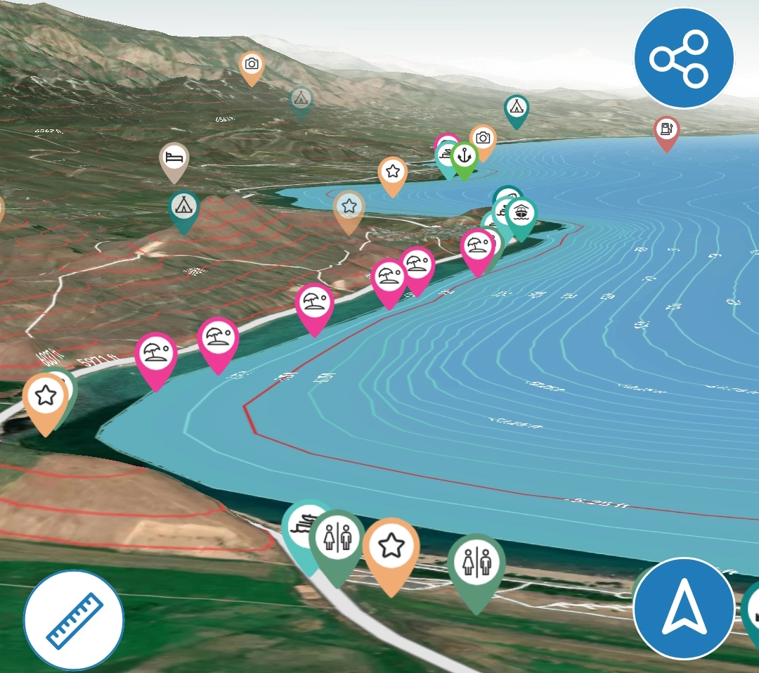
2,000+ Points of Interest – Curated, Not Crowdsourced
Lake Genius carries 2,000+ curated points of interest across every lake it covers, placed by our team rather than crowdsourced. At Lake Mohave, that includes:
Marinas and launch ramps
Katherine Landing (south, full-service, near Bullhead City, AZ), Cottonwood Cove Resort & Marina (mid-lake, Nevada side north of Laughlin), and Willow Beach Marina (north, in the Black Canyon corridor below Hoover). Free launches include Princess Cove, Telephone Cove, and Nelson’s Landing/Placer Cove.
Coves and landmarks
The Black Canyon narrows near Hoover Dam, the hot-springs canyons just below the dam, and the sandy mid-lake coves.
Fishing spots
Trout water near Willow Beach and structure throughout the lake.
Fish Smarter With the Depth Map
Mohave is known for its trout near Willow Beach and structure-holding fish through the canyon and coves. The X-Ray View’s depth contours help you find the ledges, drop-offs, and channel edges where fish stage, and you can adjust the water level in the app to scout how that structure changes. Mark a spot, drop a photo pin, and it’s there next trip.
Download the Map. Use It Everywhere.
Coverage thins out in the canyon between Willow Beach and Cottonwood Cove and along the Arizona shoreline. Download the Lake Mohave map before you launch and the interactive map, X-Ray View, depth contours, POI, GPS navigation, and saved routes all work without a connection. Water level and weather pulls need a brief signal, so grab those at Katherine Landing or Cottonwood Cove first.
Build Your Own Lake Mohave Map
The curated POI are just the start. Drop custom markers on your favorite cove, your trout spot, or the hot spring you want to find again. Snap a photo and the Photo Marker pins it to the map. Share any marker by text, and when they tap the link, the app opens and the marker drops onto their map.
Paper Map vs. Generic App vs. Lake Genius
Capability
Daily underwater hazard updates
Water level–adjusted depth contours
X-Ray View (9-ft hazard zone)
237 mi of shoreline mapped with POI
Works offline (no cell service)
Custom markers and photo pins
GPS tracking on the water
Built specifically for Lake Mohave
Paper Map from the Marina
- No
- No
- No
- Limited
- Yes
- No
- No
- No
Generic Navigation App
- No
- Static
- No
- Generic
- Varies
- Varies
- Yes
- No
Lake Genius
- Yes
- Yes
- Yes
- Yes
- Yes
- Yes
- Yes
- Yes
TESTIMONIALS
What Boaters Are Saying
this app is brilliant for everyone!!
…this app is brilliant for everyone!! It shows hazards, where beaches are coming out and you can even download offline maps. Plus so much more!! It’s worth every penny!!
— boo1214
- App Store
This app is awesome!
This app is awesome! Such a great way to spot underwater hazards easily on your phone. Saves you a lot of hassle and money from hitting your prop on a rock!
— Liv.ballam
- App Store
My go to app
My go to app for boating now!
— RoaringBreeze
- App Store
Frequently Asked Questions
Is there an interactive map of Lake Mohave?
Is there an interactive map of Lake Mohave?
Yes. Lake Genius gives you an interactive Lake Mohave map with underwater terrain, depth contours, marinas, the Black Canyon section, and 2,000+ curated points of interest, on your phone and available offline.
Can I see Lake Mohave's depth on the map?
Can I see Lake Mohave's depth on the map?
Yes. The X-Ray View shows simulated 3D depth contours and highlights hazards within 9 feet of the surface, updated daily against the current water level.
Does the Lake Mohave map work offline?
Does the Lake Mohave map work offline?
Yes. Download the map before your trip and the map, X-Ray View, POI, GPS, and saved routes all work without cell service, which matters in the canyon between Willow Beach and Cottonwood Cove. Water level and weather updates need a brief connection.
Does the map show Lake Mohave marinas and launch ramps?
Does the map show Lake Mohave marinas and launch ramps?
Yes. Katherine Landing, Cottonwood Cove, Willow Beach, and the free launches (Princess Cove, Telephone Cove, Nelson’s Landing) are all mapped with location and services.
Does the map cover the Black Canyon section?
Does the map cover the Black Canyon section?
Yes. The full run from Hoover Dam to Davis Dam is mapped, including the narrow, deep Black Canyon section where submerged rocks sit close to the surface and the offline map matters most.
Can the map help me find fishing spots at Lake Mohave?
Can the map help me find fishing spots at Lake Mohave?
Yes. The depth contours and X-Ray View help you read ledges, drop-offs, and channel edges, and you can save your own spots with custom markers and photo pins.
Get the Map That Knows Lake Mohave
67 miles of river between two dams. 237 miles of shoreline. Depth contours, daily-updated hazards, every marina and cove, in your pocket and offline. Lake Genius turns Lake Mohave into a map you can actually navigate.
Start your free trial · No credit card · Full offline access