Lake Pleasant Water Level – Updated Daily
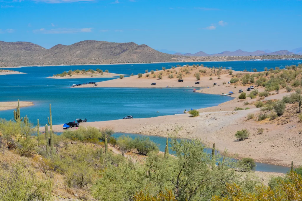
Lake Pleasant moves. The water level here can vary by dozens of feet across a season – and what’s on the surface tells only half the story. Beneath it, reefs, coves, and submerged terrain shift with every change in elevation. Before you load the boat, you need to know where the water actually is today.
The Lake Genius app tracks Lake Pleasant’s water level daily, connects it to underwater terrain data, and shows you what’s beneath the surface in real time – so you can boat confidently, protect your prop, and spend more time exploring and less time guessing.

What Is Lake Pleasant's Water Level Today?
Lake Pleasant’s water level is measured in feet above mean sea level (ft-msl) and is managed by the Central Arizona Project (CAP) and the Maricopa County Parks system. To view today’s water level at Lake Pleasant, download the Lake Genius app, navigate to Lake Pleasant and tap the water level button. The red shoreline updates daily to show today’s conditions and levels.
Unlike natural lakes that follow rainfall patterns, Lake Pleasant is fed by both the Agua Fria River and the CAP canal – which means its levels are influenced by upstream water delivery schedules and regional demand. In practical terms, this means Lake Pleasant can look very different from one visit to the next. When full, the lake reaches up to 260 feet deep at the dam and spreads across more than 10,000 acres. During drawdowns, coves shallow up quickly, boat ramps can shift, and previously safe passages may have underwater obstacles that weren’t there last season.
Seasonal Patterns – What to Expect
- Spring: Levels typically rise as CAP deliveries increase and winter runoff arrives. Higher water opens up more coves and makes ramp access easier.
- Summer: Peak recreational season – also peak demand. Levels can hold steady or begin dropping as irrigation draws increase across the region.
- Fall/Winter: Water is often drawn down for downstream delivery. Shallower coves, exposed reefs, and changed access points are common.
Why Lake Pleasant's Water Level Moves More Than You'd Expect
Lake Pleasant, 35 miles northwest of Phoenix, is a managed reservoir, not a natural desert lake. Held by New Waddell Dam and operated by the CAP, its water level is controlled by more than just rain. CAP pumps Colorado River water into the lake via a 336-mile canal for storage, releasing it based on demand. Natural inflow from the Agua Fria River also contributes, varying with storms.
This management causes water levels to fluctuate drastically—dozens of feet in a single season.
Lake Pleasant’s Seasonal Water Trends:
- Spring/Early Summer: Levels rise due to CAP deliveries and winter runoff. The lake is often at its largest, exceeding 10,000 surface acres and 260 feet deep.
- Mid-Summer/Fall: Levels drop as peak demand draws water down, sometimes quickly. Coves become shallow and rocky; extended boat ramp sections may be needed.
- Monsoon Season (July–September): Summer storms can cause rapid rises in water level from the Agua Fria River watershed.
- Winter: The lake is often at its lowest as CAP manages supply before the next delivery cycle, exposing structure and limiting ramp access.
Lake Pleasant is predictable in that the water level is almost always changing. Checking conditions before visiting is essential.
How Lake Genius Tracks Lake Pleasant's Water Level
Every day, the Lake Genius app pulls the latest water level data for Lake Pleasant from government bathymetric sources and processes it through our proprietary system. Here’s how it works:
Government data sources – including U.S. Bureau of Reclamation gauges and CAP monitoring systems – provide the daily level reading.
Our processing pipeline combines that reading with underwater terrain data (LIDAR, sonar, and onsite collection) to calculate today’s hazard depths.
The app updates daily, giving you a fresh picture of what’s beneath the surface every time you open it.
The current shoreline is highlighted in red on the map – so you always know exactly where the water edge is right now, not where it was last weekend.
What Changing Water Levels Mean for Boaters
Lake Pleasant’s terrain is dramatic – reefs, shallow coves, submerged creek channels, and rocky drop-offs throughout the lake. When the water level moves, so does everything beneath it. What was a clear 6 feet of water yesterday may be a shallow 2 feet today. The hazards don’t move – but your clearance does.
Boat Ramp Access
Both the 10-lane and 4-lane boat ramps can become difficult to use when the lake is drawn down significantly. At low water, the ramp extensions may not reach the waterline. Checking today’s level before you drive out saves you a wasted trip – or worse, launching into conditions your trailer can’t handle.
Cove and Reef Depth
Lake Pleasant has some of the best cove anchoring and swimming spots in Arizona – but many of those coves get very shallow, very quickly when the level drops. Reefs and rocky outcrops that are safely submerged at full pool can become navigation hazards a few feet lower. The Lake Genius app shows you the current depth contours so you know what you’re heading into.
Underwater Hazards Move With the Water
Every rock, reef, and submerged structure in Lake Pleasant exists at a fixed elevation. As the water level moves, so does how close those structures are to the surface. The Lake Genius X-Ray View highlights hazards within 9 feet of the current water surface – and it updates that calculation every day based on today’s reading. A boat that cleared a reef last month may not clear it today.
Fishing Depth
For anglers, water level is everything. Largemouth bass, striped bass, and white bass all move with depth. As the lake drops, fish push to deeper structure. As it rises, they move into shallower cover. The Lake Genius app lets you manually set the water level to scout structure at your target depth – even before you launch.
Lake Pleasant has some of the best bass fishing in Arizona – and knowing the depth helps you find them faster.
Water Level + X-Ray View:
See What's Below
The water level reading doesn’t just tell you how full the lake is – it’s the data that powers the Lake Genius X-Ray View. Every day, when today’s level is applied to our underwater terrain dataset, the app recalculates which rocks, reefs, and structures are within 9 feet of the surface.
Zoom into any area of Lake Pleasant on the map and the X-Ray View shows you the terrain below – depth contours, hazard zones, and the red shoreline boundary – all based on today’s actual water level. Not last week’s. Not last season’s. Today’s.
It’s the closest thing to actually seeing the lake bottom – without getting in the water.
Pro Tip: Check Before You Leave Wi-Fi
Lake Pleasant is located about 35 miles north of Phoenix. Most of that drive has solid cell coverage – but once you’re on the water, you’re often working with limited or no signal, especially on the far ends of the lake.
The best practice: open the Lake Genius app before you leave home or the marina. The app will pull today’s water level update and sync your offline maps – so even if you lose signal mid-lake, you’ve got the latest data on your device. The app continues to work fully offline once maps are downloaded.
Water level and weather features do require a connection when you access them – so grab your update while you still have it.
TESTIMONIALS
What Lake Pleasant Boaters Are Saying
TESTIMONIAL PLACEHOLDER #1
A testimonial about the overall app experience — ideally from a boater who used multiple features on a single trip. Example: someone who planned from home, used the X-Ray View on the water, and found a hidden cove via POI. Should convey “this app changed how I experience the lake.”
— John
- Bear Lake
TESTIMONIAL PLACEHOLDER #1
A testimonial focused on hazard avoidance or money saved — someone who spotted a hazard before it became a problem. Connects to the X-Ray View and water levels features. Should convey “this paid for itself immediately.”
— Steve
- Bear Lake
TESTIMONIAL PLACEHOLDER #1
A testimonial about offline reliability or trip planning from home — especially relevant for families or houseboat renters. Should convey “I was confident even in areas with no cell service” or “we planned the whole trip before we left.”
— Gabrielle
- Lake Powell
Frequently Asked Questions
What is the current water level at Lake Pleasant?
What is the current water level at Lake Pleasant?
Lake Pleasant’s water level is updated daily in the Lake Genius app. Open the app to see today’s reading in feet, including changes from the prior day. Because the lake is managed by the Central Arizona Project and Maricopa County, levels can move throughout the season based on regional water demand.
How deep is Lake Pleasant?
How deep is Lake Pleasant?
At full pool, Lake Pleasant reaches a maximum depth of around 260 feet near the dam. The average depth is approximately 70 feet. In the upstream coves and channels – including the CAP inlet area – the lake gets considerably shallower. The Lake Genius X-Ray View shows depth contours for the areas you’re navigating, updated to today’s water level.
How does Lake Pleasant's water level affect boating?
How does Lake Pleasant's water level affect boating?
As the water level moves, so does the depth over submerged rocks, reefs, and shallow coves. Boat ramp access, cove depth, and hazard clearance all shift with the level. Checking today’s reading before you launch helps you anticipate conditions rather than discover them mid-cove.
When is Lake Pleasant at its lowest water level?
When is Lake Pleasant at its lowest water level?
Lake Pleasant’s lowest levels typically occur in late fall and winter when downstream irrigation demand is highest and CAP deliveries are reduced. Check the Lake Genius app for today’s actual reading before planning your trip – seasonal patterns give you context, but the daily level tells you what’s actually there.
Does Lake Pleasant have boat ramp access at low water?
Does Lake Pleasant have boat ramp access at low water?
Lake Pleasant has both a 10-lane and a 4-lane boat ramp near the main entrance. During significant drawdowns, ramp extensions may not reach the waterline, which can make launching difficult. Always check current water levels before your trip – the Lake Genius app shows today’s level so you can plan accordingly.
Can I use the Lake Genius app offline at Lake Pleasant?
Can I use the Lake Genius app offline at Lake Pleasant?
Yes. Download the Lake Genius offline maps before you leave home or the marina. The app works fully offline for navigation and X-Ray View. Water level and weather features require an internet connection when accessed, so grab your update while you still have signal – then you’re covered for the day.
See Lake Pleasant's Water Level in the App
Before your next trip to Lake Pleasant, open the Lake Genius app and see exactly what the water level is doing – and what’s beneath it. The X-Ray View gives you a look at the underwater terrain, the daily level update shows you current conditions, and the offline maps keep you covered once you’re on the water.
See Today’s Level in the App – Download Free


Free trial · No credit card required · Works offline