Flaming Gorge Water Level – Updated Daily in the Lake Genius App
Flaming Gorge moves with the dam. Seasonal releases and drawdown can shift the shoreline by tens of feet across the year, exposing rocks, ledges, and structure in the canyon arms that were safely underwater a few weeks earlier.


Start your free trial · No credit card · Works offline
Today's Water Level at Flaming Gorge
Open Lake Genius and tap the Water Level button to see Flaming Gorge’s current reading in feet or meters. The shoreline is highlighted in red on your map so you always know where the water’s edge sits today. Flaming Gorge Dam controls the level at the south end, and the reading is updated daily, so the map reflects current conditions, not a static snapshot.
Why Water Levels Matter at Flaming Gorge
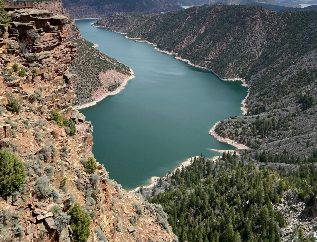
Flaming Gorge is a 91-mile canyon reservoir, and the dam at its south end can move the water by tens of feet over a season. Spring runoff fills it; late-summer and fall drawdown pulls it back down. In the narrow canyon arms, including Red Canyon, Sheep Creek Bay, and Hideout Canyon, that swing is what brings submerged rocks, ledges, and drawdown-exposed structure into the danger zone.
It also changes which ramps you can use. Launches like Buckboard Crossing and Antelope Flat are the most affected by a low reading, so today’s level isn’t just trivia. It decides where you can put in.
How Lake Genius Tracks Flaming Gorge's Water Level
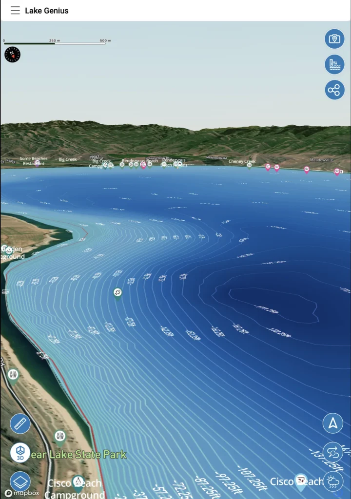
The red shoreline
Lake Genius draws the current waterline in red on your map. As Flaming Gorge Dam moves the level, the red shoreline moves with it, so you can see exactly where the edge of the water is today.
The water level reading
Tap the Water Level button for the current reading in feet or meters, the number to check before you commit to a canyon-arm ramp.
The underwater view adjusts automatically
Everything beneath the surface is referenced to the current level. When the level changes, the X-Ray View recalculates so the depth contours and 9-foot hazard zone reflect today’s water.
Pro Tip: Check the Level Before You Launch
Cell coverage holds at the main marinas (Lucerne Valley, Cedar Springs) but drops through the canyon arms. The level updates daily, so pull the latest reading while you have signal at the marina, and then your downloaded map and X-Ray View work offline across all 91 miles.
Flaming Gorge's Water Level Story
Flaming Gorge is the Green River impounded behind Flaming Gorge Dam, stretching 91 miles from the dramatic red canyons of Utah up into the wider open water of Wyoming. The dam manages the reservoir for water storage, power, and downstream flows, so the level follows a seasonal rhythm: filling with spring runoff, then drawing down through late summer and fall, a swing that can run tens of feet. Understanding that pattern helps you plan around it, whether you’re chasing trophy lake trout in deep water or beaching in a canyon arm.
Multi-year conditions matter too. On a managed reservoir, broader drawdown decisions can leave today’s level sitting well below where it was a season ago, which is exactly when daily updates and the X-Ray View earn their keep.
What Changing Water Levels Mean for Your Flaming Gorge Trip
Launching and loading
Ramps like Buckboard Crossing and Antelope Flat are the most sensitive to a low reading; the marina ramps at Lucerne Valley and Cedar Springs handle more of the range. Today’s level helps you pick a launch that works.
Canyon access
Red Canyon, Sheep Creek Bay, and Hideout Canyon all have sharp drop-offs and tight water. The level affects how much room you have and where the shallow ledges sit, so check before you head into the arms.
Underwater hazards
Submerged rocks, ledges, and drawdown-exposed structure sit close to the surface in the canyons. As the level drops, more of it comes into the danger zone. The X-Ray View highlights hazards within 9 feet of the surface at the current level.
Anchoring and beaching
Beaching in a canyon arm? The current level tells you how much shoreline you’ll have and where the drop-off is, so the drawdown doesn’t strand or float your boat unexpectedly.
Water Levels
+
the X-Ray View
The water level reading and the X-Ray View work together. The level sets where the surface is; the X-Ray View shows you the terrain beneath it, with depth contours and the 9-foot hazard zone recalculated daily against the current level. On a reservoir with sharp canyon drop-offs and structure that emerges as the water falls, that connection is what lets you read the water you can’t see.
TESTIMONIALS
What Boaters Are Saying
So much more peace of mind
So much more peace of mind…Totally worth it.
— Whoopwhoop26
- App Store
This app is awesome
This app is awesome. So amazing to have easy access to the hazards. Hard to find anything like this.
— PontoonFanboy
- App Store
Rarely do I leave reviews on apps
Rarely do I leave reviews on apps, but this is an absolute must have…Thank you for an awesome app to help with boating…
— Mxracer317
- App Store
Frequently Asked Questions
What is the current water level at Flaming Gorge?
What is the current water level at Flaming Gorge?
Lake Genius tracks Flaming Gorge’s water level daily. Open the app, tap the Water Level button, and see the current reading in feet or meters, with the red shoreline adjusted to today’s level.
What controls Flaming Gorge's water level?
What controls Flaming Gorge's water level?
Flaming Gorge Dam, at the south (Utah) end of the reservoir, manages releases for storage, power, and downstream flows. Spring runoff fills the reservoir; late-summer and fall drawdown brings it back down.
How much does Flaming Gorge's water level change?
How much does Flaming Gorge's water level change?
Seasonal releases and drawdown can shift the shoreline by tens of feet over the year, enough to expose canyon structure and affect ramp access, which is why checking today’s level matters.
How often does Lake Genius update the Flaming Gorge water level?
How often does Lake Genius update the Flaming Gorge water level?
Daily. Each update recalculates the X-Ray View and redraws the red shoreline so the underwater terrain you see reflects today’s conditions.
Which Flaming Gorge boat ramps are affected by water levels?
Which Flaming Gorge boat ramps are affected by water levels?
Buckboard Crossing and Antelope Flat are the most sensitive to a low reading. The marina ramps at Lucerne Valley and Cedar Springs handle more of the range. Check today’s level before you drive out.
Can I check Flaming Gorge's water level offline?
Can I check Flaming Gorge's water level offline?
Pull the latest reading while you have signal at a marina. It updates daily, so one check covers your day. Your downloaded map and X-Ray View then work offline through the canyon arms.
Know Before You Go
The dam moves Flaming Gorge by tens of feet a season. Lake Genius tracks it daily, redraws the shoreline, and shows you what’s near the surface right now, from Red Canyon to the Wyoming waters.
Start your free trial · No credit card · Works offline