The Lake Pleasant Map Built for Boaters
Over 10,000 acres of water. More than 100 miles of shoreline. Dozens of coves, two full-service marinas, multiple boat ramps, and underwater terrain that changes with every season.
A paper map of Lake Pleasant won’t tell you where the water is today. A road navigation app doesn’t know what’s beneath your hull. Lake Genius gives you a boating-specific map – built for this lake, updated daily, and loaded with the local detail you need to navigate confidently.
Not a Road Map. Not a Paper Chart. A Boating Map.
Most maps weren’t made for Lake Pleasant boaters. Paper charts sold at the marina are static – they show the lake as it was when they were printed, not as it is today. Road navigation apps are built for pavement; they have no underwater data and no awareness of how the lake moves.
Lake Genius is different in three important ways:
Updates
Underwater view
Points of Interest
Works offline
Marinas & ramps
Paper Charts
- Printed once – static
- None
- Basic, printed
- Yes (it's paper)
- Some
Road Nav Apps
- Road-focused, no lake data
- None
- Generic, road-based
- Limited
- Unreliable
Lake Genius
- Daily – reflects current water level
- X-Ray View with depth contours
- Curated lake-specific markers
- Full offline download
- Verified, with current access context
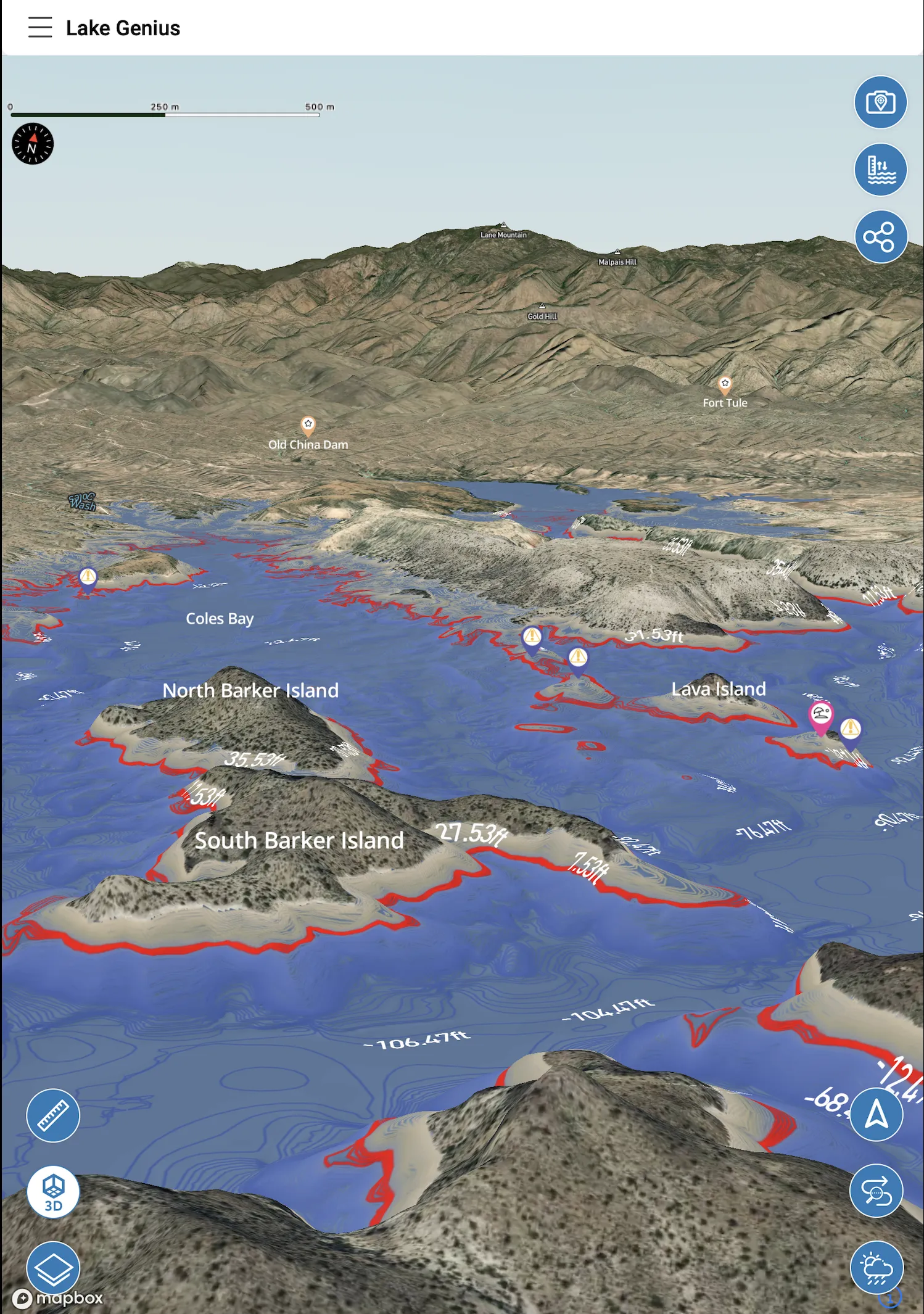
More Than Water Levels – See What's Under the Water
Lake Pleasant’s water level can swing dramatically from season to season. As the lake drops through summer, underwater features that were safely submerged in spring – rocky ledges, submerged points, shallow cove edges – can move within a few feet of the surface.
Lake Genius’s X-Ray View shows you the underwater terrain beneath the map. Zoom into any area of the lake and the 3D contour visualization appears, highlighting depth contours and flagging features within 9 feet of the current water surface. The shoreline is displayed in red so you always see where the water actually is today.
It’s the kind of awareness that used to require a local guide or years of experience on the lake. Now it’s in your pocket before you leave the ramp.
10,000 Acres of Desert Reservoir – More Than the Main Basin
Most people know Lake Pleasant from the main basin near the two marinas. But the lake extends much further than the busy weekend stretch between Pleasant Harbor and Scorpion Bay – and the terrain changes dramatically as you move north.
The Main Basin
The widest, deepest section of the lake. This is where both marinas sit and where most day visitors spend their time. The underwater terrain here includes rocky drop-offs and submerged structure that moves in and out of the hazard zone as water levels change through the season. It’s open water, which means wind can build quickly in the afternoon.
The Agua Fria Arm
Follow the Agua Fria River channel north and the lake narrows into canyon terrain. This arm is one of the most popular fishing areas on the lake – bass relate to the submerged creek channels, rocky points, and depth transitions along the narrowing walls. It’s also one of the first areas to show the effects of a dropping water level, with shallow spots emerging faster here than in the deeper main basin.
Castle Creek and the western coves
The western shoreline is dotted with coves that offer sheltered anchoring and some of the best swimming spots on the lake. Many of these coves are only practical to access by water, and their depth changes significantly with the water level. A cove that’s perfect at high pool may be rocky and shallow by late summer.
The upper lake and dam area
New Waddell Dam anchors the south end, and the water near the dam is the deepest on the lake – over 260 feet at full pool. The terrain drops steeply here, and the underwater structure is less varied than the cove-rich northern and western sections.
Lake Genius maps the full lake – every arm, cove, and stretch of shoreline – with underwater terrain data, daily depth contours, and curated POI markers. Whether you’re fishing the Agua Fria Arm or anchoring in a western cove for the afternoon, the map covers your specific section of the lake with the detail you need.
Find Every Marina and Ramp – Without the Guesswork
Lake Pleasant has two full-service marinas and multiple public launch points spread around the lake. Lake Genius marks all of them – so you can plan your launch, your fuel stop, and your exit before you ever leave home.
Marinas
- Pleasant Harbor Marina: Full-service marina on the northwest shore. Boat rentals, fuel, a restaurant, and an RV resort. One of the primary access points for day visitors and overnight guests.
- Scorpion Bay Marina: Comprehensive services including boat slips, rentals, a restaurant, and a store. Well-equipped for a wide range of watercraft.
Public Launch Ramps
- 10-Lane Boat Ramp: High-capacity public ramp with extensive launch facilities – a strong choice on busy weekends.
- Desert Tortoise Road Launch Ramp: Quieter option on the southeastern side of the lake, popular with anglers and smaller boats.
- Additional ramps: Several MCRD-managed access points around the lake – all marked in the app.
Knowing which ramp is closest to where you want to spend the day – and which ones are accessible at the current water level – is exactly what the Lake Genius map is built for.
Find Your Spot – Then Come Back to It Every Time
Lake Pleasant’s 100+ miles of shoreline hides a lot of great anchoring spots. Sandy beaches tucked into desert coves. Protected inlets away from the main channel. Calm stretches of water perfect for swimming, paddling, or just spending the afternoon.
The problem is finding them – and remembering where they are next time. Lake Genius solves both.
Explore the map from home
Before you leave, browse the Lake Pleasant map and scout coves that look promising. Check the X-Ray View to confirm the depth at your preferred anchoring spots based on today’s water level. Identify your primary destination and a backup – in case the first one is crowded or shallower than expected.
Save what you find
Drop a custom marker on the coves and beaches you want to remember. Name it, choose an icon, and it lives on your map permanently. Next season, next trip – your spots are exactly where you left them.
Share with your crew
Found a great spot mid-trip? Share the marker via SMS. Your crew taps the link, opens the app, and the marker lands on their map automatically. No verbal directions, no trying to describe landmarks on the water.
Fish Smarter With a Depth Map That Updates Daily
Lake Pleasant is known for largemouth bass, white bass, striped bass, channel catfish, and crappie. The Agua Fria Arm and Castle Creek Cove are regularly cited as premier fishing locations – but the fish move with the water, and the water moves with Waddell Dam operations.
A static depth chart tells you where structure was. The Lake Genius map tells you where it is today – adjusted for the current water level.
How anglers use Lake Genius at Lake Pleasant:
- Scout structure from home: Use the X-Ray View to identify submerged points, ledges, and drop-offs before you get on the water. These are the spots bass and stripers use as seasonal water levels change.
- Adjust for depth manually: Tap the water level control to explore what specific structure looks like at different elevations. Useful for targeting fish at exact depth ranges.
- Mark your best spots: Drop a custom marker on productive fishing areas – name it, note the conditions, and build your own private map over time.
- Photo Marker: Snap a photo of a rock formation, submerged tree line, or shoreline feature and pin it to the map. Visual reference right alongside your location data.
Build Your Own Lake Pleasant Map
The Lake Genius map comes loaded with curated markers for marinas, ramps, coves, and fishing areas – but the best map of Lake Pleasant is the one you build yourself over time.
Drop unlimited custom markers
Found a cove with perfect anchoring depth? Mark it. Spotted a reef to avoid at low water? Tag it. Any location on the lake can become a saved marker with a custom name and icon. Your markers stay on your map permanently – trip after trip, season after season.
Photo Marker
Take a photo of anything you want to remember – a rock formation that marks a cove entrance, a shoreline feature near your favorite fishing point, a scenic spot you want to come back to – and the app pins it to the map at your current GPS location. Visual reference, right next to your depth and terrain data.
Share with your crew
Heading out with friends or family? Share any marker via text message. They tap the link, the app opens, and the marker drops onto their map automatically. No coordinates to copy, no landmarks to describe. Just tap and share.
Lake Pleasant regulars know the lake changes with the seasons. A cove that’s your go-to anchoring spot in spring may be too shallow by September. Your custom markers combined with the daily-updated depth contours give you the full picture every time you visit – your personal knowledge layered on top of current conditions.
Cell Service Is Inconsistent Out There. Your Map Doesn't Have to Be.
Cell coverage around Lake Pleasant can be spotty, especially in the more remote coves and the upper portions of the Agua Fria Arm. If you’re relying on a live data connection to navigate, you may be planning around gaps in coverage rather than where you actually want to go.
Lake Genius works fully offline. Download the Lake Pleasant map before you leave home – takes just a few minutes on Wi-Fi – and every feature is available on the water with no cell service required.
What works offline:
- Full Lake Pleasant map with all POI markers
- X-Ray View and depth contours
- Your saved custom markers and routes
- Water level data from your last update
What needs a connection:
- Daily water level refresh (update before you launch)
- NOAA weather notices
The best practice: check the current level and download any map updates before you leave Wi-Fi. Once you’re on the water, you’re covered.
Paper Chart vs. Generic App vs. Lake Genius
Capability
Daily water level updates
Underwater terrain & depth contours
Hazard detection (9-ft zone)
Marinas, ramps & fishing spots
Cove depth at current water level
Custom markers & photo pins
Works offline on the water
Built specifically for Lake Pleasant
Paper Chart
- Static
- No
- No
- A few labeled
- No
- No
- It's paper
- Generic AZ map
Generic Navigation App
- No lake-level data
- No underwater data
- No
- Road directions only
- No
- No
- Requires cell connection
- Worldwide / generic
Lake Genius
- Updated daily via USBR/CAP data
- X-Ray View, recalculated daily
- Highlights hazards near surface
- Curated POI with lake context
- Depth adjusts with daily level
- Unlimited + shareable via text
- Full offline after download
- Purpose-built for this lake
Lake Pleasant can swing dozens of feet in a season. Any map that doesn’t account for today’s water level is showing you a different version of the lake than the one you’re actually on. Lake Genius updates daily – because the lake does too.
TESTIMONIALS
What Boaters Are Saying
TESTIMONIAL PLACEHOLDER #1
A testimonial about the overall app experience — ideally from a boater who used multiple features on a single trip. Example: someone who planned from home, used the X-Ray View on the water, and found a hidden cove via POI. Should convey “this app changed how I experience the lake.”
— John
- Bear Lake
TESTIMONIAL PLACEHOLDER #1
A testimonial focused on hazard avoidance or money saved — someone who spotted a hazard before it became a problem. Connects to the X-Ray View and water levels features. Should convey “this paid for itself immediately.”
— Steve
- Bear Lake
TESTIMONIAL PLACEHOLDER #1
A testimonial about offline reliability or trip planning from home — especially relevant for families or houseboat renters. Should convey “I was confident even in areas with no cell service” or “we planned the whole trip before we left.”
— Gabrielle
- Lake Powell
Frequently Asked Questions
Is there a boating map for Lake Pleasant?
Is there a boating map for Lake Pleasant?
Yes. Lake Genius includes a full-featured Lake Pleasant boating map with daily-updated water levels, underwater depth contours via X-Ray View, curated points of interest including marinas and boat ramps, and offline download capability.
How deep is Lake Pleasant?
How deep is Lake Pleasant?
Lake Pleasant’s depth varies significantly based on the current water level, which can swing up to 125 feet in a typical year based on Central Arizona Project dam operations. The Lake Genius X-Ray View shows current depth contours updated daily so you can see underwater terrain relative to today’s water level.
Where are the boat ramps at Lake Pleasant?
Where are the boat ramps at Lake Pleasant?
Lake Genius marks all publicly accessible boat ramps at Lake Pleasant, including the 10-Lane Boat Ramp and the Desert Tortoise Road Launch Ramp. Both Pleasant Harbor Marina and Scorpion Bay Marina also offer launch access. All are pinned on the Lake Genius map.
Does the Lake Pleasant map work without cell service?
Does the Lake Pleasant map work without cell service?
Yes. Download the Lake Pleasant map before your trip and the full app – including X-Ray View, POI markers, and your saved custom spots – works completely offline. Water level and weather data requires a brief internet connection to refresh, so check both before you leave Wi-Fi.
Can I find fishing spots on the Lake Pleasant map?
Can I find fishing spots on the Lake Pleasant map?
Yes. Lake Genius includes fishing-relevant POI markers and the X-Ray View to help you identify submerged structure, drop-offs, and depth transitions where bass, stripers, and catfish hold. You can also drop custom markers on productive spots and build your own private fishing map over time.
See It in Action Before Your Next Trip to Lake Pleasant
Lake Pleasant rewards boaters who know the lake – the right coves, the right depth, the right spots for the season. Lake Genius helps you build that knowledge before you ever pull into the ramp.
Browse the map. Explore the underwater terrain. Find your spots. Download it all for offline use. Then show up ready.


Start your free trial today. No credit card required.