Lake Powell Water Level – Updated Daily in the Lake Genius App
Lake Powell’s water level moves every day. When it drops, rocks and ledges that were safely submerged last week can sit just below the surface today. When it rises, canyons and coves that were unreachable open back up. Either way, you need to know what the lake looks like right now – not last month.
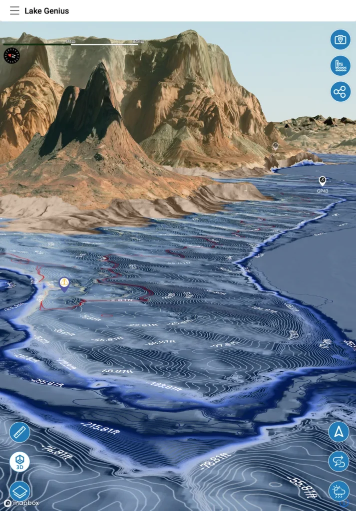
Lake Genius tracks the water level at Lake Powell daily and reflects it directly on your map. The current shoreline is highlighted in red, and the underwater terrain view adjusts automatically so you’re always seeing today’s conditions.


Start your free trial · No credit card · Works offline

Today's Water Level at Lake Powell
Lake Powell’s water level is measured in feet above sea level, and it moves based on snowpack runoff from the Rocky Mountains, seasonal inflows from the Colorado River, evaporation, and regulated water releases downstream to Lake Mead. The number can move a few inches in a day and several feet across a month – enough to change what’s safely navigable and what isn’t.
Lake Genius updates that reading every day. Open the app, tap the Water Level button, and you’ll see the current level in feet or meters – your choice in settings. The shoreline is highlighted in red on your map, so you can see exactly where the water meets the sandstone right now. Not where it was last month. Not where someone predicted it would be. Where it actually is today.
Why Water Levels Matter More at Lake Powell Than Almost Anywhere Else
Lake Powell has experienced some of the most dramatic water level changes of any reservoir in the country. That’s not just a headline – it’s something you’ll deal with every time you launch.
When the water level drops even a few feet, everything underwater moves with respect to the surface. Rocks and ledges that were 15 feet down last week might be 9 feet down today – right in the zone where your prop, hull, and anyone being towed are at risk. Shoreline you anchored at a few days ago might be dry ground now. The cove you explored last trip could be too shallow to enter.
When levels rise, it’s the opposite story. Areas that were too shallow open up again. Previously beached boats can float. But the underwater terrain is still there, and if you’re navigating based on memory from your last visit, you’re guessing.
This is why checking the water level before you head out isn’t optional at Lake Powell. It’s the first thing you do.
How Lake Genius Tracks Lake Powell’s Water Level
Lake Genius pulls water level data daily and applies it directly to your Lake Powell map. Here’s what that looks like in practice:
The red shoreline
Open the app, zoom in and you’ll see the current water boundary highlighted in red on the map. This isn’t a static line drawn once – it updates with the water level data, so the shoreline you see reflects where the water actually is today.
The water level reading
Tap the Water Level button to see the current level in feet or meters (your choice in settings). It’s the same measurement the Bureau of Reclamation reports, processed and displayed in a format that’s immediately useful.
The underwater view adjusts automatically
This is the part most people don’t realize. The water level data feeds directly into the X-Ray View – Lake Genius’s signature underwater hazard detection. As the level moves, the X-Ray View recalculates which rocks, ledges, and terrain are within 9 feet of the surface. You’re not just seeing a number. You’re seeing what that number means for your specific route.
Pro Tip: Check the Level Before You Launch
Here’s the best way to use water level data at Lake Powell:
Before you leave your hotel, rental, or campsite – anywhere you still have Wi-Fi or cell service – open Lake Genius and check the current water level. That data is now on your device for the day. The red shoreline, the water level reading, and the X-Ray View calculations are all based on that number.
Once you’re on the water (where Lake Powell has little to no cell service), the app uses the last known water level. Since levels typically move gradually – a few inches to a couple of feet over the course of a week – your morning check gives you accurate, reliable data for the entire day.
Think of it like checking the weather before you drive to the ramp. You don’t need a live satellite feed updating every second. You need today’s conditions, and that’s exactly what Lake Genius gives you.
Lake Powell’s Water Level Story
Lake Powell’s water level has moved dramatically over the past two decades. Extended drought, reduced snowpack, and competing water demands across the Colorado River basin have driven some of the most significant fluctuations of any reservoir in the West. At times, the lake has dropped well over 100 feet from its high-water mark – exposing terrain, hazards, and even historical sites that hadn’t been visible in decades.
For boaters, the history matters less than what’s happening right now. A chart showing last year’s levels won’t tell you whether that favorite cove is navigable today, or whether the shortcut between two canyons is suddenly too shallow. That’s the gap Lake Genius fills: not historical data for researchers, but today’s conditions for people on the water.
What Changing Water Levels
Mean for Your Lake Powell Trip
Launching and loading
Water levels affect ramp access at every Lake Powell marina. At lower levels, some ramps close entirely or require longer drives to the water. Knowing the level before you plan your launch point saves time and frustration on arrival.
Canyon access
Lake Powell’s 96 canyons are what make it one of the most unique boating destinations in the country. But not every canyon is accessible at every water level. Some narrow side canyons become too shallow to enter when levels drop, while others open up as levels rise. The app’s 800+ curated Lake Powell points of interest are mapped with this in mind.
Underwater hazards
This is the big one. As levels move, the underwater landscape changes with respect to the surface. Rocks and ledges shift in and out of the hazard zone – the top 9 feet where your boat, prop, and passengers are at risk. The X-Ray View uses the daily water level to calculate which hazards are close to the surface right now.
Anchoring and beaching
Where you pull up matters. A sandy beach at one water level might be a rocky ledge a few days later. Checking the red shoreline on the app before you anchor helps you find a safe, accessible spot.
Water Levels
+
the X-Ray View
Knowing the water level at Lake Powell is useful on its own. But it gets significantly more powerful when paired with the X-Ray View – Lake Genius’s signature underwater hazard detection feature.
The X-Ray View uses today’s water level to calculate exactly which rocks, ledges, and submerged terrain are within 9 feet of the surface – the zone where your prop, hull, and anyone being towed are most at risk. As the water level moves, the hazard picture moves with it. A canyon entrance that was clear last week might have a ledge sitting at 7 feet today. A favorite anchoring cove in Padre Bay might be shallower than you remember.
At Lake Powell, this connection matters more than almost anywhere else. With 96 canyons, 2,000 miles of shoreline, and water levels that have seen some of the most dramatic changes of any reservoir in the country, the underwater landscape relative to the surface is constantly evolving. The X-Ray View takes the daily water level reading and turns it into something you can actually see – a 3D picture of what’s beneath your boat, updated every night at midnight.
Water level tells you the number. The X-Ray View shows you what that number means for where you’re headed.
TESTIMONIALS
What Boaters Are Saying
This app is amazing!
So many hazards at Lake Powell and so much to see we didn’t know about. This app has changed our entire experience. We can’t go without it now.
— FR6
- Lake Powell
It doesn’t matter if you’re a newbie or an old Powell lover, this app is brilliant for everyone!!
It shows hazards, where beaches are coming out and you can even download offline maps. Plus so much more!! It’s worth every penny!!
— boo1214
- Lake Powell
Totally worth it.
So much more piece of mind navigating Lake Powell this year.
— Whoopwhoop26
- Lake Powell
Frequently Asked Questions
What is the current water level at Lake Powell?
What is the current water level at Lake Powell?
Lake Genius tracks the Lake Powell water level daily. Open the app and tap the Water Level button to see the current reading in feet or meters. Best practice: check before you leave Wi-Fi so you have today’s data on the water.
How often are Lake Powell water levels updated in the app?
How often are Lake Powell water levels updated in the app?
Daily. Lake Genius pulls the latest water level data every day and applies it to your map. The red shoreline boundary and the X-Ray View both update based on this data, so you’re always seeing current conditions.
Are Lake Powell water levels rising or dropping?
Are Lake Powell water levels rising or dropping?
Lake Powell’s water level moves based on snowpack, seasonal inflows, and water release schedules. The trend changes throughout the year. The most practical approach is to check the current level in Lake Genius before each trip rather than relying on a trend from last month.
Can I see the Lake Powell water level offline?
Can I see the Lake Powell water level offline?
Yes – with one step. Check the water level while you still have Wi-Fi or cell service, and that data stays on your device. The red shoreline, underwater contour data, and X-Ray View all work offline using the last-downloaded water level. Since Lake Powell has virtually no cell service on the water, this is the recommended approach.
Why do Lake Powell water levels change so much?
Why do Lake Powell water levels change so much?
Lake Powell is a managed reservoir on the Colorado River. Water levels are driven by snowpack in the Rocky Mountains, seasonal inflows, evaporation, and regulated water releases to Lake Mead and downstream users. The combination makes Powell one of the most variable lakes in the West – and daily tracking a practical necessity for anyone on the water.
What is Lake Powell’s elevation?
What is Lake Powell’s elevation?
Lake Powell’s full pool elevation is 3,700 feet above sea level. The actual water surface elevation fluctuates based on inflows and releases. Lake Genius displays the current water surface elevation daily, so you always know exactly where the lake stands.
Know Before You Go
Lake Powell’s water level moves every day – and everything underwater moves with it. Lake Genius gives you today’s conditions on a map you can take anywhere on the lake, even without cell service. Check the level. See the hazards. Explore with confidence.
Start your free trial · No credit card · Full access to Lake Powell