
Daily Water Levels & Depth – Know What’s Below Before You Launch
Lake water levels move constantly – and when they do, everything underneath moves with them. As boaters, we’re left guessing – which hazards are near the surface? Which coves are deep enough to anchor in? Which channels are still passable, and where is the actual shoreline today versus where it was last week? Not having accurate answers to these questions can throw a real damper on your trip to the lake, and even be quite costly.
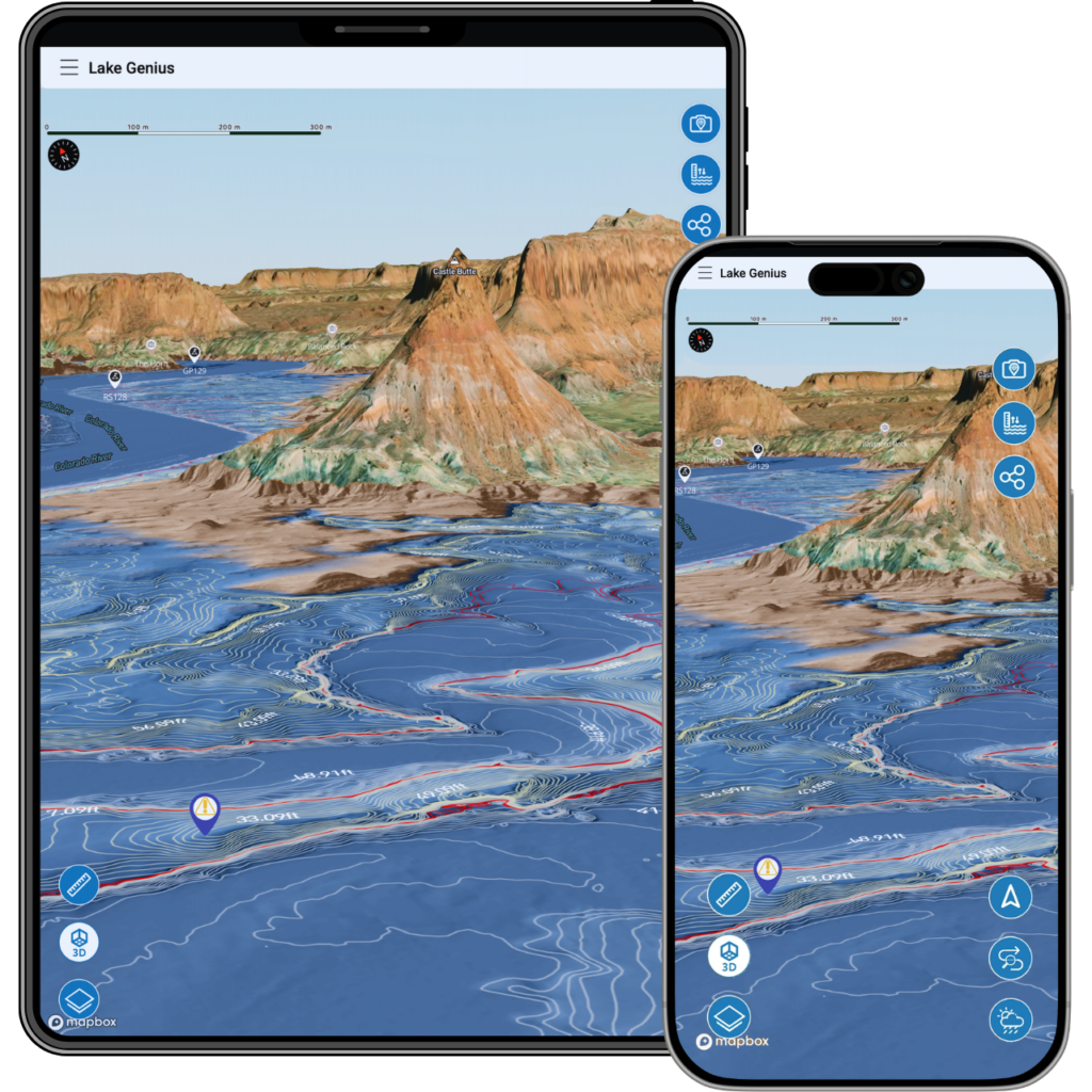
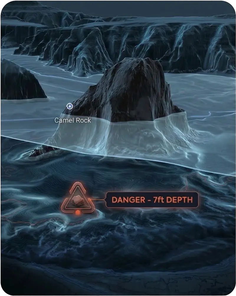
Lake Genius tracks water levels and depth daily for every lake in the app. The current shoreline is highlighted in red on your map. Just tap the Water Level button to see today’s reading in feet or meters. Pair it with the X-Ray View, and you’re looking at a complete picture of what’s happening above and below the surface – updated every day.


Start your free trial · No credit card required
How Water Level Tracking Works
Lake Genius pulls water level data from official monitoring sources and updates every lake in the app daily. Here’s what that looks like on your screen.
Tap the Hazards & Contours button
The app displays the current water level for the lake you’re viewing – shown in feet or meters based on your settings. One tap, one number, no digging.
See the red shoreline on your map
The current water boundary is highlighted in red across the entire lake map. As levels change, the red line moves with them – so you always know where the water actually meets the land today.
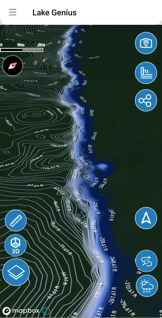
Zoom in for depth detail
Combined with the X-Ray View, water level data helps you see exactly which areas are shallow, which hazards are near the surface, and where it’s safe to navigate. The two features work hand-in-hand – water levels tell you where the surface is, and the X-Ray View shows you how deep it goes from there.
Adjust manually for fishing
Want to see what the lake looks like at a different depth? Lake Genius lets you manually set the water level to explore underwater structure and topography, as well as identify ideal fishing depths – useful for anglers scouting a spot before they ever leave the dock.
Technical Detail
Why Daily Water Level Updates Matter
A water level reading from last week isn’t just outdated – it can be misleading. Here’s why daily matters.
Levels change faster than you’d think.
Lake Powell and Lake Mead are large reservoirs managed by the Bureau of Reclamation. Water releases, seasonal runoff, and drought conditions can shift levels measurably in a matter of days. Over a season, levels can change by tens of feet – completely reshaping what’s safe and what’s not.
Yesterday’s safe passage can be today’s hazard.
A channel that was clear last week may have a submerged rock sitting just below the surface now. A cove that was deep enough to anchor last month might be too shallow today.
Ramp access depends on current levels.
At Lake Powell especially, boat ramp usability changes with the water level. Knowing the current reading before you drive to the lake can save you from arriving at a ramp that’s high and dry.
Paper maps and static apps can’t show any of this.
A contour map printed last year shows last year’s conditions. A boating app that updates monthly – or never – gives you a false sense of where things stand. Lake Genius updates daily because the lake changes daily.
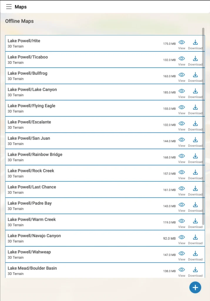
WATER LEVELS BY LAKE
Water Level & Depth Coverage Across Every Lake on Lake Genius
Every lake in the Lake Genius app receives daily water level updates. Here’s what makes each one unique.
Lake Powell
The most dramatic water level story of any lake we cover. Powell’s levels have fluctuated significantly over the past decade, reshaping the shoreline, exposing new hazards, and changing which canyons are navigable season to season. If there’s one lake where daily water level tracking is non-negotiable, it’s Powell.
Lake Mead
Lake Mead’s water level changes have made national headlines. Dramatic drops have revealed everything from submerged boats to previously hidden geological features. For boaters, the practical impact is straightforward: the underwater landscape at Mead has been completely reshaped, and what was deep water a few years ago may be dangerously shallow today.
Bear Lake
Bear Lake is generally more stable than Powell or Mead, but levels still shift with snowpack and seasonal conditions. Daily tracking gives you confidence at the ramp and on the water – especially if you’re visiting for the first time and don’t have a local’s feel for the lake.
Lake Tahoe
Lake Tahoe’s level rises with winter snowpack and falls through the boating season, and the near-shore depth changes meaningfully as it does. Knowing today’s reading matters when you’re navigating granite-lined shorelines where the bottom comes up fast.
Lake Roosevelt
Lake Roosevelt’s water level swings significantly across the year – what’s deep water in summer can be a very different picture by fall. Daily tracking is the only reliable way to know what you’re navigating into on a lake this remote and this large.
Lake Pleasant
Lake Pleasant fills through winter and drops through summer, and levels can shift noticeably within a single season of Phoenix heat. What was deep enough last weekend might not be next – which is exactly what daily water level tracking is built for.
Lake Havasu
45 miles of Colorado River, from Lake Havasu City down to Parker Dam. Hundreds of hidden coves, the famous Bridgewater Channel, and some of the busiest summer boating in the West. Lake Genius maps the channels, marinas, and quiet anchorages, with daily underwater hazard updates and offline maps for when cell service drops in Topock Gorge.
Flaming Gorge
Carved through red rock canyons along the Utah-Wyoming border, Flaming Gorge is a 91-mile reservoir famous for trophy lake trout and dramatic, season-driven water level swings. Lake Genius tracks those changes daily and maps every marina, ramp, and cove, so you navigate the canyons and find the fishing without guessing what’s beneath you.
Mohave
67 miles of Colorado River between Hoover Dam and Davis Dam, with 237 miles of shoreline, canyon hot springs, and the quieter water boaters head to when Lake Mead gets crowded. Water levels move daily with dam operations, and Lake Genius tracks every change — so you know which ramps are open and what’s under the water before you launch.
WORKS OFFLINE AFTER DOWNLOAD
Offline Capability – What You Need to Know
The water level data that powers the red shoreline on your map is included when you download maps for your lake. That means:
Offline
The red shoreline boundary, underwater contour data, and the last-downloaded water level are all available without internet. If you downloaded maps this morning at the hotel, that data is on your device for the day.
Needs internet
To pull the very latest water level reading (the number in feet or meters), the app needs a brief internet connection. Best practice: check the latest level before you leave Wi-Fi range, and you’re covered for the day. The app will use the last known level which could be yesterday, or whenever you last had cellular service.
Better Together: Water Levels + the X-Ray View
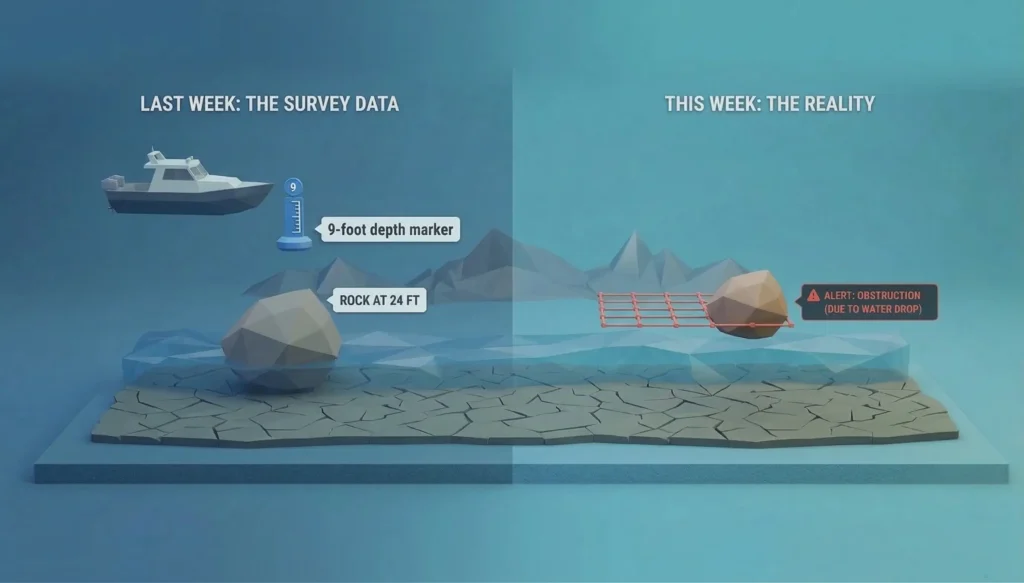
Water level data tells you where the surface is. The X-Ray View shows you what’s beneath it. Together, they give you something no paper map or static app can: a daily-updated picture of what’s actually happening under your boat.
As water levels drop, new hazards emerge near the surface. The X-Ray View uses the current water level to calculate which rocks, ledges, and terrain are within 9 feet of the surface – the zone where real damage happens. Without daily water level data feeding into it, the X-Ray View would be guessing. With it, you’re navigating on today’s information.
TESTIMONIALS
What Boaters Are Saying
We’ve taken several family houseboat trips to the lake in years past. We normally relied on maps.
I was happy to find an affordable electronic option when I learned of Lake Genius, so downloaded it and subscribed prior to our trip in mid-October 2025. Looking at the app at home I was impressed with the amount of detail concerning elevations and landmarks. In use on the lake, I had a hard time finding a zoom level that would show me both buoy locations and enough elevation / depth information to be useful while underway, but recent updates have fixed that. We found the app very useful overall and a great value.
— DonJ60
Rarely do I leave reviews on apps, but this is an absolute must have in Lake Powell!!
Thank you for an awesome app to help with boating —especially with Lake Powell newbies like us. Heck, even my long time Lake Powell buddies thought this was amazing.
— Mxracer317
- Lake Powell
This app is awesome!
Such a great way to spot underwater hazards easily on your phone. Saves you a lot of hassle and money from hitting your prop on a rock!
— Liv.ballam
Frequently Asked Questions
How often are water levels updated in Lake Genius?
How often are water levels updated in Lake Genius?
Water levels are updated daily for every lake in the app. When you open Lake Genius, you’re seeing today’s reading – not data from weeks or months ago. The current shoreline is highlighted in red on your map so you can see where the water boundary is right now.
Can I see water levels in feet and meters?
Can I see water levels in feet and meters?
Yes. Lake Genius displays water levels in feet or meters depending on your settings. Tap the Water Level (Hazards & Contours) button on any lake to see the current reading in your preferred unit.
Do water level updates work offline?
Do water level updates work offline?
Partially. The red shoreline boundary and underwater contour data are included in your downloaded maps, so they work offline. To pull the very latest water level reading, you’ll need an internet connection – so check the current level before heading out, and you’ll have what you need for the day.
Does Lake Genius show water level forecasts?
Does Lake Genius show water level forecasts?
Not currently. Lake Genius shows today’s actual water level based on official monitoring data. Forecast capability may be added in the future, but right now the focus is on giving you accurate, daily-updated current conditions.
What lakes does Lake Genius track water levels for?
What lakes does Lake Genius track water levels for?
Every lake in the Lake Genius app receives daily water level updates. Currently that includes Lake Powell, Lake Mead, Bear Lake, Lake Tahoe, Lake Roosevelt, Lake Pleasant, Lake Mohave and Lake Havasu.
How does the water level affect the X-Ray View?
How does the water level affect the X-Ray View?
The X-Ray View uses the current water level to calculate which underwater hazards are within 9 feet of the surface. As levels change, the hazards that matter change too. Daily water level data is what keeps the X-Ray View accurate to today’s conditions.
Can I manually adjust the water level in the app?
Can I manually adjust the water level in the app?
Yes. Lake Genius lets you manually set the water level to explore what the lake looks like at different depths. Anglers use this to scout underwater structures and identify ideal fishing depths before heading out.
See Where the Water Is Today
Daily water level and depth updates are included with every Lake Genius subscription and available during your free trial. Download the app, tap the Water Level button, and see today’s conditions for yourself.
Start your free trial · No credit card · $19.99/year for all lakes