
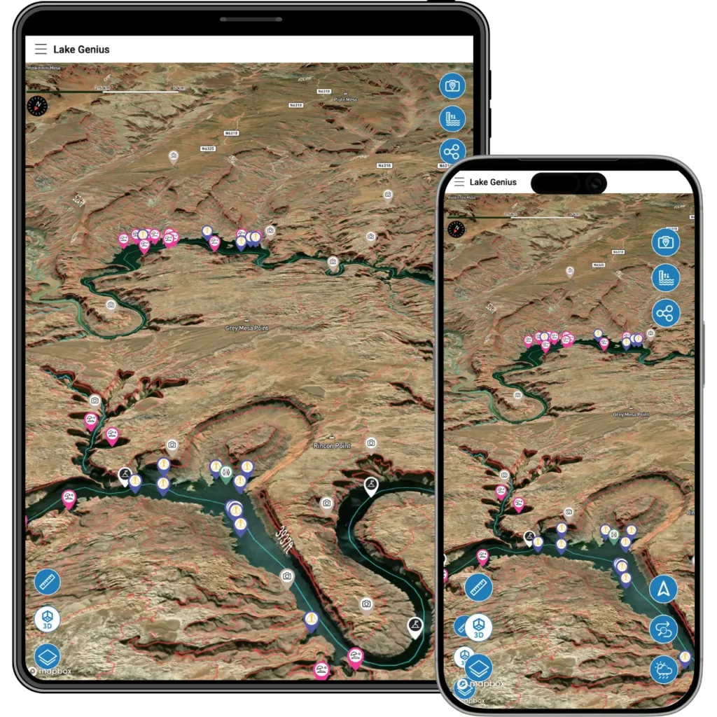
2,000+ Points of Interest – Curated by Local Lake Experts
Marinas. Fuel docks. Hidden beaches. Slot canyons. Petroglyphs. Fishing spots. Hiking trailheads. Every point of interest in Lake Genius has been placed and reviewed by our team – people who’ve spent years on these lakes and know what’s worth finding.
Over 2,000 curated markers across every lake in the app. Tap any one for details, then navigate straight to it – online or offline. No guesswork, no crowdsourced pins dropped by someone who visited once. Just reliable, local knowledge at your fingertips.


Start your free trial · No credit card required
What You’ll Find on the Map
Lake Genius maps the destinations, services, and resources that matter when you’re on the water – and some you’d never find on your own.
Marinas and fuel docks
Every major marina across all lakes in the app is mapped with details and navigation. Know where the fuel is, where to dock, and how to get there – even when you’re offline and miles from the nearest one.
Beaches, coves, and anchoring spots
Secluded sandy beaches tucked into canyons. Calm coves perfect for swimming or anchoring overnight. The kind of spots that take locals years to discover – mapped for you from day one.
Slot canyons
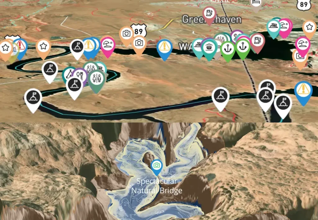
Narrow, cathedral-like passages carved by water over centuries. Some are accessible only by boat, and Lake Genius maps the ones worth exploring – including where to anchor and how to access them.
Petroglyphs and rock art
Ancient rock art sites scattered across Glen Canyon, Lake Mead National Recreation Area, and beyond. Lake Genius marks documented locations so you can find them without wandering past.
Hiking trailheads
Several trails are reachable from the water with a short hike or a nearby parking area. Lake Genius maps the trailheads so you can plan a hike into your boating day – or build a full day around it.
Fishing spots
Whether you’re trolling open water or targeting a specific cove, the POI markers help you find productive spots. Pair them with the X-Ray View to see the underwater structure before you drop a line.
Food, lodging, and facilities
Restaurants, campgrounds, restrooms, and lodging near launch points and marinas. The practical stuff that rounds out a full day – or full week – on the lake.
Natural arches and caves
Sandstone arches and cave formations that make these lakes unlike anywhere else in the country. Lake Genius marks the ones accessible from the water so you don’t motor past them without knowing.
POINTS OF INTEREST YOU CAN TRUST
Curated, Not Crowdsourced
There’s a meaningful difference between a pin dropped by a stranger and a point of interest placed by someone who knows the lake.
Every marker in Lake Genius is curated by our team. We’ve boated these lakes, hiked these trails, fueled at these marinas, and anchored in these coves. The POI data isn’t scraped from a database or submitted by random users – it’s built from firsthand experience and reviewed annually.
What that means for you:
Markers are where they should be – not a quarter-mile off because someone tagged a spot from memory. Descriptions are accurate and practical. Categories are consistent. And the team can update most markers without waiting for a full app release, so the data stays current as conditions change.
We’re not going to tell you we’ve mapped every interesting spot on every lake – there are always more to discover. But the 2,000+ markers in the app are ones we’d stake our name on.
Not Just for Boaters
Lake Genius is a boating app first. But the POI feature opens the door to anyone exploring these lakes – even if they never set foot on a boat.
Hikers scouting trailheads near the water. Photographers hunting for petroglyphs and rock formations. Campers looking for the best beach access points. RV travelers planning stops along lakeside routes. The 2,000+ curated markers give all of them something no generic map app can: local knowledge of places that aren’t on the typical tourist circuit.
That said, the app is built for the water. If you’re a boater who also hikes, fishes, and camps – you’ll find everything in one place.
SITES VS. USER-CREATED MARKERS
Two Kinds of Markers: Ours and Yours
Lake Genius distinguishes between two types of map markers:
Sites & Resource Markers
The 2,000+ markers pre-loaded by the Lake Genius team. These cover marinas, fuel docks, points of interest, trailheads, beaches, and more. They’re maintained and updated by our team.
User-Created Markers
Your personal markers. Save a hidden cove, tag a fishing spot, or mark a beach you want to come back to next year. You choose the icon, name it whatever you want, and it stays on your map until you delete it. Share any marker with friends via text message – they tap the link, the app opens, and the marker lands on their map.
Between the two, you end up with a personalized lake map that combines curated local knowledge with your own discoveries.
BROWSE BY LAKE
Explore Points of Interest by Lake
Every lake in the Lake Genius app has its own curated set of points of interest, tailored to what makes that lake unique.
Lake Powell
The crown jewel of POI coverage. Ninety-six canyons, slot canyons, ancient petroglyphs, hidden beaches, and six mapped marinas – including Wahweap, Antelope Point, Bullfrog, Halls Crossing, Dangling Rope, and Hite. Powell has the most POI density of any lake in the app, and for good reason: there’s more to find here than most people can explore in a lifetime.
Lake Mead
Marinas, beaches, coves, and desert hiking trailheads across a lake that spans the Nevada-Arizona border. Lake Mead’s POI coverage includes Callville Bay, Cottonwood Cove, and access points that cater to the Las Vegas boating crowd as well as dedicated lake travelers.
Bear Lake
Bear Lake’s POI coverage focuses on what brings families and visitors to the Caribbean of the Rockies: beaches, boat ramps, campgrounds, fishing spots, and marina access on both the Utah and Idaho sides. Compact, well-organized, and perfect for a lake where you can see most of it on a weekend.
Lake Tahoe
Marinas, public beaches, boat ramps, and scenic landmarks across a lake that straddles the California-Nevada border. Lake Tahoe’s POI coverage includes Tahoe Keys Marina, Ski Run Marina, Cave Rock, Sand Harbor, and Emerald Bay — with both the California and Nevada shores mapped.
Lake Roosevelt
Campgrounds, historic sites, marinas, and boat-in beaches along 150 miles of eastern Washington shoreline. Lake Roosevelt’s POI coverage includes Keller Ferry, Seven Bays, Fort Spokane, and St. Paul’s Mission — plus the secluded coves and beaches tucked into the lake’s remote upper arms.
Lake Pleasant
Marinas, fishing spots, desert hiking trailheads, and coves spread across a lake that draws the Phoenix area’s boating crowd year-round. Lake Pleasant’s POI coverage includes Scorpion Bay Marina, Pleasant Harbor Marina, and the rocky coves and launch points across the main basin and Agua Fria arm.
Lake Havasu
45 miles of Colorado River, from Lake Havasu City down to Parker Dam. Hundreds of hidden coves, the famous Bridgewater Channel, and some of the busiest summer boating in the West. Lake Genius maps the channels, marinas, and quiet anchorages, with daily underwater hazard updates and offline maps for when cell service drops in Topock Gorge.
Flaming Gorge
Carved through red rock canyons along the Utah-Wyoming border, Flaming Gorge is a 91-mile reservoir famous for trophy lake trout and dramatic, season-driven water level swings. Lake Genius tracks those changes daily and maps every marina, ramp, and cove, so you navigate the canyons and find the fishing without guessing what’s beneath you.
Mohave
67 miles of Colorado River between Hoover Dam and Davis Dam, with 237 miles of shoreline, canyon hot springs, and the quieter water boaters head to when Lake Mead gets crowded. Water levels move daily with dam operations, and Lake Genius tracks every change — so you know which ramps are open and what’s under the water before you launch.
WORKS OFFLINE
Every Marker, Even Offline
All 2,000+ points of interest are included in your downloaded maps. No internet connection required to browse, tap for details, or navigate to any marker on the lake. For Lake Powell – where most of the lake has zero cell service – this is the difference between having a guide and going in blind.
TESTIMONIALS
What Boaters Are Saying
We’ve taken several family houseboat trips to the lake in years past. We normally relied on maps.
I was happy to find an affordable electronic option when I learned of Lake Genius, so downloaded it and subscribed prior to our trip in mid-October 2025. Looking at the app at home I was impressed with the amount of detail concerning elevations and landmarks. In use on the lake, I had a hard time finding a zoom level that would show me both buoy locations and enough elevation / depth information to be useful while underway, but recent updates have fixed that. We found the app very useful overall and a great value.
— DonJ60
Rarely do I leave reviews on apps, but this is an absolute must have in Lake Powell!!
Thank you for an awesome app to help with boating —especially with Lake Powell newbies like us. Heck, even my long time Lake Powell buddies thought this was amazing.
— Mxracer317
- Lake Powell
This app is awesome!
Such a great way to spot underwater hazards easily on your phone. Saves you a lot of hassle and money from hitting your prop on a rock!
— Liv.ballam
Frequently Asked Questions
What types of points of interest does Lake Genius include?
What types of points of interest does Lake Genius include?
Lake Genius maps marinas, fuel docks, slot canyons, petroglyphs, natural arches, caves, beaches, coves, anchoring spots, fishing locations, hiking trailheads, campgrounds, food, lodging, restrooms, and more. Over 2,000 markers across every lake in the app, covering both on-water destinations and shoreside resources.
Are the points of interest crowdsourced?
Are the points of interest crowdsourced?
No. Every marker in Lake Genius is curated by our team – people with years of firsthand experience on these lakes. Markers are reviewed annually and can be updated without a full app release. This is local knowledge, not user-submitted pins.
Can I navigate to a point of interest during my trip?
Can I navigate to a point of interest during my trip?
Yes. Tap any marker on the map for details, then navigate to it. Navigation works both online and offline – download your maps before your trip and every marker is available with no cell service required.
Does Lake Genius show marinas and fuel docks?
Does Lake Genius show marinas and fuel docks?
Yes. Every major marina and fuel dock across all lakes in the app is mapped with details and navigation. At Lake Powell alone, that includes Wahweap, Antelope Point, Bullfrog, Halls Crossing, and Hite marinas.
Can I save my own markers alongside the curated ones?
Can I save my own markers alongside the curated ones?
Absolutely. Lake Genius lets you create unlimited personal markers – tag a fishing spot, mark a hidden beach, save a favorite cove. Your User-Created Markers appear on the map alongside the pre-loaded points of interest, giving you a personalized lake map.
Do the points of interest work offline?
Do the points of interest work offline?
Yes. All 2,000+ curated markers are included in your downloaded maps and fully functional offline – tap for details, navigate, browse by category. No internet connection needed.
How many lakes have POI coverage?
How many lakes have POI coverage?
Every lake in the Lake Genius app has curated points of interest. Currently that includes Lake Powell, Lake Mead, Bear Lake, Lake Pleasant, Lake Roosevelt, Lake Mohave, and Lake Havasu with new lakes being added.
Is Lake Genius useful if I’m not a boater?
Is Lake Genius useful if I’m not a boater?
Lake Genius is designed primarily for boaters, but the POI feature is useful for anyone exploring these lakes – hikers, campers, photographers, fishermen, and RV travelers all benefit from curated markers for trailheads, beaches, campgrounds, and more.
Explore More. Search Less.
Over 2,000 points of interest – marinas, beaches, slot canyons, petroglyphs, fishing spots, and more – all curated by people who know these lakes inside and out. Download Lake Genius, tap the map, and start discovering what’s out there.
Start your free trial · No credit card · $19.99/year for all lakes