Lake Powell Map – Depth, Hazards & 800+ POI in Your Pocket
A paper map from the marina gift shop can tell you the shape of Lake Powell. It can’t tell you where today’s underwater hazards are, where the shoreline actually sits right now, or whether that canyon you want to explore is deep enough to navigate this week.
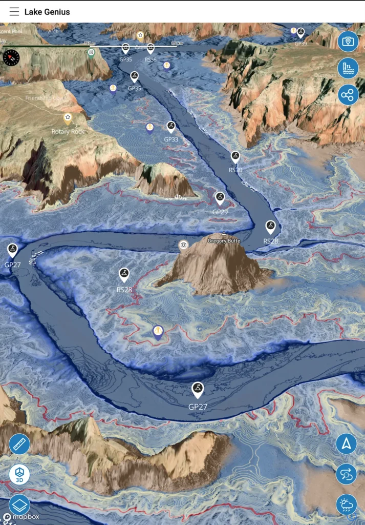
The Lake Genius map does all of that. It’s an interactive, offline-capable map of Lake Powell with underwater terrain visualization, daily hazard updates, 800+ curated points of interest, and GPS tracking – on your phone, ready whenever you need it.


Start your free trial · No credit card · Full offline access
More Than a Paper Map. More Than a Generic App.
If you’ve boated at Lake Powell before, you’ve probably seen the laminated maps for sale at the marinas. They’re fine for getting a general sense of the lake’s shape. But they were printed months or years ago, they show zero underwater data, and they can’t tell you where the shoreline is today versus where it was last week. At a lake where water levels move constantly, a static map is already outdated the day you buy it.
Generic boating apps aren’t much better for Lake Powell specifically. Most are built for coastal and ocean navigation – worldwide coverage, but shallow knowledge of inland reservoirs. They don’t update underwater hazards daily. They don’t map the 96 canyons with the kind of detail you need. And most require a cell connection to work, which makes them useless across the vast majority of Lake Powell.
Lake Genius was built specifically for lakes like Powell. The map updates daily. The underwater terrain is visible. The points of interest are curated by people who know these canyons. And the whole thing works offline once you download it. That’s the difference between a map you look at and a map you actually use on the water.
See What’s Under the Surface
Zoom into any area of the Lake Powell map and the X-Ray View activates – a 3D visualization of the underwater terrain beneath the surface. You’ll see depth contours, elevation changes, and underwater features that most boaters never know are there.
The X-Ray View highlights hazards within 9 feet of the water surface – the zone where your prop, hull, and anyone being towed are most at risk. The current shoreline is shown in red, and the entire underwater picture updates daily based on the latest water level data.
This is what makes the Lake Genius map fundamentally different from anything you’ll find printed on paper or pinned to a marina wall. You’re not looking at a snapshot of the lake from last year. You’re looking at what’s under your boat today.
96 Canyons. All Mapped. All in Your Pocket.
Lake Powell has 96 major canyons stretching across 186 miles of reservoir. Each one has its own character – narrow slot canyons barely wider than your boat, deep side canyons perfect for overnight anchoring, and wide-open bays with sandy beaches that feel like the coast.
The Lake Genius map covers all of them. Every canyon is mapped with points of interest, underwater terrain data, and depth contours. Whether you’re navigating Padre Bay for the first time, threading through the narrow entrance to Labyrinth Canyon, or looking for that hidden beach in Last Chance Bay – it’s on the map with the detail you need to explore confidently.
And because the map works offline, you can pull up canyon details even when you’re miles from the nearest cell signal – which, at Lake Powell, is most of the time.
800+ Points of Interest – Curated, Not Crowdsourced
The Lake Genius map includes over 800 curated points of interest at Lake Powell, covering everything a boater, hiker, or explorer needs to know:
Marinas and services
Wahweap, Bullfrog, Antelope Point, Halls Crossing, and Hite – all mapped with locations and services. Know where fuel, supplies, and pump-out stations are before you need them.
Slot canyons and natural features
Lake Powell is famous for its slot canyons – narrow, cathedral-like passages carved into the Navajo sandstone. The map marks accessible slot canyons along with natural arches, caves, and rock formations you’d never find without a guide.
Petroglyphs and cultural sites
Ancient rock art is scattered across the Lake Powell area. These markers help you find and respect these sites – many of which are only accessible by water.
Beaches, anchoring spots, and camping
The best pull-up beaches, overnight anchoring coves, and shoreline camping areas – all marked by the Lake Genius team, not random user submissions.
Hiking trailheads and access points
Several Lake Powell hikes are only reachable by boat. The map shows where to anchor and where the trails start.
Every marker is placed by the Lake Genius team and reviewed regularly. This isn’t crowdsourced data from users who visited once – it’s curated by people who know these canyons.
Fish Smarter With the Depth Map
Lake Powell is one of the best bass fisheries in the Southwest. Smallmouth bass, largemouth bass, striped bass, walleye, and catfish all live in these waters – and the fish relate to structure. Drop-offs, submerged ledges, canyon walls, creek channels, and rocky points are where the action is. The challenge is that Powell’s dramatic water level changes move the productive zone constantly. The shelf that held fish at 30 feet last month might be the hot zone at 20 feet today.
The Lake Genius depth map shows you that structure. Zoom into any canyon or bay and the X-Ray View renders the underwater terrain – contour lines, depth transitions, and the shape of the lake floor beneath you. You can see where the drop-offs are, where the flats transition to deep water, and where submerged points create the kind of ambush structure that bass and walleye use.
Before you ever launch, use the X-Ray View to explore canyon arms and identify the structure you want to fish. The 3D terrain makes it easy to find the transitions and ledges that produce fish – without burning fuel running the lake.
Tap the water level control to see what the lake looks like at different depths. If you know the bass have been holding at a specific depth range, you can preview where that range intersects with structure across the entire lake. Anglers use this to plan which canyons to target based on current conditions.
Drop custom markers on productive fishing areas – name them, note the conditions, and build your own private fishing map of Lake Powell. The Photo Marker feature lets you snap a photo of a rock formation, a shoreline feature, or a canyon entrance and pin it to the map. Come back next season and find the exact spot without guessing.
With 96 canyons and a water level that rewrites the playbook every season, having a depth map that updates daily isn’t a luxury – it’s the difference between fishing blind and fishing with information.
Download the Map. Use It Everywhere.
Most of Lake Powell has no cell service. That’s not an exaggeration – once you’re past the marina, your phone is on its own. Any map or app that needs an internet connection to function is dead weight.
Lake Genius is built for this. Download the full Lake Powell map to your device before your trip, and every core feature works without a connection: the interactive map, the X-Ray View, points of interest, GPS tracking, saved routes, and your custom markers. It’s all on your device.
Best practice: download the maps while you’re on Wi-Fi, check the latest water level before you launch, and you’re set for the day. Weather and water level pulls require a brief internet connection, but the underlying map and hazard data are fully offline.
Build Your Own Lake Powell Map
The Lake Genius map comes loaded with 800+ curated markers – but you can add your own too. Drop unlimited custom markers anywhere on the map: that perfect sandy beach your kids loved, the fishing spot that always produces, the anchoring cove you want to come back to next year.
The Photo Marker feature takes it a step further. Take a photo of anything you want to remember – a rock formation, a canyon entrance, a fishing spot – and the app marks it on the map with the image attached. You’re building a personalized Lake Powell map that gets better every trip.
Share your markers with other Lake Genius users via text message. Tap share, pick the marker, and the recipient gets it added to their map automatically. It’s the easiest way to pass along your favorite spots to friends or family joining you on the lake.
Paper Map vs. Generic App vs. Lake Genius
Capability
Daily underwater hazard updates
Water level–adjusted depth contours
X-Ray View (9-ft hazard zone)
96 canyons mapped with POI
Works offline (no cell service)
Custom markers & photo pins
GPS tracking on water
Built specifically for Lake Powell
Marina Paper Map
- Printed once, static
- No water level data
- No
- Basic labels on some
- It's paper
- No
- No
- Powell-specific but static
Generic Boating App
- Static or no inland data
- No daily level tracking
- No
- Minimal inland detail
- Most require connection
- No or limited
- Road-focused
- Worldwide / generic
Lake Genius
- Updated every night at midnight
- Adjusts daily to current level
- 3D underwater terrain
- 800+ curated markers
- Full offline after download
- Unlimited + shareable via text
- Lake-specific GPS tracking
- Purpose-built, daily updates
Lake Powell has essentially zero cell service once you leave the marina. That single fact makes most digital tools useless on the water. Lake Genius is built around that reality – download before you launch, and everything works.
TESTIMONIALS
What Boaters Are Saying
This app is amazing!
So many hazards at Lake Powell and so much to see we didn’t know about. This app has changed our entire experience. We can’t go without it now.
— FR6
- Lake Powell
It doesn’t matter if you’re a newbie or an old Powell lover, this app is brilliant for everyone!!
It shows hazards, where beaches are coming out and you can even download offline maps. Plus so much more!! It’s worth every penny!!
— boo1214
- Lake Powell
Totally worth it.
So much more piece of mind navigating Lake Powell this year.
— Whoopwhoop26
- Lake Powell
Frequently Asked Questions
Is there an interactive map of Lake Powell?
Is there an interactive map of Lake Powell?
Yes. Lake Genius provides a fully interactive map of Lake Powell with underwater terrain, depth contours, daily hazard updates, 800+ points of interest, and GPS tracking. It works on your phone and is fully functional offline.
Can I see Lake Powell underwater depth on the map?
Can I see Lake Powell underwater depth on the map?
Yes. The X-Ray View shows a 3D visualization of the underwater terrain as you zoom in. Depth contours are visible, and hazards within 9 feet of the surface are highlighted. The data updates daily based on the current water level.
Does the Lake Powell map work offline?
Does the Lake Powell map work offline?
Yes. Download the Lake Powell map before your trip and it works without any internet connection. The interactive map, X-Ray View, points of interest, GPS, and saved routes all function offline. Weather and water level pulls need a brief connection, but the core map is fully offline-capable.
Does the Lake Genius map show Lake Powell canyons?
Does the Lake Genius map show Lake Powell canyons?
All 96 major canyons at Lake Powell are mapped with points of interest, underwater terrain data, and depth contours. Whether you’re looking for a specific slot canyon, a quiet anchoring cove, or a beach for the afternoon, the map has it covered.
Can I add my own markers to the Lake Powell map?
Can I add my own markers to the Lake Powell map?
Yes. You can drop unlimited custom markers anywhere on the map. The Photo Marker feature lets you attach a photo to any marker. You can also share markers with other Lake Genius users via text message.
Get the Map That Knows Lake Powell
Ninety-six canyons. 800+ points of interest. Daily underwater hazard updates. Full offline access. The Lake Genius map gives you everything you need to navigate Lake Powell with confidence – on your phone, ready when you are.
Start your free trial · No credit card · Full Lake Powell map included