Bear Lake Water Level – Updated Daily in the Lake Genius App
Bear Lake’s water level moves throughout the year. Whether you’re launching from a state park ramp, anchoring in a cove, or scouting a fishing spot – knowing today’s water level helps you plan smarter and boat with confidence.
Lake Genius tracks Bear Lake’s water level daily. Open the app, tap the Water Level button, and see exactly where the water sits right now – in feet or meters, your call.


Start your free trial · No credit card required

Today’s Water Level
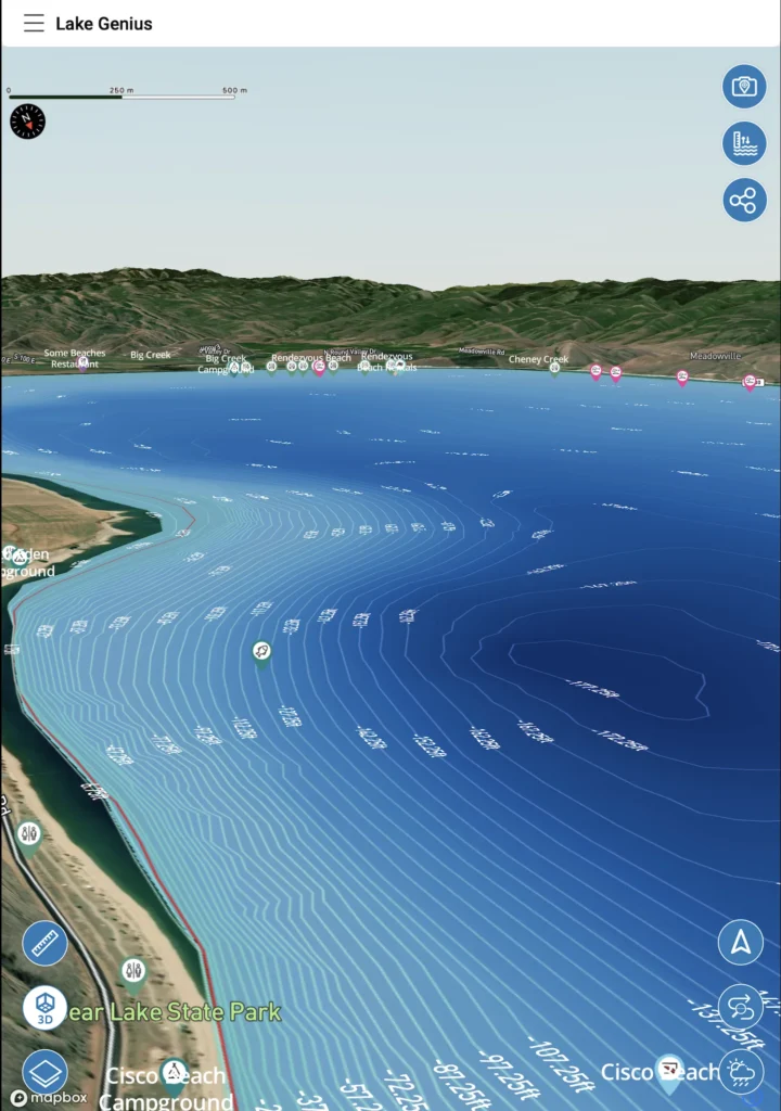
Bear Lake’s water level is updated every day inside the Lake Genius app. Tap the Water Level button to see the current reading, displayed in feet or meters based on your settings. The current shoreline is highlighted in red on your map so you can see exactly where the water boundary is today.
How Bear Lake’s Water Level Works
Bear Lake sits on the Utah-Idaho border at about 5,924 feet elevation. Unlike reservoir lakes that fluctuate dramatically with dam releases and drought cycles, Bear Lake’s water level tends to move more gradually – driven by seasonal snowmelt, irrigation use, and natural inflow from Bear River.
That doesn’t mean the level stays the same. Over the course of a season, Bear Lake can move enough to change where you can safely launch, which ramps are usable, and how much clearance you have over shallow spots near shore. If you visited two weeks ago and the water was at one level, it may not be the same today.
That’s the point of tracking it daily. You don’t need to guess – just check the app before you head out.
How Lake Genius Tracks It
Lake Genius pulls Bear Lake’s water level from official monitoring data sources every day. That reading feeds into the app’s map, adjusting the red shoreline boundary to reflect today’s conditions.
Here’s what happens behind the scenes:
Official data in
Lake Genius receives the latest water level reading from government monitoring sources daily.
Shoreline updates
The red shoreline boundary on your map moves to reflect where the water actually is today – not where it was last season.
Hazard recalculation
The X-Ray View recalculates which underwater features are within 9 feet of the surface based on the new water level.
Your map stays current
Every time you open the app with a connection, you’re seeing today’s Bear Lake – not a static snapshot from months ago.
What Changing Levels Mean for Boaters
Even gradual water level moves at Bear Lake affect your day on the water. Here’s what changes:
Boat ramp access
Some ramps at Bear Lake become shallow or unusable when levels drop. Knowing today’s level before you load the trailer saves you from driving to a ramp that won’t work.
Shallow water near shore
Bear Lake’s popular beaches and coves can get surprisingly shallow when levels are down. The app shows where the water boundary actually is today so you’re not running aground near the spots everyone likes to anchor.
Underwater hazards move
Everything underwater moves in relation to the water level. Rocks and structures that were safely submerged last week might be within striking distance of your hull or prop today. The X-Ray View recalculates daily.
Fishing depth changes
If you’re chasing Bear Lake cutthroat trout or cisco, water level affects where fish hold relative to underwater structure. You can manually adjust the water level in the app to scout depths before heading out.
Pro Tip: Check Before You Leave Wi-Fi
Cell coverage around Bear Lake can be spotty, especially on the Idaho side and along the east shore. Best practice: check the current water level while you still have a Wi-Fi or cellular connection – at your campsite, at the marina, or before you leave town. Once you’ve seen the latest reading, you’re covered for the day.
If you’re already on the water without a connection, the app uses the most recent water level it downloaded. That’s usually yesterday’s reading – close enough for safe navigation. But for the most current data, check before you launch.
Water Levels
+
the X-Ray View
Knowing the water level is useful on its own. But it gets a lot more powerful when paired with the X-Ray View.
The X-Ray View shows you what’s below the surface – a 3D visualization of the underwater terrain with elevation contours and hazards highlighted. It uses today’s water level to calculate which features are within 9 feet of the surface. As the water moves, the hazard map updates. What was safe to cruise over last week might be a prop-scraper today.
At Bear Lake, this is especially useful near popular anchoring coves and along the shallower south end where underwater structure sits close to the surface.
TESTIMONIALS
What Bear Lake Boaters Say
TESTIMONIAL PLACEHOLDER #1
A testimonial about the overall app experience — ideally from a boater who used multiple features on a single trip. Example: someone who planned from home, used the X-Ray View on the water, and found a hidden cove via POI. Should convey “this app changed how I experience the lake.”
— John
- Bear Lake
TESTIMONIAL PLACEHOLDER #1
A testimonial focused on hazard avoidance or money saved — someone who spotted a hazard before it became a problem. Connects to the X-Ray View and water levels features. Should convey “this paid for itself immediately.”
— Steve
- Bear Lake
TESTIMONIAL PLACEHOLDER #1
A testimonial about offline reliability or trip planning from home — especially relevant for families or houseboat renters. Should convey “I was confident even in areas with no cell service” or “we planned the whole trip before we left.”
— Gabrielle
- Lake Powell
Frequently Asked Questions
What is the current water level at Bear Lake?
What is the current water level at Bear Lake?
Lake Genius tracks Bear Lake’s water level daily. Open the app and tap the Water Level button to see today’s reading in feet or meters. The red shoreline on your map shows exactly where the water boundary is right now.
How often are Bear Lake water levels updated?
How often are Bear Lake water levels updated?
Every day. Lake Genius pulls the latest water level data from official monitoring sources daily, and the app’s map updates to reflect the current shoreline and hazard positions.
Is Bear Lake’s water level rising or dropping?
Is Bear Lake’s water level rising or dropping?
It depends on the season and year. Bear Lake’s level moves gradually based on snowmelt, irrigation demand, and natural inflow. Open the app to see today’s reading and compare it to where the shoreline was on your last visit.
How deep is Bear Lake?
How deep is Bear Lake?
Bear Lake reaches a maximum depth of about 208 feet. The Lake Genius app shows underwater depth contours and terrain across the entire lake, so you can see exactly how deep the water is at any point – updated daily with the current water level.
Does the Bear Lake water level work offline?
Does the Bear Lake water level work offline?
Partially. The red shoreline boundary and underwater contour data are included in your downloaded maps, so they work offline. To pull the very latest water level reading, you’ll need a connection – so check before you leave Wi-Fi and you’re set for the day.
Is Bear Lake in Utah or Idaho?
Is Bear Lake in Utah or Idaho?
Both. Bear Lake straddles the Utah-Idaho border, with Bear Lake State Park on the Utah side and additional public access on the Idaho side. Lake Genius covers the entire lake regardless of which state you’re launching from.
See Where the Water Is Today
Daily water level updates are included with every Lake Genius subscription and available during your free trial. Download the app, tap the Water Level button, and see today’s Bear Lake conditions for yourself.
Start your free trial · No credit card · Full access to Bear Lake