Bear Lake Map – Beaches, Depth & Hidden Spots in Your Pocket
Most people show up to Bear Lake with a road map or a phone full of screenshots. That’s fine for finding the highway – but it won’t show you underwater depth, which boat ramps are accessible today, or where the best anchoring coves are.
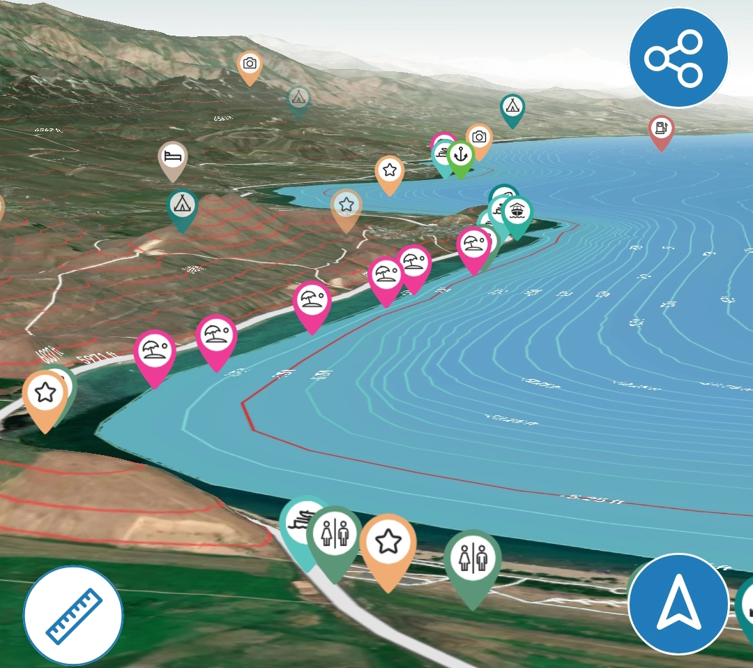
Lake Genius gives you an interactive map of Bear Lake built specifically for people on the water. Underwater terrain, depth contours, 400+ points of interest, beaches, fishing spots, marinas, boat ramps – all in one app. Download it before your trip and it works offline, even in areas with no cell service.


Start your free trial · No credit card required
More Than a Paper Map
A paper map of Bear Lake shows you the outline and maybe a few labeled beaches. A road navigation app shows you how to get to Bear Lake. Neither one shows you what’s under the water, where to anchor safely, or which boat ramp works at today’s water level.
Lake Genius is a different kind of map. It’s built for people who are actually on Bear Lake – not just driving past it. The map updates daily with current water levels, shows underwater terrain and depth contours through the X-Ray View, and includes 400+ curated points of interest covering everything from beaches and fishing spots to campgrounds and boat ramps.
And because it’s designed for lake use, it works offline. Download the Bear Lake maps before your trip, and every core feature works without a cell signal.
Underwater Terrain & Depth Contours
Bear Lake may look calm on the surface, but there’s real structure underneath. The lake reaches about 208 feet at its deepest point, with underwater shelves, drop-offs, and gradual slopes that matter whether you’re fishing, anchoring, or just making sure you have enough clearance.
Zoom in on the Lake Genius map and the X-Ray View activates – a 3D visualization of the underwater terrain with elevation contours. The current water level drives the display, so what you see reflects today’s conditions, not data from a static chart printed years ago. Hazards within 9 feet of the surface are highlighted, and the shoreline is shown in red so you always know where the water boundary is right now.
For anglers chasing Bear Lake cutthroat trout or cisco, the depth contours are especially useful. You can scout underwater structure and drop-offs from shore – or from your couch – before you ever launch the boat. You can also manually adjust the water level in the app to see how different depths change the picture.
Two States. Two Shorelines. The Whole Lake in One Map.
Bear Lake sits on the Utah-Idaho border, and the two sides of the lake feel like different destinations. The west shore on the Utah side is developed and accessible – Bear Lake State Park, Rendezvous Beach, and the marinas are all here. The east shore and the Idaho side are quieter, less developed, and home to some of the best anchoring and fishing the lake offers.
The Utah (west) shore
This is where most visitors start. Bear Lake State Park, the main marina, and Rendezvous Beach are all on this side. The shoreline is sandy in places, with easy access to the turquoise water Bear Lake is famous for. The south end tends to be shallower, with underwater terrain that sits closer to the surface – especially as water levels fluctuate through summer.
The Idaho (north) shore
Cross the state line and the vibe changes. North Beach and Bear Lake State Park (Idaho side) offer public access, but the shoreline is generally less crowded. The northeast corner of the lake has some of the deepest water – Bear Lake reaches about 208 feet at its maximum – and the underwater drop-offs here are steeper and more abrupt.
The east shore
The least developed stretch. Rocky shoreline, fewer access points, and some of the best spots for boaters willing to explore. Coves along the east side are only practical to reach by water, and the underwater structure along this shore is more varied than the wide, sandy west side.
The Lake Genius map covers the entire lake regardless of state lines. Every beach, boat ramp, marina, and cove on both sides is mapped with the same depth data, POI detail, and daily water level updates. You don’t need one map for Utah and another for Idaho – it’s all here.
Fish Bear Lake's Unique Waters With the Depth Map
Bear Lake is one of only a few lakes in the world that supports endemic fish species found nowhere else – the Bear Lake cisco, the Bear Lake sculpin, and a population of Bonneville cutthroat trout that draws anglers from across the West. Lake trout (mackinaw) and whitefish also draw serious fishing attention, especially in deeper water during summer and fall.
Fishing Bear Lake well means understanding its underwater terrain. The lake drops steeply along the east shore, with depth transitions that concentrate fish at specific levels depending on the season. The shallower south end and the flats along the west shore hold different structure – and different fish – than the deep basin in the center.
Scout the depth contours from home
The X-Ray View shows Bear Lake’s underwater terrain in 3D. Before you launch, explore the depth transitions along the east shore drop-offs, the shallow structure near Cisco Beach, and the deeper basin where lake trout hold in summer. Knowing where the terrain changes helps you start your day in the right zone.
Adjust the water level to preview structure
Use the manual water level control to see how different readings affect the depth picture. When the lake drops through summer, structure that was deep enough to ignore in June can become the sweet spot in August. Preview it before you go.
Build your own fishing map
Drop custom markers on your best spots – the ledge where you caught cutthroat, the flat where cisco school in January, the drop-off that produces lake trout in fall. Add photos with the Photo Marker feature. Over time, your Bear Lake map becomes a personal fishing guide that gets better every season.
400+ Spots – Beaches, Coves, Fishing & Camping
Bear Lake is famous for its turquoise water, sandy beaches, and family-friendly vibe. The Lake Genius map includes 400+ curated points of interest so you’re not guessing about where to go – or missing the spots that locals already know about.
Beaches & swimming spots
Find sandy beaches, rocky shoreline access points, and popular swimming areas. The map shows where each one is relative to today’s water level, so you know what you’re walking into before you unload the cooler.
Fishing spots & underwater structure
Bear Lake is home to the Bonneville cutthroat trout and the endemic Bear Lake cisco. The map shows underwater structure, depth contours, and known fishing areas so you can scout productive water before you launch. Pair the depth view with your own custom markers to build a personal fishing map over time.
Coves & anchoring
Bear Lake’s coves offer sheltered water for anchoring, swimming, and raft-ups. The map shows depths in anchoring areas so you know whether you’ll have enough water under the hull and enough room to set the hook.
Camping & boat ramp access
The map marks campgrounds, day-use areas, and boat ramps on both the Utah and Idaho sides. Bear Lake State Park facilities, Rendezvous Beach, and public access ramps are all included – so you can plan where to launch and where to camp without driving around looking.
All 400+ points of interest are curated by the Lake Genius team – not crowdsourced. They’re reviewed annually and most can be updated without a full app release.
Build Your Own Bear Lake Map
The 400+ curated POI are just the starting point. Lake Genius lets you drop your own markers anywhere on the map – choose a custom icon, give it a name, and save it permanently. Found a perfect anchoring cove? Mark it. Caught fish off a specific point? Tag it with a photo marker so you can find the exact spot next season.
Your custom markers are saved to your account and stay on your map visit after visit. Share them with friends or family via text – they tap the link, the app opens, and the marker appears on their map automatically.
Over time, you’re building a personal Bear Lake map that no one else has – your spots, your history, your data layered on top of the full Lake Genius feature set.
Download for Offline Use
Cell service around Bear Lake is hit-or-miss, especially once you’re on the water or on the Idaho side of the lake. Lake Genius is built for that.
Download the Bear Lake maps before your trip and every core feature works offline – the X-Ray View, underwater depth contours, all 400+ points of interest, GPS tracking, your saved markers, and route planning. No cell signal needed.
Weather data and the latest water level reading do need an internet connection when accessed. Best practice: check those before you leave Wi-Fi, and you’re covered for the day.
Paper Map vs. Generic App vs. Lake Genius
Capability
Underwater depth & terrain
Daily water levels
Beaches & fishing spots
Boat ramp status
Works offline
Custom markers
GPS tracking on water
Paper Map from the Marina
- No
- No
- A few labeled
- No
- (static)
- No
- No
Generic Navigation App
- No
- No
- No
- Driving directions only
- Limited
- No
- Road-only
Lake Genius
- X-Ray View, daily
- Updated daily
- 400+ curated POI
- Mapped + water level context
- Full functionality
- Unlimited + shareable
- Lake-specific routing
TESTIMONIALS
What Bear Lake Visitors Say
TESTIMONIAL PLACEHOLDER #1
A testimonial about the overall app experience — ideally from a boater who used multiple features on a single trip. Example: someone who planned from home, used the X-Ray View on the water, and found a hidden cove via POI. Should convey “this app changed how I experience the lake.”
— John
- Bear Lake
TESTIMONIAL PLACEHOLDER #1
A testimonial focused on hazard avoidance or money saved — someone who spotted a hazard before it became a problem. Connects to the X-Ray View and water levels features. Should convey “this paid for itself immediately.”
— Steve
- Bear Lake
TESTIMONIAL PLACEHOLDER #1
A testimonial about offline reliability or trip planning from home — especially relevant for families or houseboat renters. Should convey “I was confident even in areas with no cell service” or “we planned the whole trip before we left.”
— Gabrielle
- Lake Powell
Frequently Asked Questions
Is there an interactive map of Bear Lake?
Is there an interactive map of Bear Lake?
Yes. Lake Genius includes a full interactive map of Bear Lake with underwater terrain, depth contours, 400+ points of interest, daily water level updates, and GPS tracking. Download the map before your trip and it works offline – even in areas with no cell service.
Can I see Bear Lake’s underwater depth?
Can I see Bear Lake’s underwater depth?
Yes. The Lake Genius X-Ray View shows Bear Lake’s underwater terrain and depth contours, updated daily with the current water level. Zoom in anywhere on the map to see what’s below the surface – useful for fishing, anchoring, and avoiding shallow areas.
Does the Bear Lake map work offline?
Does the Bear Lake map work offline?
Yes. Download the Bear Lake maps before your trip and every core feature works offline – the X-Ray View, depth contours, all 400+ POI, GPS tracking, and your saved markers. Weather and water level updates need a connection when accessed.
How deep is Bear Lake?
How deep is Bear Lake?
Bear Lake reaches a maximum depth of about 208 feet. The Lake Genius app shows depth contours across the entire lake, so you can see exactly how deep the water is at any point – updated daily with the current water level.
Does the Bear Lake map show boat ramps and marinas?
Does the Bear Lake map show boat ramps and marinas?
Yes. The map includes boat ramps, marinas, campgrounds, and day-use areas on both the Utah and Idaho sides of Bear Lake. Bear Lake State Park facilities, Rendezvous Beach, and public access points are all marked.
Get Bear Lake in Your Pocket
Underwater terrain. Depth contours. 400+ beaches, fishing spots, campgrounds, and boat ramps. Daily water level updates. Offline. All in one app.
Download Lake Genius and see it in action with a free trial – no credit card required.
Start your free trial · No credit card · Full access to Bear Lake