Lake Tahoe Map – See What's Under the Water
Lake Tahoe is 22 miles long, 12 miles wide, and over 1,600 feet deep. Its coves, rocky shorelines, and crystal-clear water make it one of the most explored lakes in the country – and one of the most rewarding to navigate when you know what you’re looking at.
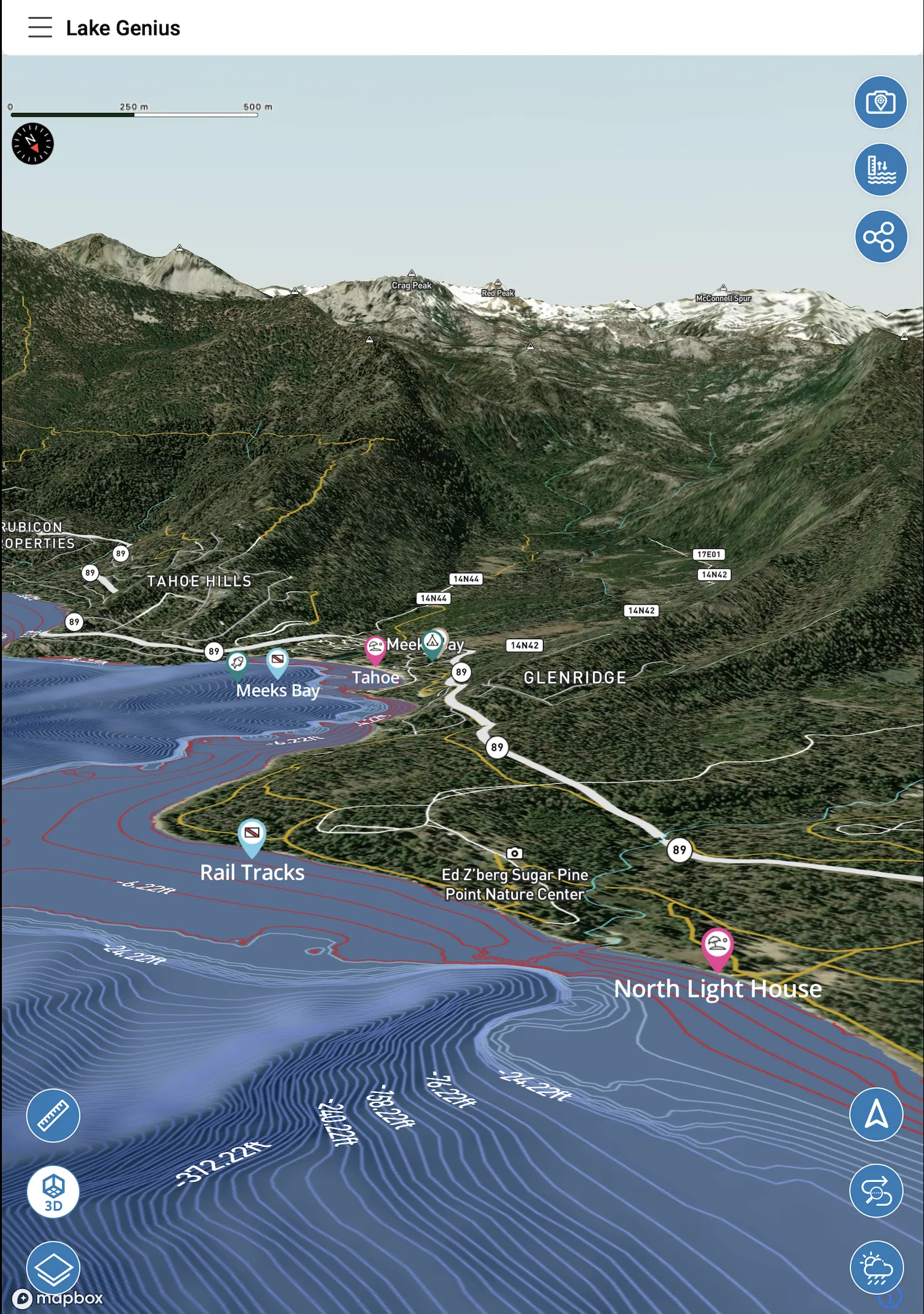
Lake Genius brings Lake Tahoe’s underwater terrain to the surface. Pull up the depth map, activate the X-Ray View, and explore both the California and Nevada shores with the kind of local knowledge that takes most boaters years to build up on their own.


More Than a Paper Map
Paper maps of Lake Tahoe show the outline. They tell you where the lake ends and the land begins. What they can’t tell you is what’s 6 feet under the surface near that beautiful cove in Emerald Bay, or how today’s water level has changed the depth at your favorite anchoring spot.
General navigation apps are built for roads. They know every highway between Reno and South Lake Tahoe, but the moment you’re on the water, you’re on your own.
Lake Genius is built for this lake. The depth map, the X-Ray View, the points of interest – it’s all specific to Lake Tahoe, updated daily, and designed for boaters who want to explore confidently.
See What's Under the Water – X-Ray View
Lake Tahoe’s water is famously clear. You can see 70 feet down in some areas. That clarity is stunning – and it can also be misleading. Rocky shoals near coves can look deeper than they are, and the way light hits the bottom shifts your perception of how close things are.
- 3D depth contours overlay directly on the map as you zoom in
- Anything within 9 feet of today's water surface is highlighted – the zone that matters for boat hulls, props, and swimmers
- The red shoreline shows the current water boundary based on today's water level reading
- Zoom in on any cove, bay, or anchoring spot and see the underwater terrain before you pull in
Whether you’re exploring Emerald Bay, anchoring near Sand Harbor, or running the east shore toward Cave Rock, the X-Ray View helps you read the water the way a local would.
Two States. 72 Miles of Shoreline. Every Cove Mapped.
Lake Tahoe spans the California-Nevada border, and the two sides of the lake offer distinctly different boating experiences. The California west shore is steep, dramatic, and home to the most iconic spots – Emerald Bay, D.L. Bliss State Park, and the deep waters off Rubicon Point. The Nevada east shore is sunnier, more accessible, and dotted with marinas and sandy beaches from Incline Village down to Zephyr Cove.
The West Shore (California)
Steep granite cliffs, deep water close to shore, and some of Tahoe’s most spectacular scenery. Emerald Bay is the crown jewel – but it requires careful navigation, and anchoring is regulated by California State Parks. The X-Ray View is particularly useful along this shore because the underwater terrain drops off steeply and conditions can be hard to judge by eye, even in Tahoe’s famously clear water.
The North Shore
Tahoe City and Kings Beach anchor the north end of the lake. This is where many day-boaters launch, and the marinas here provide fuel, rentals, and easy access to both the California and Nevada sides. The underwater terrain in the northern basin is shallower and more gradual than the west shore – useful to know when anchoring or towing.
The East Shore (Nevada)
Sand Harbor, Hidden Beach, and the stretch from Incline Village south to Zephyr Cove are some of Tahoe’s best for anchoring, swimming, and beach access by boat. The east shore gets more sun, calmer mornings, and generally gentler underwater terrain – though rocky shoals still sit near the surface in places.
The South Shore
South Lake Tahoe is the most developed area, with marinas, restaurants, and launch points. The underwater terrain transitions from the deep mid-lake basin (1,645 feet at maximum) to shallower, sandier bottom along the southern edge. Water sports are popular here, making hazard awareness especially important for tow boats.
The Lake Genius map covers the full 72-mile shoreline – both states, all four shores, every mapped cove and access point. The depth data, X-Ray View, and POI markers work seamlessly across state lines.
Fish Tahoe's Structure With the Depth Map
Lake Tahoe holds mackinaw (lake trout), rainbow trout, brown trout, and kokanee salmon – and fishing here is fundamentally about finding the right depth. The lake drops to 1,645 feet, but the productive zones are much shallower. Mackinaw move between 60 and 200 feet depending on the season. Rainbow and brown trout hold closer to shore, relating to rocky structure, points, and drop-offs in the upper water column. Kokanee suspend at mid-depths and can be maddeningly hard to locate without depth data.
The Lake Genius depth map shows the underwater terrain across the full lake. Zoom into any section and the X-Ray View renders contour lines, depth transitions, and the shape of the lake bottom – the kind of information that used to require expensive electronics and years on the water.
Find the structure
Rocky points along the east shore. The steep drop-offs near Rubicon Point on the west shore. The shallower flats along the south end where trout cruise in spring. The X-Ray View shows you where depth changes and structure exist – the spots where fish tend to hold.
Preview depth scenarios
Use the manual water level control to explore how different readings affect the depth picture at your target areas. Tahoe’s level moves less dramatically than some reservoirs, but even a few feet changes where the shallow structure intersects with the surface – and that affects where trout and mackinaw feed.
Mark your productive water
Drop custom markers on the spots that produce – the point where you caught mackinaw in fall, the rock pile where browns hold in spring, the kokanee zone that works at a specific depth. Build a personal fishing map that remembers what you’ve learned.
200+ Spots, Both Sides of the Lake
Lake Genius includes 200+ curated points of interest across Lake Tahoe – covering California and Nevada shores, from Tahoe City and Kings Beach in the north to South Lake Tahoe in the south.
Beaches & Anchoring Spots
From the wide sandy stretches of South Lake Tahoe to the sheltered coves of Emerald Bay, the app marks the beaches, swimming areas, and anchoring spots worth finding. Filter by what you’re looking for and navigate directly to it.
Marinas & Fuel
Lake Tahoe’s marinas are spread across both states. The app maps marina locations, launch ramps, and fuel docks across the full lake – including Tahoe City, Sunnyside, South Lake Tahoe, and Incline Village on the Nevada side. Tap any marker for details.
Diving & Underwater Points
Lake Tahoe is one of the top diving destinations in the western United States. The app marks established dive sites – including areas around Cave Rock, Rubicon Point, and other known locations – with depth context from the underwater terrain map.
Hiking Trailheads & Attractions
Boating and hiking often go together at Tahoe. The app marks trailhead access points reachable by water, viewpoints, and lakeside attractions on both the California and Nevada shores.
Mark Your Spots – Build Your Own Map of Tahoe
The best discoveries on Lake Tahoe are usually personal. The anchoring spot where you had the perfect morning. The cove that’s always calm when the rest of the lake is choppy. The depth where you consistently find fish.
Lake Genius lets you mark and save unlimited custom locations:
Drop a pin on any spot – name it, choose an icon, and it’s saved permanently on your map
Use the Photo Marker to take a picture of what you’re marking – a rock formation, a shoreline feature, a cove entrance – and the app pins it to the exact location
Share any marker with other Lake Genius users via text message – tap the link and the marker appears on their map automatically
Your spots stay saved as long as your subscription is active. Come back next summer and pick up exactly where you left off.
Download Lake Tahoe – Full App Works Offline
Cell coverage on Lake Tahoe is inconsistent. Emerald Bay, the west shore, and parts of the east shore can drop to little or no signal. If your map depends on a connection, you’re navigating blind in the spots that matter most.
Download the Lake Tahoe maps on Wi-Fi before you leave and everything works offline:
Full depth map with X-Ray View depth contours
All 200+ points of interest – both CA and NV sides
Your saved custom markers and photo markers
GPS tracking for your current position and planned routes
Water level updates and weather require a connection when those features are accessed – everything else works without one.
How Lake Genius Compares
Feature
Depth map for Lake Tahoe
X-Ray View (underwater terrain)
Daily water level updates
Points of interest (marinas, beaches, dive sites)
Works offline on the water
Save & share custom spots
Built specifically for Lake Tahoe
Paper Map
- No
- No
- No
- Limited
- (physical)
- No
- Generic
General Nav App
- No
- No
- No
- No
- Partial
- No
- No
Lake Genius
- Yes
- Yes
- Yes
- 200+
- Full download
- Yes
- Yes
TESTIMONIALS
What Lake Tahoe Boaters Are Saying
TESTIMONIAL PLACEHOLDER #1
A testimonial about the overall app experience — ideally from a boater who used multiple features on a single trip. Example: someone who planned from home, used the X-Ray View on the water, and found a hidden cove via POI. Should convey “this app changed how I experience the lake.”
— John
- Bear Lake
TESTIMONIAL PLACEHOLDER #1
A testimonial focused on hazard avoidance or money saved — someone who spotted a hazard before it became a problem. Connects to the X-Ray View and water levels features. Should convey “this paid for itself immediately.”
— Steve
- Bear Lake
TESTIMONIAL PLACEHOLDER #1
A testimonial about offline reliability or trip planning from home — especially relevant for families or houseboat renters. Should convey “I was confident even in areas with no cell service” or “we planned the whole trip before we left.”
— Gabrielle
- Lake Powell
Frequently Asked Questions
Is there a depth map for Lake Tahoe?
Is there a depth map for Lake Tahoe?
Yes – Lake Genius includes an interactive depth map for the full Lake Tahoe basin. The X-Ray View feature overlays 3D underwater terrain on the map as you zoom in, showing depth contours and anything near the surface in real time based on today’s water level. It covers both the California and Nevada sides of the lake.
How do I navigate Lake Tahoe by boat?
How do I navigate Lake Tahoe by boat?
Lake Genius gives you a GPS-enabled depth map of the full lake, with underwater terrain, X-Ray View, and 200+ points of interest including marinas, beaches, and fuel docks on both shores. Download the maps before your trip and the app works offline – useful on the west shore and in Emerald Bay where cell coverage drops.
What's in Emerald Bay – is it safe to anchor there?
What's in Emerald Bay – is it safe to anchor there?
Emerald Bay State Park is one of Tahoe’s most iconic spots, but it requires careful navigation. The bay has designated anchoring areas and is heavily visited in summer. Lake Genius shows the underwater terrain around the bay – use the X-Ray View to see depth and surface-near hazards before pulling in. Always follow California State Parks anchoring guidelines.
Does Lake Genius work on both the California and Nevada sides of Lake Tahoe?
Does Lake Genius work on both the California and Nevada sides of Lake Tahoe?
Yes – Lake Genius covers the full lake regardless of state boundaries. The depth map, X-Ray View, and all 200+ points of interest cover the complete shoreline – from Tahoe City and Kings Beach on the north shore to South Lake Tahoe, Emerald Bay, Sand Harbor, and Incline Village.
Can I use the Lake Genius map without cell service on Lake Tahoe?
Can I use the Lake Genius map without cell service on Lake Tahoe?
Yes. Download the Lake Tahoe maps before your trip on Wi-Fi and the full app works offline – depth map, X-Ray View, points of interest, GPS tracking, and your saved spots all work without a cell connection. Ideal for Emerald Bay and the west shore where coverage is often limited.
Explore Lake Tahoe Like a Local
Download Lake Genius free and get access to the full Lake Tahoe depth map, X-Ray View, 200+ points of interest, and offline navigation – all during your limited free trial. No credit card required.
See the lake in a whole new way.