App Features — Everything You Need
on the Water
Lake Genius is a boating app purpose-built for the needs of lake boaters. Daily underwater hazard updates, water level tracking, 2,000+ curated points of interest, trip planning from home, and offline maps that work where cell service doesn’t.
Every feature is included in one subscription. No add-ons, no tiered plans, no surprises.


Download Free — Try Every Feature With a Free Trial
Features
Top 4 Features
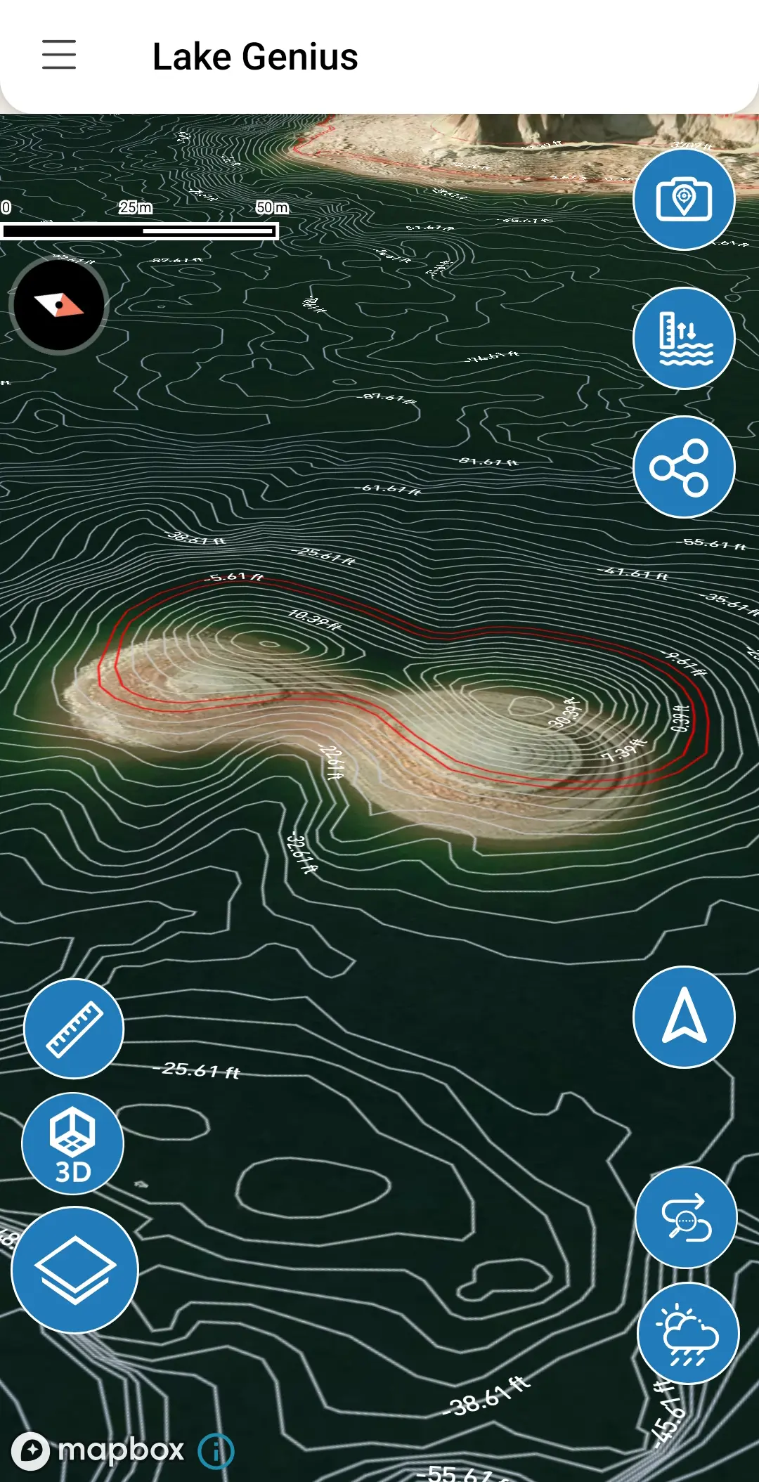
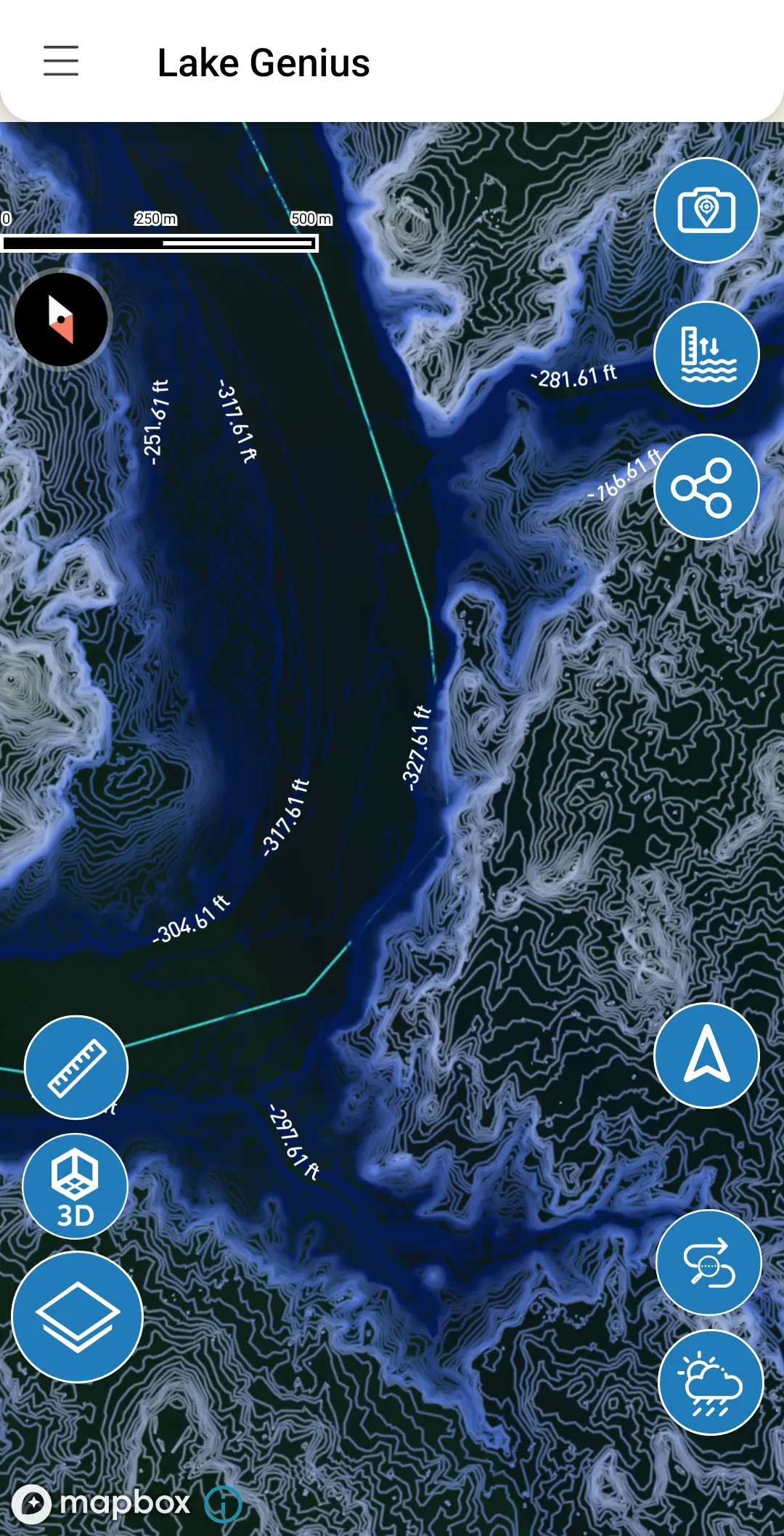
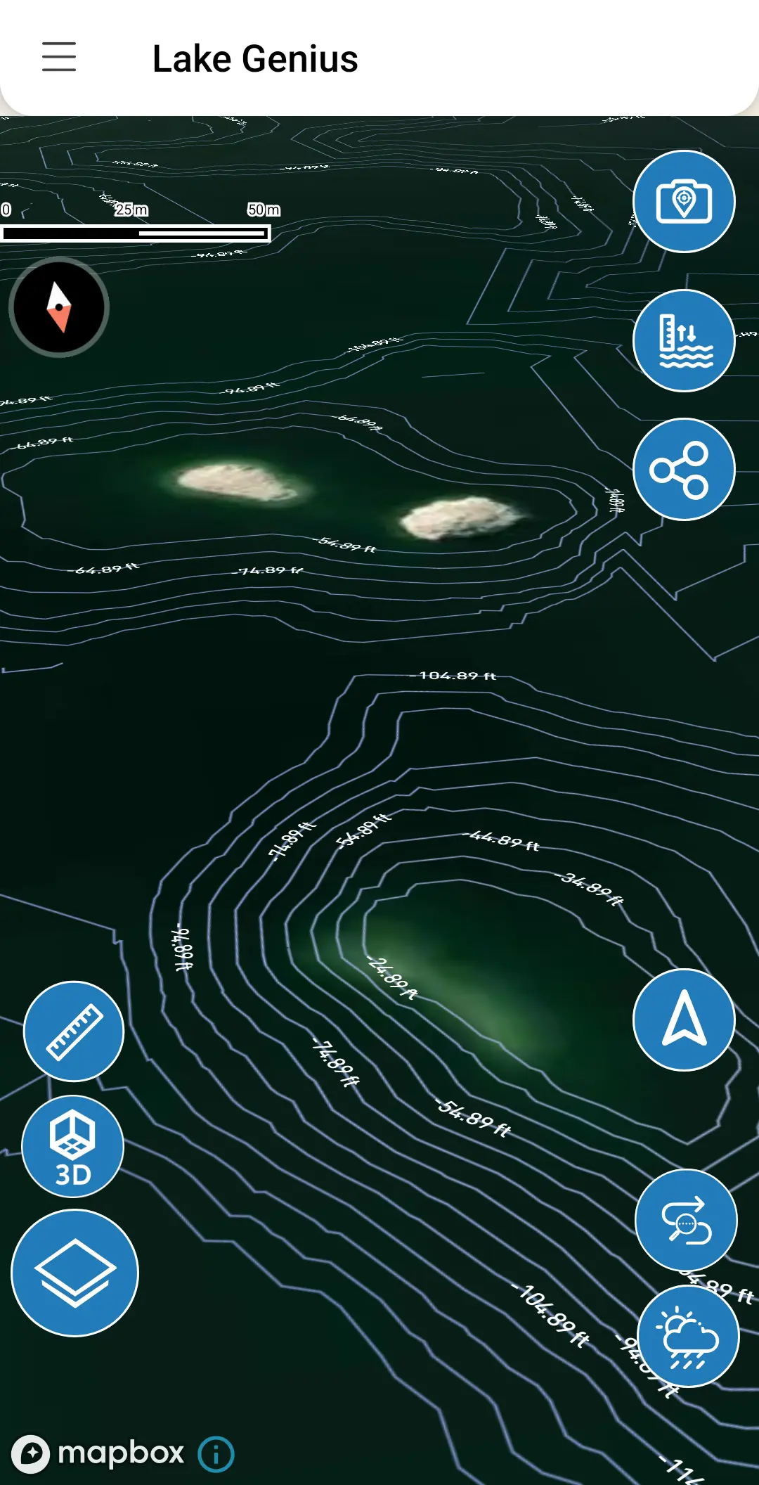
The X-Ray View — See What’s Under the Water
Lake Genius’s signature feature. Zoom into any area of the lake and a simulated X-Ray View reveals the underwater terrain beneath the surface — rocks, ledges, and hazards within 9 feet of the waterline. Updated daily, so you’re always seeing today’s conditions. No other boating app does this for the lakes we cover.
Daily Water Levels
Water levels change constantly, and what was safe last month might not be safe today. Lake Genius tracks water levels daily and displays the current shoreline in red on your map. Tap the water level button to see the exact reading in feet or meters.
Offline Maps — Works Where Cell Service Doesn’t
Most of the lakes we cover have limited or zero cell service once you’re on the water. Download your maps before you go and the app works fully offline — X-Ray View, POI markers, saved routes, and more. No signal needed.
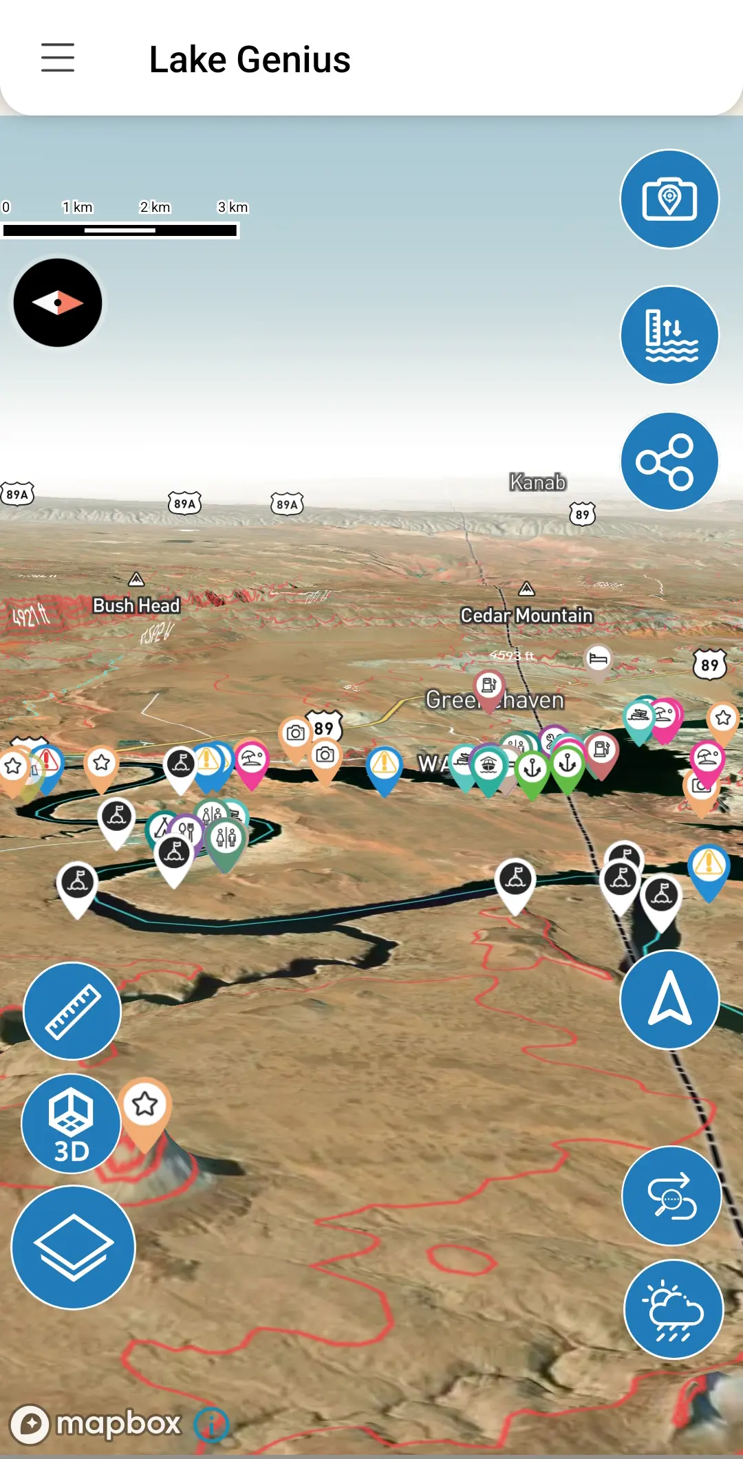
2,000+ Curated Points of Interest
Marinas, fuel docks, slot canyons, petroglyphs, hiking trailheads, swimming spots, fishing locations, and more — all curated by the Lake Genius team. Not crowdsourced, not user-generated. Our markers are vetted by people who know these lakes.
MORE FEATURES
More Built Into Every Subscription
Trip Planning & Route Tracking
Plan your route from home before your trip. Mark stops, estimate travel time and distance, track your GPS route on the water, and save unlimited routes for future visits.
Photo Marker
Snap a photo of a cove, rock formation, or fishing spot and the app pins it to your map. Enter a distance or tap the map to set the marker’s exact position in the direction your camera was pointing.
Mark & Save Favorite Spots
Drop unlimited custom markers on the map. Name them, choose an icon, and they’re saved permanently. Share your spots with friends and family via text message.
Weather Info
One-tap access to NOAA weather data for any point on the lake. Check conditions, wind, temperature, and precipitation before heading out or while you’re on the water.
Share Your Location
Send your GPS coordinates to friends, family, or marina staff with one tap via text message. Useful for meetups, raft-ups, and coordinating on the water.
How Lake Genius Compares
There are a few ways boaters typically try to navigate the lakes we cover. Here’s how they stack up.
Feature
Daily underwater hazard updates
Daily water levels
Lake-specific POI (curated)
Offline maps
Trip planning from home
Route saving & sharing
Built for these specific lakes
Lake Genius
- Yes
- Yes
- 2,000+
- Full offline
- Yes
- Unlimited
- Yes
Paper Maps
- No
- No
- Limited
- Physical
- No
- No
- Yes
Road Nav Apps
- No
- No
- No
- Limited
- No
- No
- No
Generic Boating Apps
- Static data
- Varies
- Crowdsourced
- Varies
- Basic
- Limited
- Worldwide / generic
Lake Genius isn’t trying to be everything for every boater everywhere. It’s built specifically for the lakes we know and love — with daily data updates, curated local knowledge, and features designed for how people actually use, enjoy, and navigate these lakes.
LAKES WE COVER
See It in Action on the Lakes We Cover
Every feature in Lake Genius is built around the specific conditions, hazards, and destinations of the lakes we cover. More lakes are being added! Here’s where you can use the app today.
Lake Powell
Ninety-six canyons, 2,000 miles of shoreline, and constantly shifting water levels. Lake Powell is where the X-Ray View matters most. Explore the full Lake Powell experience.
Lake Mead
Well-documented water level changes have reshaped the underwater landscape. Hazards that were deep underwater years ago now sit near the surface. See what Lake Genius offers at Lake Mead.
Bear Lake
Smaller and calmer, but the turquoise water and family-friendly beaches draw boaters all summer. Lake Genius covers underwater terrain, POI, and trip planning here too.
Lake Tahoe
Over 1,600 feet deep in places, with underwater terrain that changes fast near shore. Tahoe straddles the California-Nevada border and draws boaters year-round. Lake Genius maps both sides with the X-Ray View, comprehensive points of interest, and daily water level tracking.
Lake Roosevelt
The longest lake in Washington stretches 150 miles behind Grand Coulee Dam, with remote arms and canyons that see very little traffic and almost no cell coverage. Lake Genius provides comprehensive POI, offline maps, and daily hazard updates built for boaters well beyond the main channel.
Lake Pleasant
Phoenix boaters know the drill — summer heat means water levels that move fast, and what was deep last weekend might not be next. Lake Genius tracks Lake Pleasant daily with the X-Ray View, comprehensive POI, and offline-ready maps.
Lake Havasu
45 miles of Colorado River, from Lake Havasu City down to Parker Dam. Hundreds of hidden coves, the famous Bridgewater Channel, and some of the busiest summer boating in the West. Lake Genius maps the channels, marinas, and quiet anchorages, with daily underwater hazard updates and offline maps for when cell service drops in Topock Gorge.
Flaming Gorge
Carved through red rock canyons along the Utah-Wyoming border, Flaming Gorge is a 91-mile reservoir famous for trophy lake trout and dramatic, season-driven water level swings. Lake Genius tracks those changes daily and maps every marina, ramp, and cove, so you navigate the canyons and find the fishing without guessing what’s beneath you.
Mohave
67 miles of Colorado River between Hoover Dam and Davis Dam, with 237 miles of shoreline, canyon hot springs, and the quieter water boaters head to when Lake Mead gets crowded. Water levels move daily with dam operations, and Lake Genius tracks every change — so you know which ramps are open and what’s under the water before you launch.
More lakes are on the way. Download the app and you’ll get access to new lake coverage as it’s released — no additional cost.
One Subscription. Everything Included.
Every feature on this page is included in a single subscription. No feature tiers, no in-app purchases, no hidden costs.
Start with a free trial — full access to every feature, no credit card required. If it solves your problem, it’s $19.99/year.
Start Your Free Trial — Download on App Store · Google Play
Per Year
TESTIMONIALS
What Boaters Are Saying
We’ve taken several family houseboat trips to the lake in years past. We normally relied on maps.
I was happy to find an affordable electronic option when I learned of Lake Genius, so downloaded it and subscribed prior to our trip in mid-October 2025. Looking at the app at home I was impressed with the amount of detail concerning elevations and landmarks. In use on the lake, I had a hard time finding a zoom level that would show me both buoy locations and enough elevation / depth information to be useful while underway, but recent updates have fixed that. We found the app very useful overall and a great value.
— DonJ60
Rarely do I leave reviews on apps, but this is an absolute must have in Lake Powell!!
Thank you for an awesome app to help with boating —especially with Lake Powell newbies like us. Heck, even my long time Lake Powell buddies thought this was amazing.
— Mxracer317
- Lake Powell
This app is awesome!
Such a great way to spot underwater hazards easily on your phone. Saves you a lot of hassle and money from hitting your prop on a rock!
— Liv.ballam
Frequently Asked Questions
What features are included in Lake Genius?
What features are included in Lake Genius?
Every feature is included in one subscription: the X-Ray View for underwater hazard detection, daily water levels, 2,000+ curated points of interest, trip planning and route tracking, photo markers, custom spot saving, weather info, location sharing, and full offline maps. No add-ons or feature tiers.
Do all features work offline?
Do all features work offline?
Most features work fully offline once you’ve downloaded your maps. The X-Ray View, POI markers, saved routes, trip planning, photo markers, and saved spots all work without a signal. Weather info and water level updates require an internet connection when accessed.
Can I try Lake Genius before subscribing?
Can I try Lake Genius before subscribing?
Yes. Lake Genius offers a free trial with full access to every feature – no credit card required. Download the app, explore the map, check out the X-Ray View, and see if it works for you.
Is Lake Genius available on Android and iPhone?
Is Lake Genius available on Android and iPhone?
Yes. Lake Genius is available on both the Apple App Store (iOS) and Google Play Store (Android). Download on either platform and start your free trial.
What makes Lake Genius unique?
What makes Lake Genius unique?
Lake Genius is purpose-built for the specific lakes it covers. The app updates underwater hazard data daily — not monthly, not quarterly. Points of interest are curated by our team, not crowdsourced. And every feature works offline, which is critical for lakes with limited cell coverage.
See It in Action
Download Lake Genius and try every feature free. No credit card, no commitment. If you’re heading to one of the lakes we cover, you’ll want this on your phone.


Download Free on App Store · Google Play