The Lake Roosevelt Map Built for Boaters
One hundred and fifty miles. More than 600 miles of shoreline. Thirty-five National Recreation Area sites. Walleye in the Spokane Arm, rainbow trout near the net pens, kokanee in the deeper channels, and smallmouth bass along basalt cliff faces all the way to the Canadian border.
Lake Roosevelt is enormous. And unlike most lakes, the water level – and everything beneath the surface – moves based on Grand Coulee Dam operations you didn’t schedule.
Lake Genius gives you a map that keeps up. Interactive underwater terrain, daily water level updates, curated points of interest across the entire lake, and full offline functionality for the long stretches where cell service disappears. This is what it looks like to actually know where you are on Lake Roosevelt.
More Than a Paper Map
Paper charts of Lake Roosevelt do exist – impressive looking for a reservoir this large. But a printed chart can’t show you where the shoreline is today after the Bureau of Reclamation adjusted dam operations overnight. It can’t overlay underwater hazards at this morning’s actual water level. And it doesn’t update every day.
General navigation apps solve a different problem. They’re built for roads. No underwater data, no water level integration, no understanding of what a managed Columbia River reservoir means for where the bottom actually is.
Lake Genius is built for Lake Roosevelt specifically – with daily-updated depth contours, a live shoreline that reflects today’s water level, and points of interest across all 35 NPS recreation areas and beyond. It works offline. It fits in your pocket. And it updates while you’re still on Wi-Fi, so you’re covered before you ever leave the dock.
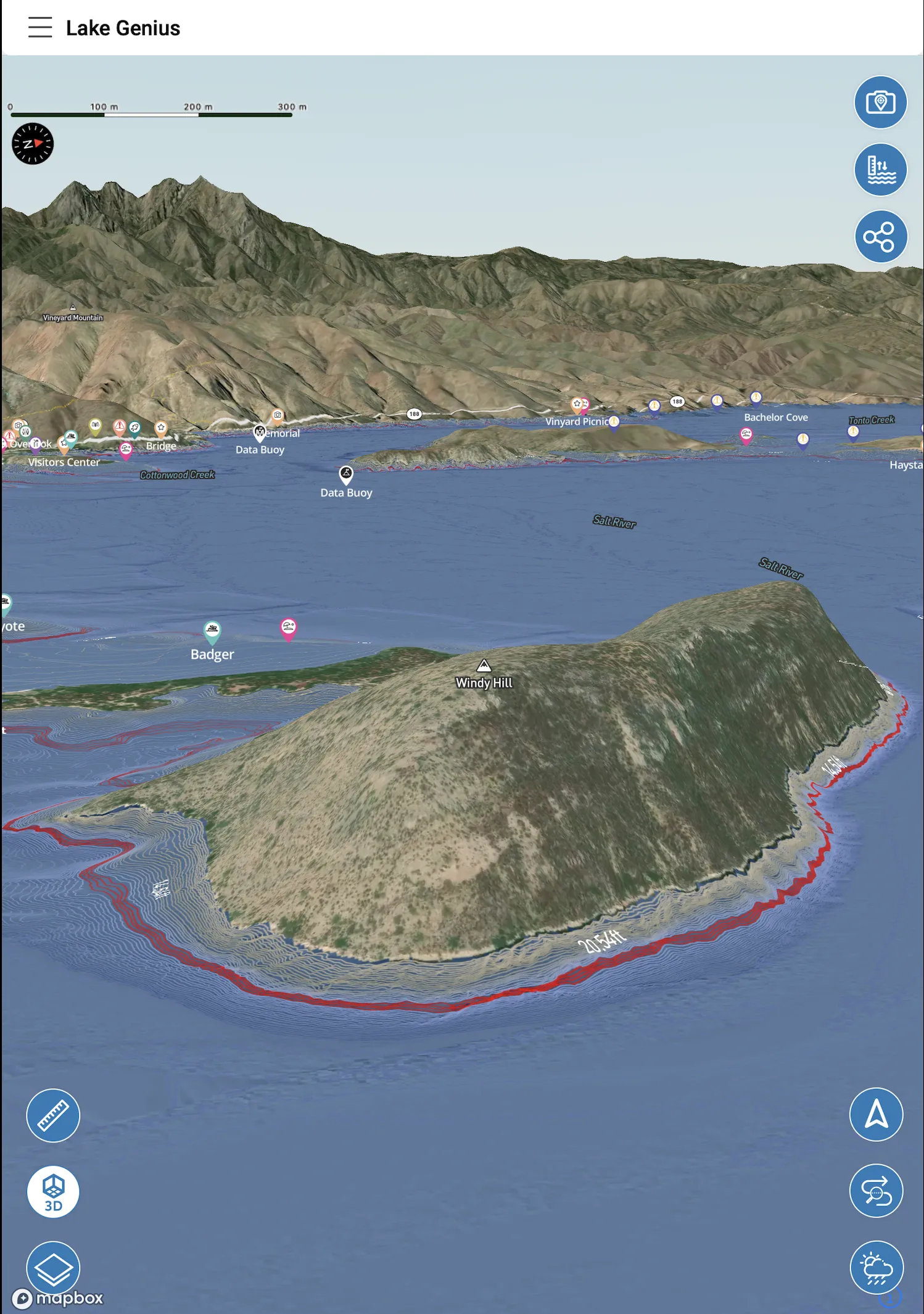
Underwater Terrain & Depth Contours
Lake Roosevelt is up to 375 feet deep in places – with underwater structure that varies dramatically across its length. Shallow rocky shelves near creek mouths and inlets, steep drop-offs along basalt canyon walls, submerged channels from the pre-dam Columbia River, and gradual flats in the Spokane Arm that hold walleye through spring and early summer.
All of that structure moves relative to the surface as the water level changes. A rocky shelf at 15 feet during full pool might be at 8 feet during the spring drawdown. The X-Ray View updates every day so the terrain you see on the map matches today’s conditions.
Zoom in on any part of the lake and the X-Ray View renders the terrain beneath the surface, highlighting hazards within nine feet of the current water line. For a reservoir managed the way Lake Roosevelt is, that daily update is the whole point.
35 Recreation Areas, Mapped
The National Park Service manages 35 recreation areas along Lake Roosevelt’s shoreline – ranging from full-service campgrounds with boat ramps and stores to remote sites accessible only by water. Knowing which are open, what each offers, and how to get there when you’re 80 miles up the lake requires more than a folded paper chart.
Lake Genius maps the full network of NPS recreation areas, boat ramps, marinas, campgrounds, beaches, and service locations across Lake Roosevelt. Key sites include:
Seven Bays Marina
boat rentals, fuel, store, and launch access near the Spokane Arm
Keller Ferry
campground, beach, and launch near the mid-lake crossing
Fort Spokane
NPS visitor center, campground, and swimming area at the Spokane River confluence
Kettle Falls
campground and launch in the upper lake, a popular walleye area
Spring Canyon
campground and launch near Grand Coulee Dam at the southern end
Each site is marked on your map with relevant details so you can plan stops, fuel runs, and overnight anchoring before you leave the dock.
Fish Smarter With the Depth Map
Lake Roosevelt is one of Washington’s premier walleye fisheries, and fishing here is fundamentally a structure game. Fish move between shallow rocky shelves in spring and early summer, then drop to 80–130 feet as water warms. The Spokane Arm holds significant numbers early in the season. The upper lake near Kettle Falls produces big fish through the fall.
The Lake Genius depth map shows underwater contours – drop-offs, shelves, submerged channels – across all 150 miles. Use the manual water level adjustment to scout structure and depth at different scenarios before you leave the dock.
The same approach works for rainbow trout, kokanee, and smallmouth bass – each species holding at different depths and relating to different types of structure depending on the time of year. Spend more time fishing, less time searching.
Camping, Beaches & Remote Recreation
Some of the best spots on Lake Roosevelt can only be reached by boat. Porcupine Bay, tucked into the Spokane Arm among ponderosa pines. Hawk Creek, with its small waterfall and the feeling of total seclusion. Dozens of beaches and coves along the upper lake that most visitors never find because they have no map that shows them.
Lake Genius maps campgrounds, beaches, swimming areas, boat-in sites, and hiking trailheads across the full length of the lake. Find a place to anchor overnight, identify a beach for a midday stop, or plan a multi-day loop through NPS campgrounds – all from the map, before you leave the dock.
The Photo Marker feature lets you take a picture of any spot and pin it to the map instantly. Found the perfect beach? Mark it. Discovered a sheltered cove? Pin it. Come back next summer and find it again without guessing.
Build Your Own Map
The Lake Genius map becomes your map over time. Drop unlimited custom markers – name them, assign an icon, and they stay on your map permanently. Your walleye shelf near Porcupine Bay. Your go-to beach in the Spokane Arm. The cove your kids found last summer. Every spot you’ve discovered over years on Lake Roosevelt, saved in one place.
Share any marker with another Lake Genius user via text message. They tap the link, the app opens, and the marker drops onto their map automatically. No screenshots, no coordinates, no explaining where you mean.
The Photo Marker adds a visual layer: take a photo of anything on the water and the app pins it to the map at your current location. Perfect for marking a rock formation, a beach approach, or any spot you want to identify visually on the next trip.
Download for Offline Use
From Grand Coulee Dam north toward Canada, cell service on Lake Roosevelt is inconsistent at best and nonexistent across most of the remote stretches. That’s not a problem if you’ve downloaded your maps before you launch.
Download Lake Roosevelt’s maps over Wi-Fi before your trip and the app works fully offline – depth contours, POI markers, your custom markers, X-Ray View, and GPS route tracking. Everything you need, no signal required.
Weather notices and water level updates do need a connection when accessed. Check those before you leave the dock and you’re covered for the day.
How Lake Genius Compares
Capability
Daily water level updates
Underwater terrain / depth
Hazard detection (9 ft range)
NPS recreation area markers
Custom markers & photo pins
Offline functionality
Lake Roosevelt–specific data
Paper Chart
- Static
- Static only
- No
- Not digital
- No
- Always
- Generic
Generic Nav App
- No lake data
- No underwater data
- No
- Limited
- No
- Partial
- Generic
Lake Genius
- Updated daily
- Daily-updated contours
- X-Ray View
- All 35 sites mapped
- Unlimited
- Full offline capability
- Built for this lake
TESTIMONIALS
What Boaters Are Saying
TESTIMONIAL PLACEHOLDER #1
A testimonial about the overall app experience — ideally from a boater who used multiple features on a single trip. Example: someone who planned from home, used the X-Ray View on the water, and found a hidden cove via POI. Should convey “this app changed how I experience the lake.”
— John
- Bear Lake
TESTIMONIAL PLACEHOLDER #1
A testimonial focused on hazard avoidance or money saved — someone who spotted a hazard before it became a problem. Connects to the X-Ray View and water levels features. Should convey “this paid for itself immediately.”
— Steve
- Bear Lake
TESTIMONIAL PLACEHOLDER #1
A testimonial about offline reliability or trip planning from home — especially relevant for families or houseboat renters. Should convey “I was confident even in areas with no cell service” or “we planned the whole trip before we left.”
— Gabrielle
- Lake Powell
Frequently Asked Questions
Is there a map app for Lake Roosevelt?
Is there a map app for Lake Roosevelt?
Yes – Lake Genius is built specifically for boating on Lake Roosevelt and other lakes. The app includes an interactive map with underwater terrain, daily-updated depth contours, X-Ray View hazard detection, curated points of interest across all 35 NPS recreation areas, and full offline functionality for remote stretches of the lake.
How deep is Lake Roosevelt?
How deep is Lake Roosevelt?
Lake Roosevelt reaches depths of up to 375 feet in sections near Grand Coulee Dam. Depth varies significantly across the lake’s 150-mile length – from the relatively shallow Spokane Arm to the deep, narrow canyon sections further north. Lake Genius displays depth contours across the full lake, updated daily based on the current water level.
Does Lake Genius include a fishing map for Lake Roosevelt?
Does Lake Genius include a fishing map for Lake Roosevelt?
Yes. The Lake Genius map shows underwater terrain, depth contours, and the locations of drop-offs, shelves, and submerged structure – all key to finding walleye, rainbow trout, kokanee, and smallmouth bass on Lake Roosevelt. You can also manually adjust the displayed water level to scout depth at different scenarios and save your own fishing spots with custom markers.
Does the Lake Roosevelt map work without cell service?
Does the Lake Roosevelt map work without cell service?
Yes. Download the map before your trip and the full app works offline – depth contours, POI markers, custom markers, X-Ray View, and GPS tracking. Weather notices and water level updates require a connection when accessed, so check before you leave Wi-Fi range.
How do I find boat ramps and campgrounds on Lake Roosevelt?
How do I find boat ramps and campgrounds on Lake Roosevelt?
Lake Genius maps all major boat launches, NPS campgrounds, marinas, beaches, and recreation areas across Lake Roosevelt. Browse the map to find sites by location, or use the points of interest filter to show specific categories – marinas, campgrounds, boat ramps, and more.
150 Miles of Lake. One Map That Keeps Up.
From Grand Coulee Dam to the Canadian border, Lake Roosevelt rewards the boater who knows where to look. The depth map, the daily water level overlay, the NPS recreation sites, the fishing structure – it’s all in Lake Genius, updated every day, and ready to use offline the moment you’re out of range.


Try it for free – just download the app to start your free trial. No credit card required.